A51 autoroute
 | |
|---|---|
| Autoroute du Trièves (Northern section) | |
 | |
| Route information | |
| Part of | |
| Maintained by Bouches-du-Rhône, AREA, ESCOTA | |
| Length | 172 km (107 mi) |
| Existed | 1953–present |
| Major junctions | |
| South end | |
| |
| North end | |
| Location | |
| Country | France |
| Highway system | |
| |

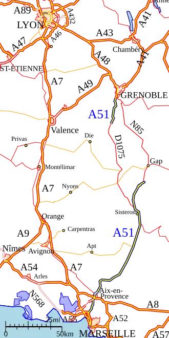
The A51 autoroute is a partly completed motorway in southeast France. It currently exists as two sections separated by a gap of approximately 85 km, the northern section sometimes referred to as the A51N.[1]
It is the long-term project to connect Marseille to Grenoble via Aix-en-Provence, the Durance Valley and the Hautes-Alpes department, providing a high-capacity alternative to the heavily used A7 following the Rhône valley.
History
The first section was built in 1953, it connected the Autoroute de nord (open in 1951) to Cabriès. It was only extended to Aix-en-Provence and the A8 in 1970. The construction of the section from Grenoble to Sisteron was subject to protests because of its environmental impact. In 1995 for example, demonstrators blocked work by chaining themselves to construction equipment.
Northern section
The section at the Grenoble end, from Varces to Coynelle (17 km), was opened in July 1999. This was extended in March 2007 when the next section, connecting Coynelle to the Col du Fau (10.5 km), was opened in March 2007.
This section includes 4.5 km of single carriageway through the Tunnel of Sinard and over the Viaduct de Monestier. The opening of this section has greatly reduced the summer congestion through the commune of Monestier. This northern section is a toll road operated by AREA.
Southern section
The motorway passes the cities of Aix-en-Provence, Pertuis, Manosque, Sisteron and then Digne-les-Bains and Tallard. In the Isère department, it passes Monestier-de-Clermont, Vif and Varces-Allières-et-Risset. The motorway provides access to the southwestern Alps for the residents of the South of France.
Its southern section connects Marseille to Aix-en-Provence and the Durance Valley to the north of Sisteron (Saulce). Only 18 km is toll free between Marseilles and Aix-en-Provence, the remaining 128 km is a toll road operated by Escota between Aix-en-Provence and Saulce. At Aix-en-Provence, the autoroute becomes briefly the N296 dual-carriageway between the exits Jas-de-Boufan and Aix-les-Platanes. This section where it meets the N7 was originally proposed to be an autoroute but building has subsequently compromised the route. There is a speed limit of 50 km/h on part of the N296.
List of junctions
Southern section
| Region | Department | Junction | Destinations | Notes | ||
|---|---|---|---|---|---|---|
| Provence-Alpes-Côte d'Azur | Bouches-du-Rhône | Marseille - centre, Saint-Antoine | ||||
| Fos - Martigues (A55), |
||||||
| Aix-en-Provence - Jas-de-Bouffan, Encagnane, Les Milles | ||||||
( |
Gardanne, Simiane-Collongue, Bouc-Bel-Air | Entry and exit from Marseille | ||||
| Aix-en-Provence - Pôle d'Activités, Bouc-Bel-Air, Luynes | ||||||
| Gardanne, Luynes | ||||||
| Aix-en-Provence - Pôle d'Activités, Pont-de-l'Arc, Les Milles, | ||||||
| Aix-en-Provence | ||||||
| Lyon (A7), Avignon, Salon-de-Provence | ||||||
| Nice, Toulon (A52), Aubagne, Aix-en-Provence - Pont de l'Arc, Val-Saint-André | ||||||
| Berre-l'Étang, Aix-en-Provence - Encagnane, centre, Lyon (A8), Avignon, Salon-de-Provence | ||||||
| Aix-en-Provence - Pontier, Centre Hospitalier du Pays d'Aix | Entry and exit from Gap | |||||
| Gap (A51), La Chevalière | ||||||
| Nîmes, Avignon, Salon-de-Provence, Saint-Cannat, Célony | ||||||
| Le Puy-Sainte-Réparade, Aix-en-Provence, Oppidum d'Entremont | ||||||
| Chemin Saint-Donat | ||||||
| Aix-en-Provence - nord | ||||||
| Venelles | ||||||
| Gap, Digne-les-Bains, Sisteron, Manosque, Meyrargues, Pertuis | Entry and exit from Marseille | |||||
| Le Puy-Sainte-Réparade, Pertuis | ||||||
| Saint-Paul-lès-Durance, Vinon-sur-Verdon, Gréoux-les-Bains, Centre d'Études Atomiques de Cadarache | ||||||
| Alpes-de-Haute-Provence | Valensole, Gréoux-les-Bains, Manosque | |||||
| Forcalquier, Oraison | ||||||
| Digne-les-Bains, Château-Arnoux-Saint-Auban, Les Mées, Peyruis | ||||||
| Nice, Digne-les-Bains, Château-Arnoux-Saint-Auban, Aubignosc | ||||||
| Sisteron - centre, Vallée du Jabron | ||||||
| Grenoble by the Col de la Croix-Haute, Sisteron, La Motte-du-Caire, Laragne-Montéglin | ||||||
| Hautes-Alpes | Gap, La Saulce, Tallard, Curbans, La Motte-du-Caire | |||||
| 1.000 mi = 1.609 km; 1.000 km = 0.621 mi | ||||||
Northern section
| Region | Department | Junction | Destinations | Notes | ||
|---|---|---|---|---|---|---|
| Auvergne-Rhône-Alpes | Isère | |||||
| Varces, Claix - Les Bauches | Entry and exit from Grenoble | |||||
| Saint-Paul de Varces | Entry and exit from Grenoble | |||||
| Sisteron par RD, Vif, Varces | ||||||
| Sinard, Lac de Monteynard-Avignonet | Entry and exit from Grenoble | |||||
| 1.000 mi = 1.609 km; 1.000 km = 0.621 mi | ||||||
Future
Following many ministerial and policy changes, and tensions between local residents. As a result, the completion of the motorway has been on the agenda for 20 years.
Were all the sections are completed the road journey from Grenoble-Marseille would be 2h40 (instead of the current 3h30). However, there are several problems:
- The design of the road
- The class of roads (toll/free autoroute, expressway or upgrade of the current roads (N75 and N85)
- The cost of the project.
- Strong environmental impact of the route.
The motorway must pass through the middle of the South-Dauphiné (Trièves) Alps. There were two options for the route between the Col de Fau (Monestier-de-Clermont) and the end of the southern section near Gap:
- The "High Route" was the most direct route over several high passes to Sisteron (The budget at the time was envisaged at 1.8 billion euros)
- "Gap East" (via the Drac valley, the Col de Bayard and the Avance valley) to Saulce the current end of the motorway from Marseille (the budget was envisaged to be approximately 2.2 billion euros).
Following a public inquiry organized between 2005 and 2006, the Minister Mr Perben announced in 2006 that A51 would be built on the Gap East route. However the 2011 edition of the National Scheme of Transport Infrastructure (SNIT) did not include the completion of this section. Completion before 2025 is unlikely.
References
- ^ "Online map service of the French national mapping agency". géoportail. Retrieved 21 April 2025.
External links