A48 autoroute
 | |
|---|---|
| Autoroute du Dauphiné | |
 | |
| Route information | |
| Part of | |
| Maintained by AREA | |
| Length | 52.5 km (32.6 mi) |
| Existed | 1968–present |
| Major junctions | |
| South end | |
| North end | |
| Location | |
| Country | France |
| Highway system | |
| |
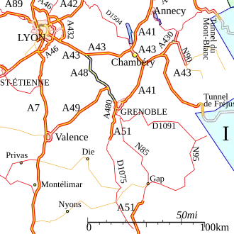
The A48 autoroute, also known as l'autoroute du Dauphiné, is a motorway in France connecting the A43 with the city of Grenoble.
An extension north to Ambérieu is proposed in the medium term.
Characteristics
- 2x2 lanes
- 2x3 lanes between the A49 and A480 autoroutes (10 km)
- 97 km long
- Service areas
History
- 1968: The first toll free section opened between the Bastille (Grenoble northern edge) and Voreppe as part of the preparations for the Winter Olympics held in the city and surrounding area.
- 1975: Opening of the toll section between Voreppe and the A43 managed by AREA.
Junctions
| Region | Department | Junction | Destinations | Notes | ||
|---|---|---|---|---|---|---|
| Auvergne-Rhône-Alpes | Isère | Strasbourg (A39), Paris (A6), Bourg-en-Bresse (A42), Lyon, Lyon-Saint-Exupéry Airport, Bourgoin-Jallieu | ||||
| Genève (A41), Chambéry, La Tour-du-Pin | ||||||
| Vienne, Rives, La Côte-Saint-André, Lac de Paladru, Grenoble-Isère Airport | ||||||
| Voiron - Champfeuillet, Les Abrets | ||||||
| Coublevie, Moirans, Voreppe, Voiron - centre, Centre'Alp | ||||||
| Marseille (A7), Valence | ||||||
| Valence par RD, Voreppe | ||||||
| Lyon, Voiron par RD, Voreppe | ||||||
| Saint-Égrève - nord, Fontanil-Cornillon, Autrans, Villard-de-Lans | ||||||
| Grenoble - centre, Rocade Sud, Sisteron (A51), Turin - Milan | ||||||
| Saint-Martin-le-Vinoux, Grenoble - Bastille, Presqu'Île, Hôpital Nord | ||||||
| Z. I. Saint-Martin-le-Vinoux, Z. I. Saint-Égrève | Entry and exit from Grenoble | |||||
| Grenoble - Presqu'Île, Parc d'Oxford, Europôle | ||||||
| Saint-Martin-le-Vinoux, Saint-Égrève - sud | Entry and exit from Grenoble | |||||
| End of the | ||||||
| 1.000 mi = 1.609 km; 1.000 km = 0.621 mi | ||||||
Places of interest
The following list indexes towns and places of interest that can be visited from the motorway:
- River Isère
- Col de Rossatière
- Lac de Paladru
- Chartreuse Mountains
Future
There are proposals to extend the autoroute north from Bourgoin-Jallieu to Ambérieu-in-Bugey and connecting to the A42 autoroute.
External links
Template:Attached KML/A48 autoroute
KML is from Wikidata
- A48 autoroute in Saratlas