A46 autoroute
 | |
|---|---|
 | |
| Route information | |
| Part of | |
| Maintained by DIR Centre-Est, APRR and ASF | |
| Length | 59 km (37 mi) |
| Existed | 1992–present |
| Major junctions | |
| North end | |
| South end | |
| Location | |
| Country | France |
| Highway system | |
| |
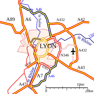
The A46 autoroute is a 61.2-kilometre-long (38.0 mi) highway in central France. It connects the town of Givors to Anse and eastern Lyon. It was completed in 1992.
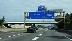
Characteristics
- 2x2 lanes (2X3 lanes at Rillieux-la-Pape)
- 65 km long
- A radar speed trap has been installed at Rillieux-la-Pape (southbound). Speed limit 90 km/h.
History
- 1992 : Opening of the A46 and the RN346.
- 2007 : Opening of the third lane between Genay and the Mionnay Service Area.
Since 2002, there have been further attempts to prohibit heavy traffic over 7.5 tons in Lyon and divert them onto this motorway-by-pass. This is controversial because it generates extra journey times distances travelled.
Junctions
| Region | Department | Junction | Destinations | Notes | ||
|---|---|---|---|---|---|---|
| Auvergne-Rhône-Alpes | Rhône | Paris, Villefranche-sur-Saône, Mâcon | ||||
| Quincieux, Trévoux, Ambérieux d'Azergues | ||||||
| Lyon - ouest (M6), Clermont-Ferrand, Bordeaux (A89) | Entry and exit from A7 | |||||
| Genay, Trévoux, Neuville-sur-Saône, Z. I. Lyon - Nord | ||||||
| Ain | ||||||
| Mionnay, Bourg-en-Bresse, Montanay, Villars-les-Dombes | Entry and exit from A7 | |||||
| Aéroport de Lyon-Saint-Exupéry, Grenoble (A43), Genève (A42) | Entry and exit from A6 | |||||
| Les Échets, Bourg-en-Bresse, Villars-les-Dombes, Villefranche-sur-Saône | ||||||
| Rhône | Caluire-et-Cuire, Rillieux-la-Pape | |||||
| Strasbourg (A39), Genève (A40), Bourg-en-Bresse, Aéroport de Lyon-Saint-Exupéry | ||||||
| Lyon - nord, Villeurbanne | ||||||
| Vaulx-en-Velin, Décines-Charpieu - Les Marais, Parc de Miribel-Jonage | ||||||
| Meyzieu, Décines-Charpieu - centre, Le Grand Large | ||||||
| Parc Olympique Lyonnais | ||||||
| Pont-de-Chéruy, Pusignan, Z. I. Meyzieu | ||||||
| Genas, Chassieu - centre, Les Sept Chemins, Eurexpo - Visiteurs | ||||||
| Z. I. Mi-Plaine, Chassieu, Genas, Eurexpo - Exposants | ||||||
| Grenoble, Chambéry par RD, Saint-Bonnet-de-Mure, Z. I. Mi-Plaine, Saint-Priest | ||||||
| Grenoble, Chambéry, Turin, Aéroport de Lyon-Saint-Exupéry, Lyon - est | ||||||
| Saint-Priest | ||||||
| Saint-Priest, Heyrieux, Mions - Les Meurières | ||||||
| Mions - centre, Z. I. Lyon - Sud-Est / Pierres Blanches | ||||||
| Vénissieux, Corbas, Z. I. Lyon - Sud-Est / Montmartin (Boulevard urbain sud de Lyon), Lyon - sud | ||||||
| Saint-Symphorien-d'Ozon, Corbas, Marennes, Chaponnay | ||||||
| Ternay, Communay | ||||||
| Z. A. des Platières, Z. A. de Charvas | Exit only from A7 | |||||
| Marseille, Valence, Vienne | ||||||
| Saint-Étienne, Givors, Chasse-sur-Rhône, Clermont-Ferrand (A72) | ||||||
| 1.000 mi = 1.609 km; 1.000 km = 0.621 mi | ||||||
External links
Template:Attached KML/A46 autoroute
KML is from Wikidata
- A46 autoroute in Saratlas