A23 autoroute
 | |
|---|---|
 | |
| Route information | |
| Maintained by DIR Nord | |
| Length | 43 km (27 mi) |
| Existed | 1978–present |
| Major junctions | |
| North end | |
| South end | |
| Location | |
| Country | France |
| Highway system | |
| |
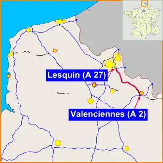
The A23 autoroute is a highway in northern France. It is 42.5 kilometres (26.4 mi) long. The highway passes northwest–southeast from the Lille conurbation to the town of Valenciennes effectively linking the A1 and A2 autoroutes.
Junctions
| Region | Department | Junction | Destinations | Notes | ||
|---|---|---|---|---|---|---|
| Hauts-de-France | Nord | Paris, Lille, Calais, (A25) | ||||
| Gand, Tourcoing (A22), Roubaix, Villeneuve-d'Ascq | ||||||
| Lesquin, Aéroport de Lille | ||||||
| Orchies, Somain, Lens, Seclin, Douai, Tournai (Belgium) | ||||||
| St-Amand-les-Eaux, Marchiennes | ||||||
| Saint-Amand-Les-Eaux, Wallers | ||||||
| Saint-Amand-Les-Eaux, Tournai (Belgium) | ||||||
| Raismes | ||||||
| Petite-Forêt, Raismes, Beuvrages, Wallers | ||||||
| Valenciennes- Saint-Waast, Anzin | ||||||
| Valenciennes - Le Vignoble, La Sentinelle, Trith-Saint-Léger | ||||||
| Valenciennes - centre, Paris (A1), Cambrai, Denain, Liège, Maubeuge, Bruxelles | ||||||
| 1.000 mi = 1.609 km; 1.000 km = 0.621 mi | ||||||
References
External links
Template:Attached KML/A23 autoroute
KML is from Wikidata