Portal:Washington (state)
The Washington Portal Panoramic view from Washington Pass Observation Site (a.k.a. Washington Pass Overlook), Okanogan County, Washington (2023)
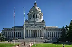
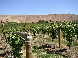
 Washington, officially the State of Washington, is a state in the Pacific Northwest region of the United States. It is often referred to as Washington state to distinguish it from the national capital, both named after George Washington (the first U.S. president). Washington borders the Pacific Ocean to the west, Oregon to the south, Idaho to the east, and shares an international border with the Canadian province of British Columbia to the north. Olympia is the state capital, and the most populous city is Seattle. Washington is the 18th-largest state, with an area of 71,362 square miles (184,830 km2), and the 13th-most populous state, with a population of just less than 8 million. The majority of Washington's residents live in the Seattle metropolitan area, the center of transportation, business, and industry on Puget Sound, an inlet of the Pacific Ocean consisting of numerous islands, deep fjords and bays carved out by glaciers. The remainder of the state consists of deep temperate rainforests in the west; mountain ranges in the west, center, northeast, and far southeast, and a semi-arid basin region in the east, center, and south, given over to intensive agriculture. Washington is the second most populous state on the West Coast and in the Western United States, after California. Mount Rainier, an active stratovolcano, is the state's highest elevation at 14,411 feet (4,392 meters), and is the most topographically prominent mountain in the contiguous U.S. Washington is a leading lumber producer, the largest producer of apples, hops, pears, blueberries, spearmint oil, and sweet cherries in the U.S., and ranks high in the production of apricots, asparagus, dry edible peas, grapes, lentils, peppermint oil, and potatoes. Livestock, livestock products, and commercial fishing—particularly of salmon, halibut, and bottomfish—are also significant contributors to the state's economy. Washington ranks third in wine production. Manufacturing industries in Washington include aircraft, missiles, shipbuilding, and other transportation equipment, food processing, metals, and metal products, chemicals, and machinery. (Full article...)
| ||||||||||||||||||||||||||||||||||||||||||||||||||||

.jpg)


_(ADVERT_26).jpeg)


.jpg)


.png)
.jpg)

_during_the_attack_on_Chantilly%252C_Viriginia_1862.jpg)
_(3463993465).jpg)


.jpg)


| Federal |
| ||||||||||||||||||||||||||||
|---|---|---|---|---|---|---|---|---|---|---|---|---|---|---|---|---|---|---|---|---|---|---|---|---|---|---|---|---|---|
| State |
| ||||||||||||||||||||||||||||
| Other |
| ||||||||||||||||||||||||||||
Categories

New articles
This list was generated from these rules. Questions and feedback are always welcome! The search is being run daily with the most recent ~14 days of results. Note: Some articles may not be relevant to this project.
Rules | Match log | Results page (for watching) | Last updated: 2025-08-18 21:09 (UTC)
Note: The list display can now be customized by each user. See List display personalization for details.
- Soroosh Abdi (edit | talk | history | links | watch | logs | tools) by FencerFightWarrior (talk · contribs · new pages (1)) started on 2025-08-18, score: 62
- Carole Green (edit | talk | history | links | watch | logs | tools) by PA Uploader (talk · contribs · new pages (44)) started on 2025-08-18, score: 34
- Jordan Thompson (soccer) (edit | talk | history | links | watch | logs | tools) by Schestos (talk · contribs · new pages (15)) started on 2025-08-18, score: 34
- Suquamish Indian Tribe (edit | talk | history | links | watch | logs | tools) by PersusjCP (talk · contribs · new pages (3)) started on 2025-08-17, score: 35
- Suquamish people (edit | talk | history | links | watch | logs | tools) by PersusjCP (talk · contribs · new pages (3)) started on 2025-08-17, score: 52
- Emma Gaines-Ramos (edit | talk | history | links | watch | logs | tools) by Hameltion (talk · contribs · new pages (11)) started on 2025-08-17, score: 34
- Thomas C. Rabbitt (edit | talk | history | links | watch | logs | tools) by PequodOnStationAtLZ (talk · contribs · new pages (4)) started on 2025-08-17, score: 68
- Prentice (surname) (edit | talk | history | links | watch | logs | tools) by Charles Matthews (talk · contribs · new pages (24)) started on 2025-08-17, score: 20
- Peter Reed (politician) (edit | talk | history | links | watch | logs | tools) by Moondragon21 (talk · contribs · new pages (205)) started on 2025-08-17, score: 20
- Arthur J. Gronna (edit | talk | history | links | watch | logs | tools) by Patken4 (talk · contribs · new pages (3)) started on 2025-08-16, score: 24
- Da'Marcus Johnson (edit | talk | history | links | watch | logs | tools) by KerbHopper (talk · contribs · new pages (36)) started on 2025-08-16, score: 30
- Edward Read (politician) (edit | talk | history | links | watch | logs | tools) by Moondragon21 (talk · contribs · new pages (205)) started on 2025-08-15, score: 20
- 2025 Pac-12 Conference football season (edit | talk | history | links | watch | logs | tools) by Vataxevader (talk · contribs · new pages (3)) started on 2025-08-15, score: 22
- Alexander W. Hunter (edit | talk | history | links | watch | logs | tools) by Craft777 (talk · contribs · new pages (2)) started on 2025-08-07, score: 26
- Bigfoot 200 (edit | talk | history | links | watch | logs | tools) by Dr. Blofeld (talk · contribs · new pages (3)) started on 2025-08-15, score: 74
- Congrats (horse) (edit | talk | history | links | watch | logs | tools) by Jnglmpera (talk · contribs · new pages (4)) started on 2025-08-15, score: 21
- Sitting Bull (disambiguation) (edit | talk | history | links | watch | logs | tools) by Laterthanyouthink (talk · contribs · new pages (57)) started on 2025-08-15, score: 28
- Patti Lewis (edit | talk | history | links | watch | logs | tools) by Moondragon21 (talk · contribs · new pages (205)) started on 2025-08-15, score: 20
- Port of Olympia (edit | talk | history | links | watch | logs | tools) by OlympiaBuebird (talk · contribs · new pages (8)) started on 2025-08-14, score: 55
- Cavitnak (edit | talk | history | links | watch | logs | tools) by Polandball100 (talk · contribs · new pages (2)) started on 2025-08-14, score: 28
- Robert S. Shields (edit | talk | history | links | watch | logs | tools) by JJLiu112 (talk · contribs · new pages (5)) started on 2025-08-14, score: 34
- Kaia Tupu-South (edit | talk | history | links | watch | logs | tools) by Hildreth gazzard (talk · contribs · new pages (142)) started on 2025-08-14, score: 34
- List of people executed in Washington (pre–1972) (edit | talk | history | links | watch | logs | tools) by Bluehawkking (talk · contribs · new pages (3)) started on 2025-08-11, score: 55
- William J. Pennock (edit | talk | history | links | watch | logs | tools) by PequodOnStationAtLZ (talk · contribs · new pages (4)) started on 2025-08-13, score: 68
- Valerie Glozman (edit | talk | history | links | watch | logs | tools) by Hildreth gazzard (talk · contribs · new pages (142)) started on 2025-08-13, score: 41
- Tukes Valley Middle School (edit | talk | history | links | watch | logs | tools) by Ryedilley (talk · contribs · new pages (5)) started on 2025-08-13, score: 41
- List of Washington Counties by Human Development Index (edit | talk | history | links | watch | logs | tools) by Anyrmson (talk · contribs · new pages (11)) started on 2025-08-12, score: 62
- Olympia Arts & Heritage Alliance Museum (edit | talk | history | links | watch | logs | tools) by OceanLoop (talk · contribs · new pages (4)) started on 2025-08-12, score: 51
- Kevan Atteberry (edit | talk | history | links | watch | logs | tools) by Rhododendrites (talk · contribs · new pages (7)) started on 2025-08-12, score: 28
- University Playground (edit | talk | history | links | watch | logs | tools) by Another Believer (talk · contribs · new pages (59)) started on 2025-08-11, score: 48
- Hockinson School District (edit | talk | history | links | watch | logs | tools) by Ryedilley (talk · contribs · new pages (5)) started on 2025-08-11, score: 28
- Center for Agriculture, Science & Environmental Education (edit | talk | history | links | watch | logs | tools) by Ryedilley (talk · contribs · new pages (5)) started on 2025-08-11, score: 21
- Merriman Park (Port Washington, New York) (edit | talk | history | links | watch | logs | tools) by Infrastorian (talk · contribs · new pages (3)) started on 2025-08-11, score: 34
- Smith v. Bates Technical College (edit | talk | history | links | watch | logs | tools) by Stitch0408 (talk · contribs · new pages (1)) started on 2025-08-11, score: 34
- Will Greer (edit | talk | history | links | watch | logs | tools) by Moondragon21 (talk · contribs · new pages (205)) started on 2025-08-10, score: 20
- 2008 Eastern Washington Eagles football team (edit | talk | history | links | watch | logs | tools) by Patriarca12 (talk · contribs · new pages (44)) started on 2025-08-10, score: 30
- Edward Waszazak (edit | talk | history | links | watch | logs | tools) by Moondragon21 (talk · contribs · new pages (205)) started on 2025-08-10, score: 20
- The Blind Side (soundtrack) (edit | talk | history | links | watch | logs | tools) by 223.178.83.34 (talk · contribs · new pages (47)) started on 2025-08-10, score: 28
- Candice White (edit | talk | history | links | watch | logs | tools) by Moondragon21 (talk · contribs · new pages (205)) started on 2025-08-10, score: 20
- Jim Youngsman (edit | talk | history | links | watch | logs | tools) by MoviesandTelevisionFan (talk · contribs · new pages (30)) started on 2025-08-10, score: 48
- Broadway Hill Park (edit | talk | history | links | watch | logs | tools) by Another Believer (talk · contribs · new pages (59)) started on 2025-08-10, score: 48
- Guy Gugliotta (edit | talk | history | links | watch | logs | tools) by HilssaMansen19 (talk · contribs · new pages (5)) started on 2025-08-10, score: 34
- Kathleen (musician) (edit | talk | history | links | watch | logs | tools) by CaptainKablueyX (talk · contribs · new pages (1)) started on 2025-08-10, score: 28
- 2026 Washington State Senate election (edit | talk | history | links | watch | logs | tools) by Moondragon21 (talk · contribs · new pages (205)) started on 2025-08-10, score: 48
- 2026 Washington House of Representatives election (edit | talk | history | links | watch | logs | tools) by Moondragon21 (talk · contribs · new pages (205)) started on 2025-08-10, score: 34
- Sheets Creek (edit | talk | history | links | watch | logs | tools) by Infrastorian (talk · contribs · new pages (3)) started on 2025-08-09, score: 34
- Aldinger v. Howard (edit | talk | history | links | watch | logs | tools) by JeremyPickle18 (talk · contribs · new pages (1)) started on 2025-08-09, score: 28
- Farhad Kazemi (academic) (edit | talk | history | links | watch | logs | tools) by BeldonS2oki (talk · contribs · new pages (1)) started on 2025-08-09, score: 22
- Kim Ja-rim (edit | talk | history | links | watch | logs | tools) by James Hyett (talk · contribs · new pages (1)) started on 2025-08-08, score: 42
- Live from the Swamp Tour (edit | talk | history | links | watch | logs | tools) by GrandeObvious (talk · contribs · new pages (1)) started on 2025-08-08, score: 21
- Elatine chilensis (edit | talk | history | links | watch | logs | tools) by Flora and fauna man (talk · contribs · new pages (3)) started on 2025-08-08, score: 30
- Carrie Palmer Weber Middle School (edit | talk | history | links | watch | logs | tools) by Infrastorian (talk · contribs · new pages (3)) started on 2025-08-07, score: 34
- 2028 Washington gubernatorial election (edit | talk | history | links | watch | logs | tools) by Ca (talk · contribs · new pages (7)) started on 2025-08-07, score: 28
- Levi Lathrop Smith (edit | talk | history | links | watch | logs | tools) by OceanLoop (talk · contribs · new pages (4)) started on 2025-08-07, score: 74
- Michael Boutin (edit | talk | history | links | watch | logs | tools) by Moondragon21 (talk · contribs · new pages (205)) started on 2025-08-07, score: 20
- Northeast Queen Anne Greenbelt (edit | talk | history | links | watch | logs | tools) by Another Believer (talk · contribs · new pages (59)) started on 2025-08-06, score: 28
- Sophia Mitri Schloss (edit | talk | history | links | watch | logs | tools) by Scottlinehan1999 (talk · contribs · new pages (26)) started on 2025-08-06, score: 48
- Matt Deitke (edit | talk | history | links | watch | logs | tools) by Tumbuka Arch (talk · contribs · new pages (46)) started on 2025-08-06, score: 41
- Cinnamon Works (edit | talk | history | links | watch | logs | tools) by Another Believer (talk · contribs · new pages (59)) started on 2025-08-06, score: 48
- 2007 Eastern Washington Eagles football team (edit | talk | history | links | watch | logs | tools) by Patriarca12 (talk · contribs · new pages (44)) started on 2025-08-06, score: 32
- East Range II Community School District (edit | talk | history | links | watch | logs | tools) by WhisperToMe (talk · contribs · new pages (80)) started on 2025-08-05, score: 20
- Lewis W. Pierce (edit | talk | history | links | watch | logs | tools) by Rhaegar I (talk · contribs · new pages (4)) started on 2025-08-05, score: 20
- Ryan Mello (edit | talk | history | links | watch | logs | tools) by PA Uploader (talk · contribs · new pages (44)) started on 2025-08-05, score: 48
- 2006 Eastern Washington Eagles football team (edit | talk | history | links | watch | logs | tools) by Patriarca12 (talk · contribs · new pages (44)) started on 2025-08-05, score: 30
- 2018 Washington Initiative 1634 (edit | talk | history | links | watch | logs | tools) by Folkezoft (talk · contribs · new pages (51)) started on 2025-08-04, score: 34
- 2024 Pierce County Executive election (edit | talk | history | links | watch | logs | tools) by PA Uploader (talk · contribs · new pages (44)) started on 2025-08-04, score: 48
- 2020 Pierce County Executive election (edit | talk | history | links | watch | logs | tools) by PA Uploader (talk · contribs · new pages (44)) started on 2025-08-04, score: 48
- 2016 Pierce County Executive election (edit | talk | history | links | watch | logs | tools) by PA Uploader (talk · contribs · new pages (44)) started on 2025-08-04, score: 48
- 2012 Pierce County Executive election (edit | talk | history | links | watch | logs | tools) by PA Uploader (talk · contribs · new pages (44)) started on 2025-08-04, score: 48
- 2008 Pierce County Executive election (edit | talk | history | links | watch | logs | tools) by PA Uploader (talk · contribs · new pages (44)) started on 2025-08-04, score: 62
- 2025–26 Washington Huskies men's basketball team (edit | talk | history | links | watch | logs | tools) by Bremerton98310 (talk · contribs · new pages (13)) started on 2025-08-04, score: 58
- Evil Man's Blues (edit | talk | history | links | watch | logs | tools) by Laurenschneider210 (talk · contribs · new pages (2)) started on 2025-08-04, score: 27
- 2025 Seattle City Council election (edit | talk | history | links | watch | logs | tools) by Buscus 3 (talk · contribs · new pages (2)) started on 2025-08-01, score: 62
- McKinley Stump (edit | talk | history | links | watch | logs | tools) by OlympiaBuebird (talk · contribs · new pages (8)) started on 2025-08-04, score: 53
- 2005 Eastern Washington Eagles football team (edit | talk | history | links | watch | logs | tools) by Patriarca12 (talk · contribs · new pages (44)) started on 2025-08-04, score: 30
- Ethereal in E (edit | talk | history | links | watch | logs | tools) by Danzigmusicfan1 (talk · contribs · new pages (1)) started on 2025-08-04, score: 25
WikiProjects
- WikiProject Washington
- WikiProject United States
Tasks
 |
Here are some tasks awaiting attention:
|
Associated Wikimedia
The following Wikimedia Foundation sister projects provide more on this subject:
-
 Commons
Free media repository -
 Wikibooks
Free textbooks and manuals -
 Wikidata
Free knowledge base -
 Wikinews
Free-content news -
 Wikiquote
Collection of quotations -
 Wikisource
Free-content library -
 Wikiversity
Free learning tools -
 Wikivoyage
Free travel guide -
 Wiktionary
Dictionary and thesaurus
Sources
-
 List of all portals
 -

-

-

-
-

-

-

-

-

-
 Random portal
 -
 WikiProject Portals