Nizhyn Raion
Nizhyn Raion
Ніжинський район | |
|---|---|
 Flag  Coat of arms | |
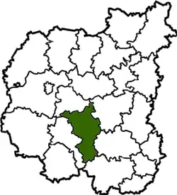
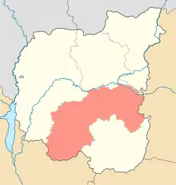 Raion location in Chernihiv Oblast | |
| Coordinates: 51°7′19″N 31°59′43″E / 51.12194°N 31.99528°E | |
| Country | |
| Oblast | |
| Admin. center | Nizhyn |
| Subdivisions | 17 hromadas |
| Area | |
• Total | 1,514 km2 (585 sq mi) |
| Population (2022)[1] | |
• Total | 215,908 |
| • Density | 140/km2 (370/sq mi) |
| Time zone | UTC+2 (EET) |
| • Summer (DST) | UTC+3 (EEST) |
| Website | http://neadm.cg.gov.ua/ |
Nizhyn Raion (Ukrainian: Ніжинський район) is a raion (district) of Chernihiv Oblast, northern Ukraine. Its administrative centre is located at Nizhyn. The area of Nizhyn Raion is located within the Dnieper Lowland, in Polissya. The leading sectors of the Nizhyn Raion economy are agriculture, food industry, and forestry. Population: 215,908 (2022 estimate).[1]
History
On 18 July 2020, as part of the administrative reform of Ukraine, the number of raions of Chernihiv Oblast was reduced to five, and the area of Nizhyn Raion was significantly expanded. Four abolished raions, Bakhmach, Bobrovytsia, Borzna, and Nosivka Raions, as well as the city of Nizhyn, which was previously incorporated as a city of oblast significance and did not belong to the raion, were merged into Nizhyn Raion.[2][3] The January 2020 estimate of the raion population was 25,716 (2020 est.).[4]
Subdivisions
Current
After the reform in July 2020, the raion consists of 17 hromadas:[3]
- Bakhmach urban hromada with the administration in the city of Bakhmach, transferred from Bakhmach Raion;[5]
- Baturyn urban hromada with the administration in the city of Baturyn, transferred from Bakhmach Raion;[5]
- Bobrovytsia urban hromada with the administration in the city of Bobrovytsia, transferred from Bobrovytsia Raion;[6]
- Borzna urban hromada with the administration in the city of Borzna, transferred from Borzna Raion;[7]
- Dmytrivka settlement hromada with the administration in the rural settlement of Dmytrivka, transferred from Bakhmach Raion;[5]
- Komarivka rural hromada with the administration in the selo of Komarivka, transferred from Borzna Raion;[7]
- Kruty rural hromada with the administration in the selo of Kruty, retained from Nizhyn Raion;
- Losynivka settlement hromada with the administration in the rural settlement of Losynivka, retained from Nizhyn Raion;
- Makiivka rural hromada with the administration in the selo of Makiivka, transferred from Nosivka Raion;[8]
- Mryn rural hromada with the administration in the selo of Mryn, transferred from Nosivka Raion;[8]
- Nizhyn urban hromada with the administration in the city of Nizhyn, was previously a city of oblast significance;[9]
- Nosivka urban hromada with the administration in the city of Nosivka, transferred from Nosivka Raion;[8]
- Nova Basan rural hromada with the administration in the selo of Nova Basan, transferred from Bobrovytsia Raion;[6]
- Plysky rural hromada with the administration in the selo of Plysky, transferred from Borzna Raion;[7]
- Talalaivka rural hromada with the administration in the selo of Talalaivka, retained from Nizhyn Raion;
- Vertiivka rural hromada with the administration in the selo of Vertiivka, retained from Nizhyn Raion;
- Vysoke rural hromada with the administration in the selo of Vysoke, transferred from Borzna Raion.[7]
Before 2020
Before the 2020 reform, the raion consisted of four hromadas:[10]
- Kruty rural hromada with the administration in Kruty;
- Losynivka settlement hromada with the administration in Losynivka;
- Talalaivka rural hromada with the administration in Talalaivka;
- Vertiivka rural hromada with the administration in Vertiivka.
Geography
Nizhyn Raion is located in the southern and central-eastern part of Chernihiv region. It borders Pryluky and Chernihiv Raions of Chernihiv Oblast and Sumy and Kyiv Oblasts.The distance to the regional center by railway is 87 km, by highways 90 km.[11][12]
The area of Nizhyn Raion is located within the Dnieper Lowland. The relief of the district's surface is a lowland plain, in places dissected by river valleys. All rivers belong to the Dnieper basin. Nizhyn Raion is located on the watershed of the Sula and Desna rivers. The largest river in the district is Oster (a left tributary of the Desna) and the Seym (left tributary of the Desna). In the floodplains of the rivers there are oxbow lake forests and lowland swamps.[13][14]
The climate of Nizhyn Raion is moderately continental, with warm summers and relatively mild winters. The average temperature in January is about -7°C, and in July - +19°C. The average annual precipitation ranges from 550 to 660 mm, with the highest amount of precipitation in the summer period.[15][14]
The soil cover of the district is dominated by chernozem and swamps soils. [16] Nizhyn Raion is located in the natural zone of the forest steppe, in Polissya. [17]The main species in the forests are oak, alder, ash, and birch. Minerals raion: peat, sand, clay.[12]
Economy
The leading sectors of the Nizhyn Raion economy are agriculture, food industry, and forestry. Agriculture specializes in growing grain and industrial crops, cattle breeding, and pig breeding.[12]
Transportation
The railway tracks of the South-Western Railway pass through the Nizhyn Raion in the direction of Chernihiv-Pryluky-Bakhmach and Hlukhiv-Kyiv. The main railway stations are Nizhyn and Bakhmach. The state highways M01 and M02 pass through the territory of the Raion.[18][12]
References
![]() Media related to Nizhynskyi Raion at Wikimedia Commons
Media related to Nizhynskyi Raion at Wikimedia Commons
- ^ a b Чисельність наявного населення України на 1 січня 2022 [Number of Present Population of Ukraine, as of January 1, 2022] (PDF) (in Ukrainian and English). Kyiv: State Statistics Service of Ukraine. Archived (PDF) from the original on 4 July 2022.
- ^ "Про утворення та ліквідацію районів. Постанова Верховної Ради України № 807-ІХ". Голос України (in Ukrainian). 2020-07-18. Retrieved 2020-10-03.
- ^ a b "Нові райони: карти + склад" (in Ukrainian). Міністерство розвитку громад та територій України. Retrieved 2021-03-17.
- ^ Чисельність наявного населення України на 1 січня 2020 року / Population of Ukraine Number of Existing as of January 1, 2020 (PDF) (in Ukrainian and English). Kyiv: State Statistics Service of Ukraine. Archived (PDF) from the original on 28 September 2023.
- ^ a b c "Бахмацька районна рада (состав до 2020 г.)" (in Russian). Портал об'єднаних громад України. Retrieved 2021-03-17.
- ^ a b "Бобровицька районна рада (состав до 2020 г.)" (in Russian). Портал об'єднаних громад України. Retrieved 2021-03-17.
- ^ a b c d "Борзнянска районна рада (состав до 2020 г.)" (in Russian). Портал об'єднаних громад України. Retrieved 2021-03-17.
- ^ a b c "Носівська районна рада (состав до 2020 г.)" (in Russian). Портал об'єднаних громад України. Retrieved 2021-03-17.
- ^ "Нежинская городская громада" (in Russian). Портал об'єднаних громад України. Retrieved 2021-03-17.
- ^ "Ніжинська районна рада (состав до 2020 г.)" (in Russian). Портал об'єднаних громад України. Retrieved 2021-03-17.
- ^ "Ніжинський район". maps.visicom.ua (in Ukrainian). Retrieved 2025-07-13.
- ^ a b c d Паспорт Ніжинського району 2025 рік Офіційний сайт Ніжинського району Retrieved 2025-07-13.
- ^ Національний атлас України/НАН України, Інститут географії, Державна служба геодезії, картографії та кадастру; голов. ред. Л. Г. Руденко; голова ред. кол.Б.Є. Патон. — К.: ДНВП «Картографія», 2007. — 435 с. — 5 тис.прим. — ISBN 978-966-475-067-4. Retrieved 2025-07-13
- ^ a b Чернігівська область. Географічний атлас. Серія «Моя мала Батьківщина» – 2003 р. ISBN 966-7620-39-5 Retrieved 2025-07-13.
- ^ "Кліматичні характеристики". Сайт Чернігівського метеоцентра. Retrieved 2025-07-13.
- ^ Білоус, М. Д. Географія Чернігівської області / М. Д. Білоус. — Чернігів: Ранок, 2010. — 144 с Retrieved 2025-07-13
- ^ Барановська О.В. та ін. Чернігівщина: природа, населення, господарство (комплексне географічне дослідження): Монографія. – Ніжин: Наука-сервіс, 2000. – 180 с. Retrieved 2025-07-13
- ^ Чернігівська область. Географічний атлас. Серія «Моя мала Батьківщина» – 2003 р. ISBN 966-7620-39-5 Retrieved 2025-07-13.
| Cities | | |
|---|---|---|
| Rural settlements | ||
| Villages |
| |
| Hromadas | ||
Chernihiv Oblast hromadas (communities) | ||
|---|---|---|
Administrative center: Chernihiv | ||
| Chernihiv Raion |   | |
| Koriukivka Raion | ||
| Novhorod-Siverskyi Raion | ||
| Pryluky Raion | Ichnia · Ladan · Lynovytsia · Mala Divytsia · Parafiivka · Pryluky · Sribne · Sukhopolova · Talalaivka · Varva · Yablunivka | |
Urban hromadas are marked in bold script. | ||