Nghĩa Đô
Nghĩa Đô Ward
Phường Nghĩa Đô | |
|---|---|
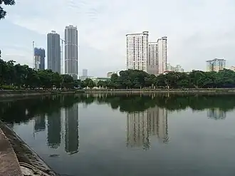
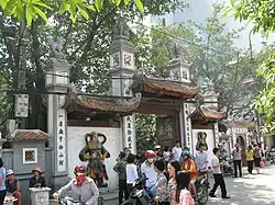
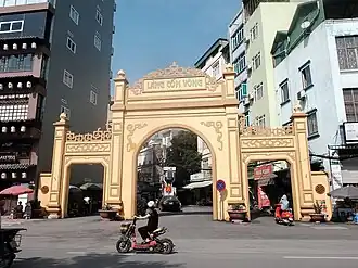
From top, left to right : Nghĩa Tân Lake, Bối Hà Communal Hall, Gate of Dịch Vọng Village, Meet and More bubble tea, and Secondhand Motorbike Market. | |
| Country | |
| Region | Red River Delta |
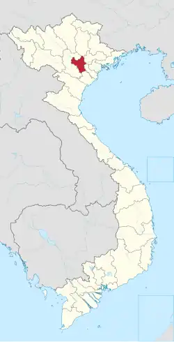
| Municipality | Hà Nội |
| Establishment | Late XVI century (commune) October 31, 1982 (township) November 22, 1996[1] (ward) |
| Central hall | No.45, Nghĩa Tân Street, Nghĩa Đô Ward[2] |
| Government | |
| • Type | Ward-level authority |
| • People Committee's Chairman | Trần Đình Cường[2] |
| • People Council's Chairman | Nguyễn Hồng Sơn[2] |
| • Front Committee's Chairman | Nguyễn Kim Lê[2] |
| • Party Committee's Secretary | Nguyễn Hồng Sơn[2] |
| Area | |
• Total | 4.34 km2 (1.68 sq mi) |
| Population (July 1, 2025)[1] | |
• Total | 125,568 |
| • Density | 28,933/km2 (74,940/sq mi) |
| • Ethnicities | Kinh Tanka Others |
| Time zone | UTC+7 (Indochina Time) |
| ZIP code | 10000–11307[note 1] |
| Climate | Cwa |
| Website | Nghiado.Hanoi.gov.vn Nghiado.Hanoi.dcs.vn |
%252C_275_Tran_Quoc_Hoan_Road%252C_Cau_Giay_District%252C_Hanoi%252C_Vietnam_(01).jpg)

Nghĩa Đô [ŋiʔiə˧˥:ɗo˧˧] is a ward of Hanoi the capital city in the Red River Delta of Vietnam.[3]
History
Its name Nghĩa Đô (義都) means "the suburbs of the capital city" in Hanese.
Middle Ages
According the time when Emperor Gia Long had just re-united the country (1802), the area of modern Nghĩa Đô Ward belonged to the sub-urban zone behind the southwest gate of Đông Kinh Citadel, but its large walls have been eroded for a long time. That was originally the territory of two communes Đoài Môn & Nghĩa Đô of Sơn Tây Garrison and Bái Ân Ward of Đông Kinh the capital city. In which, Nghĩa Đô Commune (Nghĩa Đô xã) consisted of four hamlets : Tiên Thượng (Kẻ Tân Village), Trung Nha (Kẻ Nghè V.), Vạn Long (Kẻ Dâu V.), and An Phú. All of them located in Dịch Vọng Canton, Từ Liêm Rural District, Quốc Oai Prefecture, Sơn Tây Garrison, Bắc Thành Region of the Imperial Annam.[note 2] However, during the first administrative reform of Emperor Minh Mệnh in 1831, Từ Liêm District was transferred to Hoài Đức Prefecture of Hà Nội Province.
20th century
In 1904, the Government of French Tonkin decided to transfer Hoài Đức Prefecture to Hà Đông Province. However, by December 1942, Hoài Đức was re-merged into Hà Nội Special Town.[note 3]
After the Government of the Democratic Republic of Vietnam was officially established in January 6, 1946, Nghĩa Đô was divided into two new communes Nghĩa Đô Thượng (Tân & Nghè) and Nghĩa Đô Hạ (Dâu & An Phú). They all belonged to Đại La Zone of the sub-urban Hanoi.
During the First Indochina War, the Government of Bắc Việt under the State of Vietnam has re-established Nghĩa Đô Commune as a part of Quảng Bá District, Hoàn Long Town.[note 4] On the other side, the resistance people, although not realistic, still decided to merge Nghĩa Đô and Đoài Môn to Nghĩa Môn Commune (xã Nghĩa Môn), belonging to District IV (quận 4) of the sub-urban Hanoi. Some time later, Dist. IV was renamed as Trấn Tây Rural District (huyện Trấn Tây).
After the Geneva Agreement (1954), the Government of North Vietnam merged two communes Yên Thái (including former Bái Ân Ward) and Nghĩa Môn to become Thái Đô Commune (xã Thái Đô), belonging to District V (quận 5). However, They were separated again in 1961 : Yên Thái Village belonged to Ba Đình Urban District, and Nghĩa Đô Commune under Từ Liêm Rural District.
In October 31, 1982, Nghĩa Đô Township (thị trấn Nghĩa Đô) was established to serve as the capital of Từ Liêm Rural District. This new administrative unit included old Nghĩa Đô Commune and the VOV Collective Quarter.[note 5] By 1992, the collective quarter has been separated to become Nghĩa Tân Township (thị trấn Nghĩa Tân).[4] In November 22, 1996, when Cầu Giấy Urban District (quận Cầu Giấy) was established, both Nghĩa Đô and Nghĩa Tân became its ward-level administrative units.[5]
21st century
In April 19, 2025, to realize the project to arrange and merge administrative units by the Government of Vietnam, the Hà Nội City People's Committee quickly approved a Resolution on the plan of re-arranging commune+ward-level administrative units in the whole city.[6]
According to the political document published for the press in the same day, Cầu Giấy District was officially dissolved. Its entire area and population have been divided into three new wards Cầu Giấy 1 (Cầu Giấy), Cầu Giấy 2 (Nghĩa Đô), and Cầu Giấy 3 (Yên Hòa). Therefore, new Nghĩa Đô Ward (phường Nghĩa Đô) has been established based on the merging of :
- The small parts of three former wards Cổ Nhuế 1 & Xuân Tảo from Bắc Từ Liêm District and Xuân La from Tây Hồ District.
- The big parts of six former wards from Cầu Giấy District what includes Dịch Vọng, Dịch Vọng Hậu, Mai Dịch, Nghĩa Đô, Nghĩa Tân, and Quan Hoa.
Overall, the new administrative unit basically has the meaning of preserving the cultural and historical values of before Nghĩa Đô Commune, where is said to have appeared since the 16th century as a combination of migrant groups from Thanh Hoa Garrison and some indigenous people from Hạ Yên Quyết Village.[7]
-
 Plan to establish commune-level administrative units...
 -
 ... within Cầu Giấy Rural District in 2025.
 -
 Detail map of three new wards Nghĩa Đô, Cầu Giấy, and Yên Hòa.
Geography
Demography
According to the statistical yearbook of the whole Hanoi, as of 2025 Nghĩa Đô Ward had a population of 125,568.[1] Besides, the population of the whole ward is fully registered as Kinh people.
Climate
| Climate data for Nghĩa Đô Ward | |||||||||||||
|---|---|---|---|---|---|---|---|---|---|---|---|---|---|
| Month | Jan | Feb | Mar | Apr | May | Jun | Jul | Aug | Sep | Oct | Nov | Dec | Year |
| Record high °C (°F) | 33.3 (91.9) |
35.1 (95.2) |
37.2 (99.0) |
41.5 (106.7) |
42.8 (109.0) |
41.8 (107.2) |
40.8 (105.4) |
39.7 (103.5) |
37.4 (99.3) |
36.6 (97.9) |
36.0 (96.8) |
31.9 (89.4) |
42.8 (109.0) |
| Mean daily maximum °C (°F) | 19.8 (67.6) |
20.6 (69.1) |
23.2 (73.8) |
27.7 (81.9) |
31.9 (89.4) |
33.4 (92.1) |
33.4 (92.1) |
32.6 (90.7) |
31.5 (88.7) |
29.2 (84.6) |
25.7 (78.3) |
22.0 (71.6) |
27.6 (81.7) |
| Daily mean °C (°F) | 16.6 (61.9) |
17.7 (63.9) |
20.3 (68.5) |
24.2 (75.6) |
27.6 (81.7) |
29.3 (84.7) |
29.4 (84.9) |
28.7 (83.7) |
27.7 (81.9) |
25.3 (77.5) |
21.9 (71.4) |
18.3 (64.9) |
23.9 (75.0) |
| Mean daily minimum °C (°F) | 14.5 (58.1) |
15.8 (60.4) |
18.4 (65.1) |
21.9 (71.4) |
24.8 (76.6) |
26.4 (79.5) |
26.5 (79.7) |
26.1 (79.0) |
25.2 (77.4) |
22.8 (73.0) |
19.3 (66.7) |
15.8 (60.4) |
21.5 (70.7) |
| Record low °C (°F) | 2.7 (36.9) |
5.0 (41.0) |
7.0 (44.6) |
9.8 (49.6) |
15.4 (59.7) |
20.0 (68.0) |
21.0 (69.8) |
20.9 (69.6) |
16.1 (61.0) |
12.4 (54.3) |
6.8 (44.2) |
5.1 (41.2) |
2.7 (36.9) |
| Average rainfall mm (inches) | 22.5 (0.89) |
24.6 (0.97) |
47.0 (1.85) |
91.8 (3.61) |
185.4 (7.30) |
253.3 (9.97) |
280.1 (11.03) |
309.4 (12.18) |
228.3 (8.99) |
140.7 (5.54) |
66.7 (2.63) |
20.2 (0.80) |
1,670.1 (65.75) |
| Average rainy days | 9.5 | 11.4 | 15.9 | 13.7 | 14.6 | 14.8 | 16.6 | 16.5 | 13.2 | 9.7 | 6.8 | 5.2 | 147.9 |
| Average relative humidity (%) | 79.9 | 82.5 | 84.5 | 84.7 | 81.1 | 80.0 | 80.7 | 82.7 | 81.0 | 78.5 | 77.1 | 76.2 | 80.7 |
| Mean monthly sunshine hours | 68.7 | 48.1 | 45.5 | 87.4 | 173.7 | 167.0 | 181.1 | 163.0 | 162.4 | 150.3 | 131.6 | 113.0 | 1,488.5 |
| Source 1: Vietnam Institute for Building Science and Technology[8] | |||||||||||||
| Source 2: Extremes[a] | |||||||||||||
See also
Notes and references
Notes
References
- ^ a b c Nghĩa Đô Ward – All instruction information you need to know (vi)
- ^ a b c d e Nghĩa Đô Ward : Detailed information after arrangement (vi)
- ^ Phường Nghĩa Đô sau sắp xếp đơn vị hành chính sẵn sàng phục vụ và chủ động triển khai nhiệm vụ
- ^ Tập thể cũ lưu giữ ký ức Hà Nội
- ^ Phường Nghĩa Tân quận Cầu Giấy được đề xuất điều chỉnh địa giới hành chính như thế nào ?
- ^ Ba phường mới ở quận Cầu Giấy được đặt trụ sở tại đâu sau sắp xếp ?
- ^ All of Nghĩa Đô Commune (vi)
- ^ "Vietnam Institute for Building Science and Technology" (PDF).
- ^ "Hà Nội nóng kỉ lục 41.5 độ". DanViet.vn (in Vietnamese). Archived from the original on 3 June 2017. Retrieved 4 June 2017.
- ^ "THÔNG BÁO VÀ DỰ BÁO KHÍ HẬU MÙA X, XI, XII NĂM 2019" (PDF). imh.ac.vn (in Vietnamese). Archived (PDF) from the original on 5 August 2022. Retrieved 6 August 2022.
- ^ "THỜI TIẾT HÀ NỘI". nchmf.gov.vn (in Vietnamese). Archived from the original on 29 September 2018. Retrieved 30 September 2018.
- ^ "VIỆT NAM NIÊN GIÁM THỐNG KÊ" (PDF). Southeast Asian Development. Archived from the original (PDF) on 10 May 2021. Retrieved 24 May 2022.
- ^ The Yearbook of Indochina (1932–33)
Further reading
Bibliography
- George Coedes. The Making of South East Asia, 2nd ed. University of California Press, 1983.
- Trần Ngọc Thêm. Cơ sở văn hóa Việt Nam (The Foundation of Vietnamese Culture), 504 pages. Publishing by Nhà xuất bản Đại học Tổng hợp TPHCM. Saigon, Vietnam, 1995.
- Philippe Papin, Histoire de Hanoï, Fayard, Paris, 2001.
- Trần Quốc Vượng, Tô Ngọc Thanh, Nguyễn Chí Bền, Lâm Mỹ Dung, Trần Thúy Anh. Cơ sở văn hóa Việt Nam (The Basis of Vietnamese Culture), 292 pages. Re-publishing by Nhà xuất bản Giáo Dục Việt Nam & Quảng Nam Printing Co-Ltd. Hanoi, Vietnam, 2006.
- Li Tana (2011). Jiaozhi (Giao Chỉ) in the Han period Tongking Gulf. In Cooke, Nola ; Li Tana ; Anderson, James A. (eds.). The Tongking Gulf Through History. University of Pennsylvania Press. pp. 39–44. ISBN 9780812205022.
- Tập bản đồ hành chính Việt Nam (Vietnamese Administrative Maps), Nhà xuất bản Tài nguyên – Môi trường và Bản đồ Việt Nam, Hà Nội, 2013.
- Li Tana, Towards an environmental history of the Eastern Red River Delta, Vietnam, c.900–1400, Journal of Southeast Asian Studies, 2014.
- Samuel Baron, Christoforo Borri, Olga Dror, Keith W. Taylor (2018). Views of Seventeenth-Century Vietnam : Christoforo Borri on Cochinchina and Samuel Baron on Tonkin. Cornell University Press. ISBN 978-1-501-72090-1.
- The Birth of Vietnam : Sino-Vietnamese Relations to the Tenth Century and the Origins of Vietnamese Nationhood. University of Michigan Press. 1976.
- Taylor, Keith Weiler (1983). The Birth of Vietnam. Berkeley, California: University of California Press. doi:10.2307/jj.8501140. ISBN 978-0-52007-417-0. JSTOR jj.8501140. LCCN 81011590. OCLC 1131176955. S2CID 265239427.
- Taylor, K. W.; Whitmore, John K., eds. (1995). Essays Into Vietnamese Pasts. Ithaca, New York: Cornell University Southeast Asia Program. doi:10.7591/9781501718991. ISBN 978-0-87727-718-7. JSTOR 10.7591/j.ctv1nhmtn. OCLC 1091450831.
- Borri, Christoforo; Baron, Samuel (2006). Views of Seventeenth-Century Vietnam : Christoforo Borri on Cochinchina and Samuel Baron on Tonkin. Ithaca, New York: Cornell University Press. doi:10.7591/9781501720901. ISBN 978-0-87727-771-2. JSTOR 10.7591/j.ctv3s8qt9. LCCN 2009280899. OCLC 1262600216. S2CID 160903627.
- Taylor, K. W. (2013). A History of the Vietnamese. Cambridge: Cambridge University Press. doi:10.1017/CBO9781139021210. ISBN 978-1-107-24435-1. LCCN 2012035197. OCLC 843761714. S2CID 161759966.
- Pierre Asselin, Pierre Brocheux, Christopher E. Goscha, Pierre Grosser, Annick Guénel, François Guillemot, Andrew Hardy, Michel Hoàng, Pierre Journoud, Anne Marie Moulin, Philippe Papin, Emmanuel Poisson, Dominique Rolland, Hugues Tertrais, Benoît de Tréglodé..., Le Viêt-Nam depuis 2000 ans, De La Republique Eds, Paris, 2017.
External links
- Hanoi province and its subdivisions
- Dự kiến tên gọi các phường–xã được thành lập ở Hà Nội
- 876 cán bộ công chức ở Hà Nội xin nghỉ việc khi sắp xếp đơn vị hành chính cấp xã
- Hiện trạng hai khu tập thể cũ ở Hà Nội dự kiến cải tạo thành cao ốc từ 40 tầng
- Toàn cảnh khu tập thể Nghĩa Tân sắp được cải tạo và xây mới
- Quyền lợi của người dân khi cải tạo hoặc xây dựng lại khu tập thể Nghĩa Tân
- Khu tập thể Nghĩa Tân xuống cấp nhưng vẫn ưu tiên đào đường, Sở Xây Dựng giải thích
| Wards (51) |
|  |
|---|---|---|
| Communes (75) |
| |