Đông Ngạc
Đông Ngạc Ward
Phường Đông Ngạc Xã Đông Ngạc Làng Cổ Nhuế | |
|---|---|
From top, left to right : Thụy Phương Communal Hall, Minh Khai Station, and Thăng Long Bridge. | |
| Nickname(s): "Trèm–Vẽ Bund" (Bến Trèm–Vẽ) | |
| Country | |
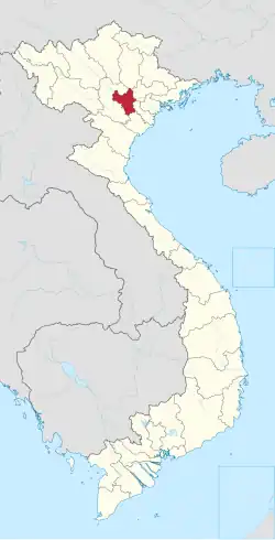
| Region | Red River Delta |
| Municipality | Hà Nội |
| Establishment | IX century (village) 2013 (ward) |
| Central hall | No.1, Vân Hội Street, Resident Group No.2, Đông Ngạc Ward[1] |
| Government | |
| • Type | Ward-level authority |
| • People Committee's Chairman | Nguyễn Văn Hách[1] |
| • People Council's Chairman | Ngô Văn Nam[1] |
| • Front Committee's Chairman | Nguyễn Thanh Nhàn[1] |
| • Party Committee's Secretary | Ngô Văn Nam[1] |
| Area | |
• Total | 8.85 km2 (3.42 sq mi) |
| Population (July 1, 2025)[1] | |
• Total | 83,544 |
| • Density | 9,400/km2 (24,000/sq mi) |
| • Ethnicities | Kinh Tanka Others |
| Time zone | UTC+7 (Indochina Time) |
| ZIP code | 10000–11909[note 1] |
| Climate | Cwa |
| Website | Dongngac.Hanoi.gov.vn Dongngac.Hanoi.dcs.vn |
Đông Ngạc [o˧˧:ʨə̰ːʔ˨˩:zɨ̤ə˨˩] is a ward of Hanoi the capital city in the Red River Delta of Vietnam.[2]
History
Its name Đông Ngạc (Hanese: 東鄂) was interpreted by the Hanoi City People's Committee[note 2] as the preservation of cultural, historical and traditional values in the Northwest area of the urban Hanoi. This also helps to minimize negative impacts on citizens and businesses when needing to convert legal documents.[1]
Middle Ages
The area of Đông Ngạc Ward has long been known as the oldest village-level administrative unit in Hanoi. According to Từ điển Hà Nội - Địa danh by Bùi Thiết,[note 3] Cổ Nhuế Village (làng Cổ Nhuế) has existed since at least before the Lý Dynasty. The book also said that Cổ Nhuế (which is similar to Cổ Loa and Cổ Pháp) was just a Hanese spelling, but its common name was K'noi or Kẻ Noi in reality. This Middle-age Annamese word means "nose", which described the geographical location of the land, where two rivers Hồng and Nhuệ meet.
For about a thousand years under the monarchy, Kẻ Noi was the domain of Xuân Tảo Canton, Hoài Đức Prefecture, Sơn Tây Garrison (under Revival Lê Dynasty), then Sơn Tây Province (under Nguyễn Dynasty).
20th century
In 1941, the Government of Tonkin decided to abolish the canton-level, thus making Cổ Nhuế Commune (xã Cổ Nhuế) part of Từ Liêm Rural District, Hà Đông Province. By 1945, Cổ Nhuế had been divided into three communes Trù Đống (Kẻ Chèm),[note 4] Hoàng (Kẻ Noi), Viên (Kẻ Vẽ) to become the outskirts of Hanoi City. They were considered part of District 5.
In the winter war of 1946, after the clash at Sova Shop, the Vietnam National Defense Army quickly formed a mixed troop to block the French tank column attacking urban Hanoi from the direction of Trèm–Vẽ. These amateur gunmen were somewhat successful in holding off the French for the next two months.[note 5][note 6]
By 1961, the three communes were re-merged as Đức Thắng Commune (xã Đức Thắng) to become part of Từ Liêm Rural District. Name Đông Ngạc began to appear as an alternative reading of Trù Đống and Cổ Nhuế. Therefore, Đức Thắng was changed to Đông Ngạc Commune (xã Đông Ngạc) in 1964.
21st century
In 2013, Từ Liêm Rural District was dissolved. Đông Ngạc became a ward of Bắc Từ Liêm Urban District.
According to Project No. 369/ĐA-CP dated May 9, 2025 of the Government of Vietnam on the arrangement of commune-level administrative units in the Hanoi Capital Area 2025, new Đông Ngạc Ward (phường Đông Ngạc) was founded on natural and population conditions from former wards, as follows : Cổ Nhuế 2, old Đông Ngạc, Đức Thắng, Minh Khai, Thụy Phương, Xuân Đỉnh.[1]
Culture
Customs
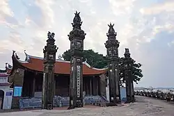
According to middle-age documents in Hanese characters, the area of Đông Ngạc Ward used to include three hamlets Đống, Hoàng, and Trù. Later, for convenience, folks often called this area as Trèm–Vẽ Bund (bến Trèm–Vẽ).[3] This place has the largest pagoda system in the Northern Vietnam, which was certified by the honorary certificates (sắc phong) granted by the dynasties.[note 7]
Cổ Nhuế Parish (giáo xứ Cổ Nhuế) received the Gospel in 1883.[4] The parish's largest church was built in 1884 and has survived several fires and lootings.
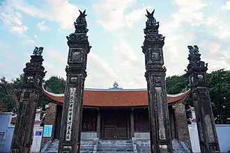
In 1990, Thụy Phương Temple (or Thụy Phương Communal Hall, or Trèm Temple) was ranked by the Government of Vietnam as a special national historical relic for its aesthetic and spiritual elements.[5]
-
 1930
1930 -
 2022
2022
According to legend, in 1915, during the reign of Emperor Duy Tân, Liên Mạc Dike broke, causing rice yields to become very low, so the Kẻ Trèm villagers came up with the idea of growing corn to fight hunger. This corn was quickly brought to Hanoi for sale and became famous for its stickiness and aroma. However, by 1920, the agricultural situation was declining, and most villagers had turned to tailoring. Since 1935, Đông Ngạc tailors have almost completely dominated Hàng Trống Street.
Notable persons
Hoàng Clan is the largest family in Đông Ngạc and also has a very long tradition of examinations. Their forefathers were Nungz people who migrated from Lạng Sơn Province. Since royal official Hoàng Huân Trung (1877 - 1950), his children have become prominent figures in Vietnamese politics.

- (Madame) Hoàng Thị Nga (1903 - 1970) : French-Vietnamese PhD in Physics.
- Hoàng Cơ Bình (1909 - 1988) : Writer, dentist, candidate of the South Vietnamese presidential elections 1967 and 1971.
- Hoàng Cơ Thụy (1912 - 2004) : Lawyer, South Vietnamese ambassador in the Kingdom of Laos.
- Hoàng Cơ Long : American-Vietnamese lawyer.
- Hoàng Cơ Nghị : Bachelor of Physics, professor of the College of the Protectorate.
- Hoàng Cơ Minh (1935 - 1987) : Vice admiral of the Republic of Vietnam Navy, chairman of the National United Front for the Liberation of Vietnam.
- Hoàng Cơ Trường : Medico, captain of the Republic of Vietnam Marine Division.
- Hoàng Cơ Định : PhD in Chemistry, Director of Chemistry Department of the Phú Thọ National Center of Technique, leader of the Vietnam Reform Revolutionary Party.
Besides, this is also the birthplace of Văn Tiến Dũng, a general of People's Army of Vietnam. He was ever a weaver.
Geography
Climate
| Climate data for Đông Ngạc Ward | |||||||||||||
|---|---|---|---|---|---|---|---|---|---|---|---|---|---|
| Month | Jan | Feb | Mar | Apr | May | Jun | Jul | Aug | Sep | Oct | Nov | Dec | Year |
| Record high °C (°F) | 33.3 (91.9) |
35.1 (95.2) |
37.2 (99.0) |
41.5 (106.7) |
42.8 (109.0) |
41.8 (107.2) |
40.8 (105.4) |
39.7 (103.5) |
37.4 (99.3) |
36.6 (97.9) |
36.0 (96.8) |
31.9 (89.4) |
42.8 (109.0) |
| Mean daily maximum °C (°F) | 19.8 (67.6) |
20.6 (69.1) |
23.2 (73.8) |
27.7 (81.9) |
31.9 (89.4) |
33.4 (92.1) |
33.4 (92.1) |
32.6 (90.7) |
31.5 (88.7) |
29.2 (84.6) |
25.7 (78.3) |
22.0 (71.6) |
27.6 (81.7) |
| Daily mean °C (°F) | 16.6 (61.9) |
17.7 (63.9) |
20.3 (68.5) |
24.2 (75.6) |
27.6 (81.7) |
29.3 (84.7) |
29.4 (84.9) |
28.7 (83.7) |
27.7 (81.9) |
25.3 (77.5) |
21.9 (71.4) |
18.3 (64.9) |
23.9 (75.0) |
| Mean daily minimum °C (°F) | 14.5 (58.1) |
15.8 (60.4) |
18.4 (65.1) |
21.9 (71.4) |
24.8 (76.6) |
26.4 (79.5) |
26.5 (79.7) |
26.1 (79.0) |
25.2 (77.4) |
22.8 (73.0) |
19.3 (66.7) |
15.8 (60.4) |
21.5 (70.7) |
| Record low °C (°F) | 2.7 (36.9) |
5.0 (41.0) |
7.0 (44.6) |
9.8 (49.6) |
15.4 (59.7) |
20.0 (68.0) |
21.0 (69.8) |
20.9 (69.6) |
16.1 (61.0) |
12.4 (54.3) |
6.8 (44.2) |
5.1 (41.2) |
2.7 (36.9) |
| Average rainfall mm (inches) | 22.5 (0.89) |
24.6 (0.97) |
47.0 (1.85) |
91.8 (3.61) |
185.4 (7.30) |
253.3 (9.97) |
280.1 (11.03) |
309.4 (12.18) |
228.3 (8.99) |
140.7 (5.54) |
66.7 (2.63) |
20.2 (0.80) |
1,670.1 (65.75) |
| Average rainy days | 9.5 | 11.4 | 15.9 | 13.7 | 14.6 | 14.8 | 16.6 | 16.5 | 13.2 | 9.7 | 6.8 | 5.2 | 147.9 |
| Average relative humidity (%) | 79.9 | 82.5 | 84.5 | 84.7 | 81.1 | 80.0 | 80.7 | 82.7 | 81.0 | 78.5 | 77.1 | 76.2 | 80.7 |
| Mean monthly sunshine hours | 68.7 | 48.1 | 45.5 | 87.4 | 173.7 | 167.0 | 181.1 | 163.0 | 162.4 | 150.3 | 131.6 | 113.0 | 1,488.5 |
| Source 1: Vietnam Institute for Building Science and Technology[6] | |||||||||||||
| Source 2: Extremes[a] | |||||||||||||
See also
- Hồng Hà
- Nghĩa Đô
- Phú Diễn
- Phú Thượng
- Tây Hồ
- Tây Tựu
- Thiên Lộc
- Thượng Cát
- Xuân Đỉnh
Notes and references
Notes
- ^ An official code from December 31, 2023, to present.
- ^ Từ ngày 1/7/2025, thành phố Hà Nội chính thức đưa vào hoạt động 126 đơn vị hành chính cấp xã, phường mới theo Nghị quyết số 1656/NQ-UBTVQH15 của Ủy ban Thường vụ Quốc hội.
- ^ Bùi Thiết, Từ điển Hà Nội - Địa danh (Hanoi dictionary - Place names), Văn Hóa Thông Tin Publishing, Hanoi, 1993.
- ^ By ideas of researchers Tạ Chí Đại Trường and Nguyễn Hùng Vỹ, words "cửu-diên", "cửu-liên", "mạc-liên", "từ-liêm" are the Hanese ways of the phonetic for "k'len", "t'len" or "sen" (originated from Sanskrit "kamala" कमल) in ancient Annamese language, which mean "lotus [bund]".
- ^ Mai Thảo, Đêm giả từ Hà Nội (Farewell Night of Hanoi), Người Việt Publishing, Saigon, 1955.
- ^ Nguyễn Huy Tưởng, Sống mãi với thủ đô (Living Forever With the Capital), Văn Học Publishing, Hanoi, 1961.
- ^ Lê Trung Vũ, Lễ hội Thăng Long (Festivals in Thăng Long), Hanoi Publishing, 2001.
References
- ^ a b c d e f g h Đông Ngạc Ward : Detailed information after arrangement (vi)
- ^ Quận Bắc Từ Liêm (cũ) TP Hà Nội sau sắp xếp đơn vị hành chính gồm những phường nào ?
- ^ Đất Kẻ Giàn Quan Kẻ Vẽ
- ^ Cổ Nhuế Parish 1 2
- ^ Đình Trèm - Ngôi đình cổ xưa, di sản quý báu của thủ đô
- ^ "Vietnam Institute for Building Science and Technology" (PDF).
- ^ "Hà Nội nóng kỷ lục 41.5 độ". danviet.vn (in Vietnamese). Archived from the original on 3 June 2017. Retrieved 4 June 2017.
- ^ "THÔNG BÁO VÀ DỰ BÁO KHÍ HẬU MÙA X, XI, XII NĂM 2019" (PDF). imh.ac.vn (in Vietnamese). Archived (PDF) from the original on 5 August 2022. Retrieved 6 August 2022.
- ^ "THỜI TIẾT HÀ NỘI". nchmf.gov.vn (in Vietnamese). Archived from the original on 29 September 2018. Retrieved 30 September 2018.
- ^ "VIỆT NAM NIÊN GIÁM THỐNG KÊ" (PDF). Southeast Asian Development. Archived from the original (PDF) on 10 May 2021. Retrieved 24 May 2022.
- ^ The Yearbook of Indochina (1932–33)
Further reading
Bibliography
- Đan Sơn (1735 – ?), Sơn-cư tạp-chí (山居雜誌), Đông Kinh, Bắc Hà, An Nam, 1786–9.
- George Coedes. The Making of South East Asia, 2nd ed. University of California Press, 1983.
- Trần Ngọc Thêm. Cơ sở văn hóa Việt Nam (The Foundation of Vietnamese Culture), 504 pages. Publishing by Nhà xuất bản Đại học Tổng hợp TPHCM. Saigon, Vietnam, 1995.
- Philippe Papin, Histoire de Hanoï, Fayard, Paris, 2001.
- Trần Quốc Vượng, Tô Ngọc Thanh, Nguyễn Chí Bền, Lâm Mỹ Dung, Trần Thúy Anh. Cơ sở văn hóa Việt Nam (The Basis of Vietnamese Culture), 292 pages. Re-publishing by Nhà xuất bản Giáo Dục Việt Nam & Quảng Nam Printing Co-Ltd. Hanoi, Vietnam, 2006.
- Li Tana (2011). Jiaozhi (Giao Chỉ) in the Han period Tongking Gulf. In Cooke, Nola ; Li Tana ; Anderson, James A. (eds.). The Tongking Gulf Through History. University of Pennsylvania Press. pp. 39–44. ISBN 9780812205022.
- Tập bản đồ hành chính Việt Nam (Vietnamese Administrative Maps), Nhà xuất bản Tài nguyên – Môi trường và Bản đồ Việt Nam, Hà Nội, 2013.
- Li Tana, Towards an environmental history of the Eastern Red River Delta, Vietnam, c.900–1400, Journal of Southeast Asian Studies, 2014.
- Samuel Baron, Christoforo Borri, Olga Dror, Keith W. Taylor (2018). Views of Seventeenth-Century Vietnam : Christoforo Borri on Cochinchina and Samuel Baron on Tonkin. Cornell University Press. ISBN 978-1-501-72090-1.
- The Birth of Vietnam : Sino-Vietnamese Relations to the Tenth Century and the Origins of Vietnamese Nationhood. University of Michigan Press. 1976.
- Taylor, Keith Weiler (1983). The Birth of Vietnam. Berkeley, California: University of California Press. doi:10.2307/jj.8501140. ISBN 978-0-52007-417-0. JSTOR jj.8501140. LCCN 81011590. OCLC 1131176955. S2CID 265239427.
- Taylor, K. W.; Whitmore, John K., eds. (1995). Essays Into Vietnamese Pasts. Ithaca, New York: Cornell University Southeast Asia Program. doi:10.7591/9781501718991. ISBN 978-0-87727-718-7. JSTOR 10.7591/j.ctv1nhmtn. OCLC 1091450831.
- Borri, Christoforo; Baron, Samuel (2006). Views of Seventeenth-Century Vietnam: Christoforo Borri on Cochinchina and Samuel Baron on Tonkin. Ithaca, New York: Cornell University Press. doi:10.7591/9781501720901. ISBN 978-0-87727-771-2. JSTOR 10.7591/j.ctv3s8qt9. LCCN 2009280899. OCLC 1262600216. S2CID 160903627.
- Taylor, K. W. (2013). A History of the Vietnamese. Cambridge: Cambridge University Press. doi:10.1017/CBO9781139021210. ISBN 978-1-107-24435-1. LCCN 2012035197. OCLC 843761714. S2CID 161759966.
- Pierre Asselin, Pierre Brocheux, Christopher E. Goscha, Pierre Grosser, Annick Guénel, François Guillemot, Andrew Hardy, Michel Hoàng, Pierre Journoud, Anne Marie Moulin, Philippe Papin, Emmanuel Poisson, Dominique Rolland, Hugues Tertrais, Benoît de Tréglodé..., Le Viêt-Nam depuis 2000 ans, De La Republique Eds, Paris, 2017.
External links
- Hanoi province and its subdivisions
- Dự kiến tên gọi các phường–xã được thành lập ở Hà Nội
- 876 cán bộ công chức ở Hà Nội xin nghỉ việc khi sắp xếp đơn vị hành chính cấp xã
| Wards (51) |
|  |
|---|---|---|
| Communes (75) |
| |