2025 Washington wildfires
| 2025 Washington wildfires | |
|---|---|
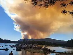 Hope Fire smoke plume over the Columbia River | |
| Date(s) | June 2025 – present |
| Season | |
← 2024 | |
The 2025 Washington wildfire season is an ongoing series of wildfires in the U.S. state of Washington.
Background
While the typical "fire season" in Washington varies every year based on weather conditions, most wildfires occur in between July and October.[1] However, hotter, drier conditions can allow wildfires to start outside of these boundaries. Wildfires tend to start at these times of the year after moisture from winter and spring precipitation dries up. Vegetation and overall conditions are the hottest and driest in these periods. The increase of vegetation can make the fires spread easier.[2]
Events
Predictions for the 2024 fire season made by the National Interagency Fire Center in May 2025 included above normal fire danger across the entire state of Washington by August, one of only two U.S. states so predicted (the other was Oregon).[3] The Washington State Department of Natural Resources stated that the 2025 fire season could begin as soon as June.[4]
The Red Bridge Fire near Cle Elum burned 60 acres (24 ha) by June 9, including two structures.[5] Immediate evacuations were ordered on June 9.[6]
A fire in the Tumwater Canyon of the Wenatchee River closed U.S. Highway 2 on June 10.[7]

"Go now" evacuations from Copper Creek/Staircase area due to Bear Gulch Fire were ordered on July 30.[8] Staircase Campground was ordered evacuated on July 31.[9] Haze from the fire reached Seattle and other Puget Sound communities the same week.[10] The fire caused unhealthy air conditions in Bellevue on August 4.[11] On August 12, the fire caused pyrocumulus clouds to form,[12] and darkened the skies around the central Puget Sound area, including Seattle.[13]
List of wildfires
The following is a list of fires that burned more than 1,000 acres (400 ha), or produced significant structural damage or casualties.
| Name | County | Acres | Start date | Containment date[a] | Notes | Ref |
|---|---|---|---|---|---|---|
| Firewater | Yakima | 3,820 | June 8 | June 9 | ||
| Vansycle Canyon | Walla Walla | 2,026 | June 12 | June 14 | [15] | |
| Pomas | Chelan | 3,468 | June 13 | Lightning-caused. Burning about 36 miles (58 km) northwest of Entiat. | [16] | |
| Barstow | Walla Walla | 1,543 | June 22 | June 25 | Burned in brush and grass, and threatened crops near Prescott. | [17][18] |
| Apple Acres | Chelan | 3,410 | July 2 | Human-caused. Burning 5 miles (8.0 km) south of Pateros. Restricted U.S. Route 97 to alternating traffic. | [19][20] | |
| Bear Gulch Fire | Mason | 8,257 | July 6 | Human-caused, near Lake Cushman | [21][22] | |
| Hope | Stevens | 8,177 | July 8 | Under investigation. Burning 10 mi (16 km) SW of Northport | [23][24] | |
| Western Pines | Lincoln | 5,781 | July 9 | July 18 | Human-caused. Burned 10 miles (16 km) north of Davenport. Destroyed 21 homes and 26 outbuildings. | [25][26] |
| Boundary Road | Yakima | 1,210 | July 15 | July 17 | Human-caused. Burned 30 miles (48 km) southeast of Toppenish. | [27] |
| Burdoin | Klickitat | 10,675 | July 18 | Undetermined cause. Burning 5 miles (8.0 km) west of Lyle and has destroyed numerous residential structures. | [28][29] | |
| Lake Spokane | Stevens | 2,550 | July 18 | Human-caused. Burned north of Spokane near Spokane Lake and U.S. Route 395. Two residential structures burned as of July 22 | [30][31] | |
| Central Ferry | Whitman | 6,597 | August 13 | Caused by a motorhome fire. Burning 26 miles (42 km) west of Pullman and prompting Level 2 evacuations. Closed State Route 127. | [32][33] |
Notes
- ^ Containment means that fire crews have established and secured control lines around the fire's perimeter. These lines are artificial barriers, like trenches or cleared vegetation, designed to stop the fire's spread, or natural barriers like rivers. Containment reflects progress in managing the fire but does not necessarily mean the fire is starved of fuel, under control, or put out.[14]
References
- ^ "Wildfire". mil.wa.gov. Emergency Management Division of Washington. Retrieved April 26, 2025.
- ^ Swanson, Conrad (August 19, 2023). "WA's wildfire seasons will last longer, cut deeper". The Seattle Times. Retrieved April 26, 2025.
- ^ "National Significant Wildland Fire Potential Outlook". Official website. National Interagency Fire Center Predictive Services. May 1, 2025.
- ^ Raile, Davis (May 2, 2025). "Washington State prepares for above-average wildfire season". Yakima, Washington and Tri-Cities, Washington: KNDO/KNDU NonStop News.
- ^ "'Red Bridge Fire' near Cle Elum likely human-caused, fire officials say". Seattle: KING-TV. June 9, 2025.
- ^ Wixey, Will (June 9, 2025). "Wildfire breaks out near Cle Elum, evacuation orders in place". Tacoma: KCPQ.
- ^ Sullivan, Olivia (June 10, 2025). "Crews contain wildfire near Leavenworth". Seattle: KING-TV.
- ^ "Level 3 evacuations remain in place for Bear Gulch Fire in Mason County, WA". KCPQ. 2025-07-30. Retrieved 2025-07-30.
- ^ "Bear Gulch Fire grows to nearly 2,000 acres". Seattle: KIRO-TV. July 31, 2025.
- ^ https://mynorthwest.com/local/bear-gulch-fire-puget-sound/4115142
- ^ Mellits, Mara (August 4, 2025). "'Unhealthy' wildfire smoke billows into Seattle, Bellevue". The Seattle Times.
- ^ Morgan Palmer (August 12, 2025). "Bear Gulch wildfire smoke creates its own cloud formation". Seattle: KIRO-TV.
- ^ "Smoke from Bear Gulch Fire creates hazy sunset across Puget Sound". Seattle: KING-TV. August 13, 2025 – via MSN.
- ^ "What containment and other wildfire related terms mean". Los Angeles: KCAL-TV. September 12, 2024. Retrieved 2025-07-25.
- ^ "VANSCYCLE CANYON - Wildfire and Smoke Map". data.elpasotimes.com. Retrieved June 20, 2025.
- ^ "POMAS - Wildfire and Smoke Map". data.sctimes.com. Retrieved June 23, 2025.
- ^ "Walla Walla County fire threatens crops and conservation land". KNDO. Retrieved June 23, 2025.
- ^ "BARSTOW ROAD - Wildfire and Smoke Map". data.dailycommerical.com. Retrieved June 24, 2025.
- ^ "APPLE ACRES - Wildfire and Smoke Map". data.independentmail.com. Retrieved July 3, 2025.
- ^ Uyehara, Kai (July 3, 2025). "2,000-acre brush fire burns between Chelan and Okanogan counties". The Seattle Times. Retrieved July 3, 2025.
- ^ "Human-caused Bear Gulch Fire remains 0% contained as crews bolster efforts". Seattle: KOMO News. July 13, 2025.
- ^ "Bear Gulch Fire". Inciweb fire information system. U.S. Government interagency National Wildfire Coordinating Group. Retrieved 2025-08-14.
- ^ Rattner, Mark; Depping, Meridith (July 8, 2025). "State Fire Mobilization authorized for the 3,000 acre Hope Fire". KHQ. Spokane, Washington. Retrieved July 9, 2025.
- ^ "HOPE - Wildfire and Smoke Map". data.lansingstatejournal.com. Retrieved July 17, 2025.
- ^ "WESTERN PINES - Wildfire and Smoke Map". data.usatoday.com. Retrieved July 10, 2025.
- ^ "Officials: Western Pines Fire Near Lake Roosevelt Has Destroyed 21 Homes, 47 Structures Total Since Ignition". Your Source One. July 14, 2025. Retrieved August 6, 2025.
- ^ "BOUNDARY ROAD - Wildfire and Smoke Map". data.usatoday.com. Retrieved July 17, 2025.
- ^ "BURDOIN - Wildfire and Smoke Map". data.redding.com. Retrieved July 19, 2025.
- ^ "Burdoin Fire". inciweb.wildfire.gov. 2025-07-20. Retrieved 2025-07-23.
- ^ "Smoke 'thick as pea soup': Lake Spokane fire grows to more than 2,000 acres". The Spokesman-Review. Spokane, Washington. Retrieved July 22, 2025.
- ^ Waite, Oliver; Rattner, Mark; Fortin, Daniel; McGever, Caleb (July 30, 2025). "Lake Spokane Fire now 100% contained, evacuations hold". KHQ-TV. Retrieved August 6, 2025.
- ^ "CENTRAL FERRY - Wildfire and Smoke Map". data.bucyrustelegraphforum.com. Retrieved August 15, 2025.
- ^ McGever, Caleb (August 14, 2025). "Whitman County's Central Ferry Fire burning 6,500+ acres, level 2 evacs in place". KHQ. Retrieved August 15, 2025.
| Pre-2014 |
|
|---|---|
| 2014 | |
| 2015 | |
| 2016 | |
| 2017 | |
| 2018 | |
| 2019 | |
| 2020 | |
| 2021 | |
| 2023 | |
| 2024 | |
| |
| Africa | South Africa (Cape Town) | ||||||
|---|---|---|---|---|---|---|---|
| Asia |
| ||||||
| Europe | |||||||
| North America |
| ||||||
| South America | |||||||
| |||||||