2025 Colorado wildfires
| 2025 Colorado wildfires | |
|---|---|
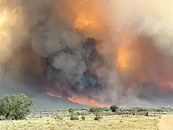 The Turner Gulch Fire on July 15, 2025. | |
| Season | |
← 2024 |
The 2025 Colorado wildfires are a series of active wildfires currently ongoing in Colorado.
Background
While "fire season" varies every year in Colorado, most wildfires occur in between May and September. However, there is an increasing fire danger in winter months. Fire conditions can be exacerbated by drought, strong winds, and vegetation growth. Climate change is leading to increased temperatures, lower humidity levels, and drought conditions are happening more often. Additionally, warmer temperatures and less precipitation can result in less snowmelt, further contributing to bad wildfire conditions.[1]
List of wildfires
The following is a list of fires that burned more than 1,000 acres (400 ha), produced significant structural damage, or resulted in casualties.
| Name | County | Acres | Start date | Containment date[a] | Notes | Ref. |
|---|---|---|---|---|---|---|
| Andrix | Baca | 1,934 | March 10 | March 10 | Cost $35,000 in suppression efforts. Burned 20 miles (32 km) east of Kim. | [3][4] |
| Meridian | El Paso | 2,540 | March 13 | March 16 | Destroyed one structure and prompted evacuations east of Colorado Springs. | [5][6] |
| Iron Ladies | Weld | 1,500 | March 17 | March 18 | 6 miles (9.7 km) west of Grover in Pawnee National Grassland. | [7][8] |
| 31 North & South | Otero | 3,400 | March 18 | March 18 | [9] | |
| US 160 | Las Animas | 2,270 | April 7 | April 7 | [10] | |
| South Rim | Montrose | 4,232 | July 10 | Lightning-caused. Burning in the Black Canyon of the Gunnison National Park. | [11] | |
| Sowbelly | Delta, Mesa, Montrose | 2274 | July 10 | August 1 | Lightning-caused. Burning in the Dominguez-Escalante National Conservation Area. | [12] |
| Turner Gulch | Mesa | 31,695 | July 10 | Lightning-caused. Burning near Gateway. | [13][14] | |
| Stoner Mesa | Montezuma County, Colorado | 7,389.6 | July 28 | Lightning-caused. | [15] | |
| Lee | Rio Blanco | 133,602.4 | August 2 | Lightning-caused. Started 18 miles southwest of Meeker.[16][17][18] | [19][20] | |
| Elk RBX | Rio Blanco | 14,518 | August 2 | August 16 | Lightning-caused. Started 10 miles east of Meeker. | [19][20] |
| Crosho | Rio Blanco, Routt | 2,200 | August 11 | Undetermined cause. | [21] |
See also
- 2025 United States wildfires
- 2025 Arizona wildfires
- 2025 Arkansas wildfires
- 2025 California wildfires
- 2025 Florida wildfires
- 2025 Idaho wildfires
- 2025 Kansas wildfires
- 2025 Louisiana wildfires
- 2025 Minnesota wildfires
- 2025 Mississippi wildfires
- 2025 Missouri wildfires
- 2025 Montana wildfires
- 2025 Nebraska wildfires
- 2025 Nevada wildfires
- 2025 New Mexico wildfires
- 2025 North Carolina wildfires
- 2025 North Dakota wildfires
- 2025 Oklahoma wildfires
- 2025 Oregon wildfires
- 2025 South Carolina wildfires
- 2025 South Dakota wildfires
- 2025 Tennessee wildfires
- 2025 Texas wildfires
- 2025 Utah wildfires
- 2025 Washington wildfires
- 2025 Wyoming wildfires
Notes
- ^ Containment means that fire crews have established and secured control lines around the fire's perimeter. These lines are artificial barriers, like trenches or cleared vegetation, designed to stop the fire's spread, or natural barriers like rivers. Containment reflects progress in managing the fire but does not necessarily mean the fire is starved of fuel, under control, or put out.[2]
References
- ^ "Colorado Fire Season: In-Depth Guide". wfca.com. Western Fire Chiefs Association. Retrieved May 25, 2025.
- ^ "What containment and other wildfire related terms mean". Los Angeles: KCAL-TV. September 12, 2024. Retrieved July 25, 2025.
- ^ "Andrix Fire Map". Watch Duty. Retrieved March 11, 2025.
- ^ "Andrix - Wildfire and Smoke Map". data.recordonline.com. Retrieved May 19, 2025.
- ^ "Meridian Fire Map". Watch Duty. Retrieved March 14, 2025.
- ^ Prentzel, Olivia (March 13, 2025). "Quickly growing Meridian fire prompts evacuations in Colorado Springs". The Colorado Sun. Retrieved May 9, 2025.
- ^ "Iron Ladies Fire Map". Watch Duty. Retrieved March 18, 2025.
- ^ "Iron Ladies - Wildfire and Smoke Map". data.oklahoman.com. The Oklahoman. Retrieved May 19, 2025.
- ^ "31 North/South Fire Map". Watch Duty. Retrieved March 18, 2025.
- ^ "US 160 Fire Map". Watch Duty. Retrieved April 7, 2025.
- ^ "South Rim Fire Map". Watch Duty. Retrieved July 13, 2025.
- ^ "Sowbelly Fire Map". Watch Duty. Retrieved July 13, 2025.
- ^ "Turner Gulch Fire Map". Watch Duty. Retrieved July 13, 2025.
- ^ "Watch Duty - Wildfire Maps & Alerts". Turner Gulch Fire Map - Watch Duty. Retrieved July 14, 2025.
- ^ "Watch Duty - Wildfire Maps & Alerts". Watch Duty. Retrieved August 14, 2025.
- ^ Krause, David. "Lee fire now 5th-largest in state history, burning more than 113k acres in northwestern Colorado". Colorado Sun. Retrieved August 11, 2025.
- ^ Krause, David. "Lee fire tops 106k acres as firefighters in northwestern Colorado start to gain containment". Colorado Sun. Retrieved August 10, 2025.
- ^ Krause, David. "Lee fire west of Meeker is so large it is creating its own weather system". Colorado Sun. Retrieved August 9, 2025.
- ^ a b "National Guard called to help firefighters battling "really, really fast" wildfires in northwestern Colorado". Colorado Sun. Retrieved August 7, 2025.
- ^ a b "Wildfire burning near Meeker destroys 3 buildings, explodes to 3,000 acres". Colorado Sun. Retrieved August 4, 2025.
- ^ "Watch Duty - Wildfire Maps & Alerts". Watch Duty. Retrieved August 14, 2025.
| Africa | South Africa (Cape Town) | ||||||
|---|---|---|---|---|---|---|---|
| Asia |
| ||||||
| Europe | |||||||
| North America |
| ||||||
| South America | |||||||
| |||||||