2025 Idaho wildfires
| 2025 Idaho wildfires | |
|---|---|
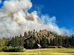 Firing operations at Taylor Ranch on the Rush Fire in July 17, 2025. | |
| Season | |
← 2024 |
The 2025 Idaho wildfires are a series of notable wildfires burning throughout the U.S. state of Idaho.
Background
While the "fire season" in Idaho varies every year based on fire weather conditions, most wildfires occur from June to September.[1] Fire activities normally increase in July and August because of drier conditions, hotter temperatures, and more lightning strikes from thunderstorms. However, wildfire severity can vary every year based on preseason conditions such as snowpack and the overcrowded growth of vegetation and dying trees.[2]
List of wildfires
The following is a list of fires that burned more than 1,000 acres (400 ha), or produced significant structural damage or casualties.
| Name | County | Acres | Start date | Containment date[a] | Notes | Ref |
|---|---|---|---|---|---|---|
| Twin Butte | Owyhee | 2,600 | May 28 | May 29 | Human-caused. Burned about 25 miles (40 km) south of Glenns Ferry. | [4][5] |
| Ashlock | Payette | 1,289 | May 29 | May 29 | Burned on Bureau of Land Management lands. Many fire agencies responded to the fire. | [6][7] |
| Dunes | Washington | 1,060 | June 3 | June 4 | Burned about 5.5 miles (8.9 km) away from Huntington, Oregon. | [8][9] |
| Garden Creek | Bingham | 5,418 | July 1 | July 3 | Cause under investigation, but likely human-caused. Evacuations issued by tribal leaders near Fort Hall. | [10][11] |
| Winter Camp | Owyhee | 2,000 | July 1 | July 1 | Unknown cause. Burned on Idaho Department of Lands area. | [12] |
| Big Bear | Idaho | 14,935 | July 9 | Lightning-caused. Burning 59 miles (95 km) northeast of McCall. | [13] | |
| Rush | Valley | 7,382 | July 10 | Lightning-caused. Burning in Frank Church–River of No Return Wilderness. | [14] | |
| Grassy | Fremont | 2,018 | July 11 | July 13 | Undetermined cause. Burned 7 miles (11 km) north of Saint Anthony. | [15] |
| Tindall | Owyhee | 1,697 | July 15 | July 16 | Undetermined cause. Burning 14 miles (23 km) southwest of Mountain Home. | [16] |
| Buckboard | Oneida | 1,698 | July 15 | Undetermined cause. Burning on BLM lands. | [17] | |
| Mm 64 I84 | Ada, Elmore | 8,902 | July 19 | July 20 | Affected Interstate 84. Evacuations were "recommended" for nearby residents. Destroyed one outbuilding. Burned 8 miles (13 km) southeast of Boise. | [18] |
| Range | Ada | 26,922 | July 31 | Evacuations were ordered in South Pleasant Valley Road and West Thompson Road. | [19] |
See also
- 2025 United States wildfires
- 2025 Arizona wildfires
- 2025 Arkansas wildfires
- 2025 California wildfires
- 2025 Colorado wildfires
- 2025 Florida wildfires
- 2025 Kansas wildfires
- 2025 Minnesota wildfires
- 2025 Mississippi wildfires
- 2025 Missouri wildfires
- 2025 Montana wildfires
- 2025 Nebraska wildfires
- 2025 Nevada wildfires
- 2025 New Mexico wildfires
- 2025 North Carolina wildfires
- 2025 North Dakota wildfires
- 2025 Oklahoma wildfires
- 2025 Oregon wildfires
- 2025 South Carolina wildfires
- 2025 South Dakota wildfires
- 2025 Tennessee wildfires
- 2025 Texas wildfires
- 2025 Utah wildfires
- 2025 Washington wildfires
- 2025 Wyoming wildfires
Notes
- ^ Containment means that fire crews have established and secured control lines around the fire's perimeter. These lines are artificial barriers, like trenches or cleared vegetation, designed to stop the fire's spread, or natural barriers like rivers. Containment reflects progress in managing the fire but does not necessarily mean the fire is starved of fuel, under control, or put out.[3]
References
- ^ "Idaho Wildfire Emissions Estimates". www2.deq.idaho.gov. Idaho Department of Environmental Quality. Retrieved April 26, 2025.
- ^ "Idaho Fire Season: In-Depth Guide". wfca.com. May 21, 2024. Retrieved April 26, 2025.
- ^ "What containment and other wildfire related terms mean". Los Angeles: KCAL-TV. September 12, 2024. Retrieved July 25, 2025.
- ^ "Twin Butte Fire Map". Watch Duty. Retrieved May 28, 2025.
- ^ "Twin Butte - Wildfire and Smoke Map". data.registerguard.com. Retrieved June 8, 2025.
- ^ "Ashlock Fire Map". Watch Duty. Retrieved June 4, 2025.
- ^ Tuttle, Zoe (May 30, 2025). "Idaho agencies work to quickly contain Ashlock Fire". KTVB. Retrieved June 8, 2025.
- ^ "Dunes Fire Map". Watch Duty. Retrieved June 4, 2025.
- ^ Christensen, Garrett (June 4, 2025). "Dunes Fire burning in Washington County Idaho near Farewell Bend 100% contained". elkhornmediagroup.com. Elkhorn Media Group. Retrieved June 8, 2025.
- ^ "Garden Creek - Wildfire and Smoke Map". data.petoskeynews.com. Retrieved July 2, 2025.
- ^ "UPDATE: Evacuations lifted for fire on Fort Hall reservation". KPVI-DT. July 1, 2025. Retrieved July 2, 2025.
- ^ "Winter Camp - Wildfire and Smoke Map". data.thegleaner.com. Retrieved July 2, 2025.
- ^ "Big Bear - Wildfire and Smoke Map". data.independentmail.com. Retrieved July 16, 2025.
- ^ "Rush Fire Information". InciWeb. Retrieved July 17, 2025.
- ^ "Grassy - Wildfire and Smoke Map". data.freep.com. Retrieved July 11, 2025.
- ^ "TINDALL - Wildfire and Smoke Map". data.usatoday.com. Retrieved July 16, 2025.
- ^ "Buckboard - Wildfire and Smoke Map". data.shelbystar.com. Retrieved July 16, 2025.
- ^ "Grass fire on I-84 between Boise and Mountain Home spreads to over 1,000 acres". KBOI-TV. July 19, 2025. Retrieved July 19, 2025.
- ^ "Range Fire Map". Watch Duty. Retrieved August 1, 2025.
| Africa | South Africa (Cape Town) | ||||||
|---|---|---|---|---|---|---|---|
| Asia |
| ||||||
| Europe | |||||||
| North America |
| ||||||
| South America | |||||||
| |||||||