Hurricane Erin (2025)
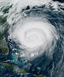
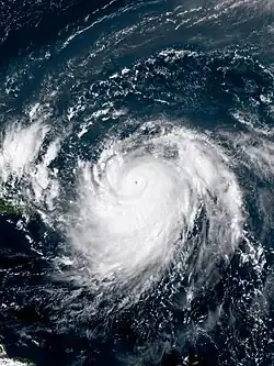 Erin at peak intensity north of the Leeward Islands on August 16 | |
| Meteorological history | |
|---|---|
| Formed | August 11, 2025 |
| Extratropical | August 22, 2025 |
| Category 5 major hurricane | |
| 1-minute sustained (SSHWS/NWS) | |
| Highest winds | 160 mph (260 km/h) |
| Lowest pressure | 915 mbar (hPa); 27.02 inHg |
| Overall effects | |
| Fatalities | 10 |
| Missing | 2 |
| Damage | Unknown |
| Areas affected | |
| IBTrACS / [1] | |
Part of the 2025 Atlantic hurricane season | |
Hurricane Erin was a powerful and sprawling August Cape Verde hurricane. The fifth named storm, first hurricane and first major hurricane[a] of the 2025 Atlantic hurricane season, Erin developed from a tropical wave on August 11, while passing westward over Cape Verde. Afterwards, Erin stayed at tropical storm status due to marginally favorable conditions as it crossed the central Atlantic the next few days. As it neared the Lesser Antilles, it strengthened into a hurricane on August 15. Very favorable conditions enabled Erin to undergo explosive intensification on August 16, reaching its peak at Category 5 intensity with one-minute maximum sustained winds of 160 mph (260 km/h) and a minimum pressure of 915 mb (27.0 inHg). An eyewall replacement cycle occurred later that day, and as a result, Erin weakened to Category 3 intensity and began growing in size. After the completion of the eyewall replacement cycle, the hurricane reintensified into a Category 4 hurricane but resumed weakening due to increasing vertical wind shear and dry air entrainment.
Erin's precursor brought intense flooding to various islands in Cape Verde, resulting in nine fatalities on São Vicente and left two people missing. Over 178 mm (7 in) of rain fell within five hours between 01:00 and 06:00 UTC on August 11. The government of Cape Verde issued a disaster declaration for São Vicente and Santo Antão the same day. Days later, Erin killed one person in the Dominican Republic. Erin later produced life-threatening surf and rip currents along much of the east coast of the United States. Its tropical-storm-force wind field while it parallelled the coast as a Category 2 hurricane extended nearly 575 mi (925 km) across, making it larger than most hurricanes of a similar intensity in the western Atlantic in this century.[3]
Meteorological history
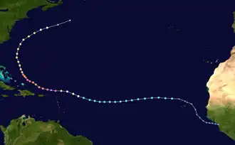
Tropical storm (39–73 mph, 63–118 km/h)
Category 1 (74–95 mph, 119–153 km/h)
Category 2 (96–110 mph, 154–177 km/h)
Category 3 (111–129 mph, 178–208 km/h)
Category 4 (130–156 mph, 209–251 km/h)
Category 5 (≥157 mph, ≥252 km/h)
Unknown
On August 8, the National Hurricane Center (NHC) first began monitoring a westward moving tropical wave just inland of the coast of West Africa, producing a large area of shower and thunderstorm activity as it approached the Atlantic Ocean.[4] As it moved out to sea and toward the Cape Verde Islands the following day, a large, well-defined low developed in association with the wave, producing disorganized convection, with sustained near gale-force winds.[5] On the morning of August 11, a small but persistent patch of deep convection developed around the now-closed center of the low, and its sustained winds increased to about 45 mph (75 km/h). Consequently, the system was designated a tropical storm by the NHC, and named Erin.[6] Erin moved quickly to the west after forming, where it encountered a poor thermodynamic environment which inhibited additional development.[7] Erin was unable to become noticeably better organized on August 12 and deep convection decreased during the morning.[8] Though the conditions around the storm continued to be only marginally conducive on August 13, the convection became more concentrated near its center, and Erin strengthened slightly that afternoon.[9] Due to persistent dry air entrainment, the storm continued to struggle the following day with establishing an inner core, and convection diminished somewhat over the low-level center late that day.[10] Nonetheless, Erin was able to strengthen into a Category 1 hurricane by 15:00 UTC on August 15.[11]
Later that day, Erin's satellite presentation improved significantly, with a small pinhole eye becoming apparent;[12] Erin subsequently underwent explosive intensification overnight and became a major hurricane early on August 16.[13] This culminated in Erin becoming a Category 5 hurricane by 15:20 UTC that day,[14] attaining its peak intensity with maximum sustained winds of 160 mph (260 km/h) and a minimum central pressure of 915 mbar (27.02 inHg), about 135 mi (220 km) north-northwest of Anguilla. At its peak, hurricane-force winds extended up to 30 mi (45 km) out from the center, and tropical-storm-force winds extend up to 160 mi (260 km) out.[15] Erin's 24-hour intensification was the greatest of any Atlantic hurricane on record based on drop in central pressure before September 1.[16] It held this intensity for much of the day, before commencing an eyewall replacement cycle; after both the Air Force Reserve and NOAA reconnaissance missions noted the presence of concentric eyewalls at Erin's core, weakening to Category 4 intensity.[17] Further weakening occurred overnight into the early morning hours of August 17 to a Category 3.[18] During the replacement cycle, the eye wall diameter increased from 6–12 mi (9–19 km) to around 45 mi (75 km). Erin also grew in size. Its hurricane-force windfield expanded to about 50 mi (85 km) from the center and the tropical storm-force winds extended outward up to 205 mi (335 km).[19] After completing the eyewall replacement cycle, Erin reintensified to Category 4 late that day,[20] and reached a secondary peak with sustained winds of 140 mph (220 km/h) and a central pressure of 933 mbar (27.55 inHg) on August 18.[21] Late that same day, however, the system weakened again to Category 3, as it tracked to the northwest, east of the Bahamas.[22] On the afternoon of August 19, Erin weakened to Category 2 strength,[23] due to strong wind shear disrupting its structure, thus permitting dry air to infiltrate into the northwestern part of the circulation.[24] However, as it moved over warm waters with abundant moisture on the morning August 20, Erin reintensified again, to a high-end Category 2 hurricane.[25]
Overnight, Erin turned toward the east-northeast. Its broad windfield was continuing to expand, with tropical storm-force winds now extending up to 300 mi (480 km) out from the center. At 06:00 UTC on August 21, it made its closest approach to the Outer Banks of North Carolina, passing about 200 mi (320 km) southeast of Cape Hatteras. It was also about 465 mi (750 km) west-northwest of Bermuda at that time.[26] Later, on the morning of August 22, the hurricane weakened to Category 1 strength due to 35–40 mph (56–65 km/h) of southwesterly wind shear, and began its transition into an extratropical cyclone,[27] as it moved northeastward over open waters midway between Bermuda and Nova Scotia.[28] Erin completed its extratropical transition that afternoon,[29] about 260 mi (418 km) south of Sable Island, Nova Scotia.[30]
Preparations
Caribbean
On August 14, a tropical storm watch was issued for Antigua and Barbuda, Saint Barthélemy, Saba, Sint Eustatius, and Saint Martin.[31] Tropical storm warnings were issued for the southern portions of the Bahamas and the Turks and Caicos Islands.[32] Tropical storm warnings were also issued for offshore Puerto Rico.[33] Saint-Martin and Martinique were also issued a yellow alert by Météo-France.[34][35] In the Dominican Republic, yellow alerts were issued for the provinces on the northern coast.[36] A flood watch was issued for Puerto Rico and the United States Virgin Islands.[37]
The National Office of Disaster Services in Antigua and Barbuda mobilized volunteer response teams.[38] Air operations were suspended in Saint Barthélemy.[39] Terrance B. Lettsome International Airport was closed in preparation for Erin.[40] Sandbagging operations were accelerated in preparation of Erin's approach in the Virgin Islands.[41] In Puerto Rico, 200 employees from the Federal Emergency Management Agency (FEMA) were deployed in preparations for possible flooding.[42] Six seaports in Puerto Rico and two in the United States Virgin Islands were closed by the United States Coast Guard.[42] In the Dominican Republic, crews cleaned out drainage infrastructure in Distrito Nacional,[43] and the beaches of María Trinidad Sánchez were closed.[44] Public services in the Turks and Caicos Islands were suspended.[45] A national systematic shutdown was issued for Grant Turk, South Caicos and Salt Cay.[46] Some ports on the island were also closed down.[47]
Liat Air cancelled flights to the British Virgin Islands and Saint Martin.[40] Caribbean Airlines cancelled flights to Tortola.[40] In Puerto Rico, more than 20 flights were cancelled.[48] Royal Caribbean's Vision of the Seas was directed to Port Canaveral, away from the Bahamas, to stay away from Erin.[49] The Disney Treasure service was rerouted to the western Caribbean.[49]
On August 16, a tropical storm watch was issued for the Turks and Caicos Islands, later upgraded to a tropical storm warning 12 hours later.[50][51] In the Bahamas, at the same time that evening on August 16, the southeastern part was placed in a tropical storm watch, later upgraded 9 hours later on the morning of August 17 to a tropical storm warning.[52] The central Bahamas later was placed under a tropical storm watch on the morning of August 18.[53]
United States
Tropical storm warnings were issued from Beaufort Inlet to Chincoteague, Virginia.[54] Dare County, North Carolina issued a state of emergency on August 17.[55] Evacuations of Zone A were also mandated for August 18 and 19 on Hatteras Island.[56] Ocracoke Island also had a state of emergency and evacuation order issued.[57] Currituck County issued evacuations for Corolla and also declared a state of emergency.[58] New Jersey, Delaware, and New York City closed their beaches.[59] The governor of North Carolina, Josh Stein, placed 200 National Guard troops and three water rescue teams on standby for Erin.[60] Crews in Tybee Island, Georgia cleared storm drains, cleared garbage, and secured signs.[61]
Rip currents created by Hurricane Erin caused hazardous swimming conditions along much of the east coast of the United States.[62] In North Carolina, Wrightsville Beach and Ocean Isle Beach officials issued no-swimming advisories through August 22, after lifeguards reported making over 50 water rescues.[63] New Jersey declared a state of emergency the same day, with Governor Phil Murphy urging people not to swim.[64]
Elsewhere
Bermuda was placed under tropical storm watch by the Bermuda Weather Service on August 19.[65] It was upgraded to a warning on August 21.[66] Ferry service to St. George's was cancelled.[67]
Crews in Nova Scotia ramped up efforts to control wildfires before Erin could change wind patterns there.[68]
Impact
Cape Verde
Heavy rainfall from Erin's precursor disturbance resulted in significant flooding across the Cape Verde islands, particularly in the northwestern island of São Vicente. After heavy rainfall inundated the island on August 11, vehicles were swept away and several homes sustained damage.[69] A total of 7.57 in (192 mm) of rain fell in just five hours on São Vicente according to the Cape Verde National Institute of Meteorology and Geophysics. Flash flooding from the sudden rain resulted in at least nine fatalities, including four children. Seven people drowned from the floods, while another person was electrocuted.[1] An additional person was reported missing while 1,500 people were displaced by the extreme rainfall and floods. Debris and fallen trees blocked off roads, while power outages affected most of the island. The Uni-Mindelo Auditorium was destroyed. Officials estimated that losses from this incident were 12,000 Cape Verdean escudos.[70] Various commercial buildings were damaged as well.[71][72][73]
In response to the significant damage and deaths, the Cape Verdean government declared a state of emergency on São Vicente and the neighboring isle of Santo Antão. The National Civil Protection Service was deployed to the islands to address infrastructure damage.[74] The service evacuated 36 and 26 people from Vila Nova and Alto Brava, respectively, on August 16.[75] The World Bank Group allocated US$10 million to support recovery efforts from the storm.[73]
Caribbean
Rough seas impacted much of the northern Leeward Islands and the Lucayan Archipelago.[76][77] In Guadeloupe, 2.48 in (63 mm) of rain was reported at Col des Mamelles, in the Guadeloupe National Park within six hours on August 16.[78] Large amounts of sargassum washed ashore on the Saint Martin and Rio San Juan in the Dominican Republic due to Erin.[79][44] Two divers were rescued off of Saint Croix.[79] Heavy rains caused roads to flood in Puerto Rico.[80] Grand Turk experienced tropical storm conditions, with roads flooding and rough seas.[81] The Bahamas was buffeted with rough seas and thunderstorms from Erin.[82] Localized flooding occurred on Mayaguana.[81] A generator was sent to Cat Island by Bahamas Power and Light.[83] Over 159,000 customers lost power in Puerto Rico.[84] On August 18, a 36-year-old man drowned at Caleta Beach in La Romana, Dominican Republic amid dangerous swimming conditions caused by Erin.[85]
United States
A station near Nags Head recorded winds of 45 mph (72 km/h) on August 21, with gusts of 54 mph (87 km/h).[86] Waves on the Outer Banks reached 20 feet (6.1 m) and the storm surge was around 2 to 4 feet (0.61 to 1.22 m).[86] Parts of North Carolina Highway 12 became flooded due to storm surges,[87][88] with the road being closed from Oregon Inlet to Hatteras.[89] Over 2,200 people were evacuated from the Outer Banks.[89] Erin caused only minimal beach erosion at Wrightsville Beach; farther north in the Outer Banks, however, waves did top sand dunes in a few areas, flooding oceanfront neighborhoods.[90] Nantucket was battered by waves and experienced decent beach erosion.[91]
Approximately 50 people were rescued from along the Jersey Shore after coastal flooding inundated roads and buildings.[92]
Northwest winds from the storm blew smoke from an Everglades National Park wildfire across Southern Florida, particularly affecting air quality in Broward County.[93]
Bermuda
Hundreds loss power on Bermuda (less than 6.5% of customers), with Pembroke Parish having the most customers out.[94] A flight from Miami and another from Connecticut were delayed due to Erin.[94]
See also
- Weather of 2025
- Tropical cyclones in 2025
- Timeline of the 2025 Atlantic hurricane season
- Other storms named Erin
- List of Category 5 Atlantic hurricanes
- List of West Africa hurricanes
- List of North Carolina hurricanes (2000–present)
Notes
- ^ Hurricanes reaching Category 3 (111 miles per hour or 179 kilometers per hour) and higher on the five-level Saffir–Simpson wind speed scale are considered major hurricanes.[2]
References
- ^ a b
Sources for the calculated death toll & missing total of Hurricane Erin:
- Joyce, Elijah (August 19, 2025). "Hurricane Erin Fatality Total: 10". 𝕏. University of Oklahoma: @WXFatalities. Archived from the original on August 22, 2025. Retrieved August 22, 2025.
- "Lusa - Business News - Cabo Verde: Government announces plan following deadly storm". LUSA. Alliance of Mediterranean News Agencies. August 16, 2025. Retrieved August 19, 2025.
- "Tempestade em São Vicente: Gabinete de Crise mantém operações de apoio às famílias afetadas" (in Portuguese). Notícias do Norte. August 19, 2025. Retrieved August 22, 2025.
- Díaz, Jazmín (August 19, 2025). "Hombre muere ahogado en playa de La Romana en medio de alertas por huracán Erin" (in Spanish). N Digital. Retrieved August 22, 2025.
- ^ "Background Information: North Atlantic Hurricane Season". College Park, Maryland: Climate Prediction Center. May 22, 2019. Archived from the original on June 22, 2021. Retrieved February 22, 2025.
- ^ Cangialosi, John (August 21, 2025). Hurricane Erin Discussion Number 42 (Report). Miami, Florida: National Hurricane Center. Retrieved August 21, 2025.
- ^ Hagen, Andrew (August 9, 2025). Seven-Day Tropical Outlook (Report). Miami, Florida: National Hurricane Center. Retrieved August 11, 2025.
- ^ Berg, Robbie; Blake, Eric (August 10, 2025). Special Tropical Weather Outlook (Report). Miami, Florida: National Hurricane Center. Retrieved August 11, 2025.
- ^ Papin, Philippe (August 11, 2025). Tropical Storm Erin Discussion Number 1 (Report). Miami, Florida: National Hurricane Center. Retrieved August 11, 2025.
- ^ Papin, Philippe (August 11, 2025). Tropical Storm Erin Discussion Number 2 (Report). Miami, Florida: National Hurricane Center. Retrieved August 11, 2025.
- ^ Pasch, Richard (August 12, 2025). Tropical Storm Erin Discussion Number 4 (Report). Miami, Florida: National Hurricane Center. Retrieved August 12, 2025.
- ^ Jack, Beven (August 13, 2025). Tropical Storm Erin Discussion Number 10 (Report). Miami, Florida: National Hurricane Center. Retrieved August 13, 2025.
- ^ Kelly, Larry (August 15, 2025). Tropical Storm Erin Discussion Number 16 (Report). Miami, Florida: National Hurricane Center. Retrieved August 15, 2025.
- ^ Jack, Beven (August 15, 2025). Hurricane Erin Discussion Number 17 (Report). Miami, Florida: National Hurricane Center. Retrieved August 15, 2025.
- ^ Papin, Philippe (August 15, 2025). Hurricane Erin Discussion Number 19 (Report). Miami, Florida: National Hurricane Center. Retrieved August 16, 2025.
- ^ Cangialosi, John; Gibbs, Alex; Kelly, Larry (August 15, 2025). Hurricane Erin Tropical Cyclone Update (Report). Miami, Florida: National Hurricane Center. Retrieved August 15, 2025.
- ^ Beven, Jack; Kelly, Larry (August 16, 2025). Hurricane Erin Tropical Cyclone Update (Report). Miami, Florida: National Hurricane Center. Retrieved August 16, 2025.
- ^ Beven, Jack (August 16, 2025). Hurricane Erin Advisory Number 22 (Report). Miami, Florida: National Hurricane Center. Retrieved August 16, 2025.
- ^ Berger, Eric (August 16, 2025). "Rapidly intensifying Hurricane Erin becomes historic storm due to strengthening". Ars Technica. Retrieved August 16, 2025.
- ^ Papin, Philippe (August 16, 2025). Hurricane Erin Discussion Number 23 (Report). Miami, Florida: National Hurricane Center. Retrieved August 17, 2025.
- ^ Cangialosi, John (August 17, 2025). Hurricane Erin Discussion Number 24 (Report). Miami, Florida: National Hurricane Center. Retrieved August 17, 2025.
- ^ Pasch, Richard (August 17, 2025). Hurricane Erin Discussion Number 26 (Report). Miami, Florida: National Hurricane Center. Retrieved August 17, 2025.
- ^ Papin, Philippe (August 17, 2025). "Hurricane Erin Discussion Number 27". Miami, Florida: National Hurricane Center. Retrieved August 18, 2025.
- ^ Pasch, Richard (August 18, 2025). Hurricane Erin Discussion Number 29 (Report). Miami, Florida: National Hurricane Center. Retrieved August 20, 2025.
- ^ Beven, Jack (August 18, 2025). Hurricane Erin Advisory Number 31 (Report). Miami, Florida: National Hurricane Center. Retrieved August 19, 2025.
- ^ Pasch, Richard (August 19, 2025). Hurricane Erin Intermediate Advisory Number 33A (Report). Miami, Florida: National Hurricane Center. Retrieved August 19, 2025.
- ^ Berg, Robbie (August 19, 2025). Hurricane Erin Advisory Number 32 (Report). Miami, Florida: National Hurricane Center. Retrieved August 19, 2025.
- ^ Pasch, Richard (August 20, 2025). Hurricane Erin Discussion Number 37 (Report). Miami, Florida: National Hurricane Center. Retrieved August 20, 2025.
- ^ Berg, Robbie; Hagen, Andrew (August 21, 2025). Hurricane Erin Intermediate Advisory Number 39A (Report). Miami, Florida: National Hurricane Center. Retrieved August 21, 2025.
- ^ Berg, Robbie (August 22, 2025). Hurricane Erin Discussion Number 44 (Report). Miami, Florida: National Hurricane Center. Retrieved August 22, 2025.
- ^ Berg, Robbie (August 22, 2025). Hurricane Erin Advisory Number 44 (Report). Miami, Florida: National Hurricane Center. Retrieved August 22, 2025.
- ^ Blake, Eric (August 22, 2025). Post-Tropical Cyclone Erin Discussion Number 46 (Report). Miami, Florida: National Hurricane Center. Retrieved August 22, 2025.
- ^ Tropical Cyclone Information Statement (Erin) (Report). Dartmouth, Nova Scotia: Canadian Hurricane Centre. August 22, 2025. Archived from the original on August 22, 2025. Retrieved August 22, 2025.
- ^ "Tropical Storm Erin to gradually strengthen. See its forecast track and intensity". NBC 6 South Florida. August 14, 2025. Retrieved August 14, 2025.
- ^ Pasch, Richard (August 17, 2025). "Hurricane Erin Intermediate Advisory Number 25A". National Hurricane Center. Miami, Florida. Retrieved August 17, 2025.
- ^ Alsharif, Mirna (August 16, 2025). "Hurricane Erin rapidly strengthens to Category 5 storm near the Caribbean". NBC News. Retrieved August 16, 2025.
- ^ Charoy, Paul (August 15, 2025). "Ouragan Erin : Saint-Martin en vigilance jaune pour fortes pluies, orages, vagues-submersion et vents violents" [Hurricane Erin: Saint Martin is in a yellow alert for strong rains, storms, waves, and violent winds.]. Journal Le Pélican à Saint-Martin (in French). Retrieved August 15, 2025.
- ^ "Erin se renforce brusquement et passe en «ouragan catastrophique» de catégorie 5". France-Antilles (in French). August 16, 2025. Retrieved August 16, 2025.
- ^ Alcántara, Lency (August 16, 2025). "COE eleva alerta por huracán Erin: oleaje peligroso y lluvias intensas en la costa norte". Hoy Digital (in Spanish). Retrieved August 17, 2025.
- ^ US Department of Commerce, NOAA. "San Juan, PR". Weather.gov. Retrieved August 17, 2025.
- ^ "Tropical storm watch issued for some northern parts of the Leeward Islands". Jamaica Gleaner. Bridgetown, Barbados. August 14, 2025. Retrieved August 15, 2025.
- ^ "L'ouragan Erin atteint une intensité de catégorie 5" [Hurricane Erin has attained an intensity of Category 5]. Le Journal de Saint-Barth (in French). August 16, 2025. Retrieved August 16, 2025.
- ^ a b c "Hurricane Erin advances to Cat 4 status triggering mass flight cancellations, airport shutdowns". WIC News. August 16, 2025. Retrieved August 16, 2025.
- ^ Yablonski, Steven (August 14, 2025). "Tropical Storm Erin prompts alerts in Caribbean as it inches closer to becoming hurricane". FOX Weather. Retrieved August 14, 2025.
- ^ a b "Erin becomes a Category 4 hurricane in Caribbean and is expected to get stronger before swerving from continental U.S." CBS News. August 16, 2025. Retrieved August 16, 2025.
- ^ "Huracán Erin: Acciones de prevención en el Distrito Nacional ante posibles afectaciones". Hoy Digital (in Spanish). August 16, 2025. Retrieved August 16, 2025.
- ^ a b "Clausuran playas en el norte por huracán Erin". Cadena de Noticias (in Spanish). August 17, 2025. Retrieved August 18, 2025.
- ^ Lenthang, Marlene (August 18, 2025). "Hurricane Erin forecasted to bring life-threatening surf and rip currents as Category 4". NBC News. Retrieved August 18, 2025.
- ^ "Hurricane Erin forecast to bring life-threatening surf and rip currents as Category 4". NBC News. August 18, 2025. Retrieved August 19, 2025.
- ^ Finley, Ben; Seewer, John (August 18, 2025). "Hurricane Erin forces evacuations on North Carolina's Outer Banks but expected to stay offshore". AP News. Retrieved August 18, 2025.
- ^ Rivera, Ivelisse (August 17, 2025). "Hurricane Erin weakens to Category 3 as forecasters wait for northward turn". AP News. San Juan, Puerto Rico. Retrieved August 17, 2025.
- ^ a b "Florida Today Subscription Offers, Specials, and Discounts". Florida Today. Retrieved August 18, 2025.
- ^ Beven (August 16, 2025). "Hurricane Erin Public Advisory 24". Miami, Florida: National Hurricane Center. Retrieved August 19, 2025.
- ^ Cangialosi (August 16, 2025). "Hurricane Erin Public Advisory 24". Miami, Florida: National Hurricane Center. Retrieved August 19, 2025.
- ^ Pasch (August 17, 2025). "Hurricane Erin Public Advisory 25A". Miami, Florida: National Hurricane Center. Retrieved August 19, 2025.
- ^ Cangialosi (August 18, 2025). "Hurricane Erin Public Advisory 28". Miami, Florida: National Hurricane Center. Retrieved August 19, 2025.
- ^ Pasch (August 20, 2025). "Hurricane Erin Public Advisory 37". Miami, Florida: National Hurricane Center. Retrieved August 20, 2025.
- ^ Eldridge, John (August 17, 2025). "Dare County issues State of Emergency ahead of Hurricane Erin". WAVY-TV. Retrieved August 17, 2025.
- ^ Cooper, Tracy (August 17, 2025). "Dare County orders Hatteras Island evacuation as Hurricane Erin nears". WVEC-TV. Retrieved August 17, 2025.
- ^ Yablonski, Steven (August 18, 2025). "Hurricane Erin's life-threatening impacts prompt North Carolina evacuations, states of emergency". FOX Weather. Retrieved August 18, 2025.
- ^ Yablonski, Steven (August 20, 2025). "Hurricane Erin begins producing massive waves, dangerous rip currents along East Coast beaches". FOX Weather. Retrieved August 20, 2025.
- ^ Robinson, Taylor; Ives, Mike (August 19, 2025). "Hurricane Erin Brings Rip Currents Closing NYC and NJ Beaches". New York Times. Retrieved August 19, 2025.
- ^ Yablonski, Steven (August 20, 2025). "Hurricane Erin begins producing massive waves, dangerous rip currents along East Coast beaches". FOX Weather. Retrieved August 20, 2025.
- ^ Lupiani, Joyce (August 20, 2025). "Tybee Island, coastal Georgia getting ready for Hurricane Erin impacts". FOX 5 Atlanta. Retrieved August 21, 2025.
- ^ Pulver, Dinah Voyles; Bacon, John (August 19, 2025). "Hurricane Erin starts rough slog up US East Coast: Live updates". USA Today. Retrieved August 19, 2025.
- ^ McGrath, Gareth (August 19, 2025). "Wrightsville Beach, Ocean Isle issue no swimming advisories as Hurricane Erin approaches". Star-News. Retrieved August 19, 2025.
- ^ Fan, Christina; Gussoff, Carolyn; Sloan, Christine; Duddridge, Natalie (August 21, 2025). "Gov. Murphy declares state of emergency in N.J. as high surf from Hurricane Erin combines with high tide". CBS News. Retrieved August 21, 2025.
- ^ Pasch, Richard (August 19, 2025). "Hurricane Erin Advisory Number 34". National Hurricane Center. Miami, Florida. Retrieved August 19, 2025.
- ^ Cangialosi, John (August 21, 2025). "Hurricane Erin Intermediate Advisory Number 41A". National Hurricane Center. Miami, Florida. Retrieved August 21, 2025.
- ^ Hendrickson, Sékou (August 19, 2025). "Jaché Adams: stay vigilant as Hurricane Erin draws closer". The Royal Gazette. Retrieved August 19, 2025.
- ^ Patil, Anjuli (August 21, 2025). "How long will it take to control the N.S. wildfire? Hurricane Erin makes it hard to predict". Canadian Broadcasting Corporation. Retrieved August 22, 2025.
- ^ "São Vicente/Chuvas: Número de mortos sobe para sete – ministro" [São Vicente/Chuvas: Death toll rises to seven - minister] (in Portuguese). DTudo1Pouco. August 11, 2025. Retrieved August 12, 2025.
- ^ "São Vicente: Auditório da Uni-Mindelo destruído pelas cheias, com prejuízo de 12 mil contos". Balai (in European Portuguese). August 12, 2025. Retrieved August 19, 2025.
- ^ Jenn Jordan (August 12, 2025). "Tropical Storm Erin Kills 7 In Cabo Verde Islands As It Tracks Across Atlantic". The Weather Channel. Retrieved August 12, 2025.
- ^ Teo Blašković (August 12, 2025). "Nine killed as Tropical Storm Erin floods São Vicente, Cape Verde". The Watchers. Retrieved August 12, 2025.
- ^ a b dos Santos, Eduino (August 13, 2025). "Cabo Verde/chuvas: Banco Mundial disponibiliza 10 milhões de dólares para resposta à tempestade tropical". Notícias do Norte (in European Portuguese). Retrieved August 16, 2025.
- ^ Sheilla Ribeiro (August 11, 2025). "Governo declara Estado de calamidade em São Vicente e Santo Antão" [Government declares State of Calamity in São Vicente and Santo Antão]. Expresso das Ilhas (in Portuguese). Retrieved August 12, 2025.
- ^ "Proteção Civil evacua cerca de 60 pessoas em Vila Nova e Alto Brava". Expresso das Ilhas (in Portuguese). August 17, 2025. Retrieved August 17, 2025.
- ^ "Erin downgraded to Category 3 hurricane, NHC says". Al Jazeera. August 17, 2025. Retrieved August 17, 2025.
- ^ "Hurricane Erin strengthens to category four, southeast Bahamas feels impact". Eye Witness News. August 19, 2025. Retrieved August 19, 2025.
- ^ "Erin est un ouragan de catégorie 4, la vigilance jaune fortes pluies et orages maintenue dans l'archipel". France-Antilles (in French). August 16, 2025. Retrieved August 16, 2025.
- ^ a b Alsharif, Mirna; Rapp, Christine; Noriega, Tangni (August 17, 2025). "Thousands without power in Puerto Rico as Hurricane Erin pummels region". NBC News. Retrieved August 17, 2025.
- ^ Chappell, Bill; Kim, Juliana (August 18, 2025). "Hurricane Erin: Storm surge watch is issued for North Carolina's Outer Banks". NPR. Retrieved August 19, 2025.
- ^ a b Williams, Joshua (August 18, 2025). "Southeastern Bahamas And TCI Experience Tropical Storm Conditions". Our News. Retrieved August 20, 2025.
- ^ "All clear issued for Bahamas and Turks & Caicos as Hurricane Erin moves north". Eye Witness News. August 19, 2025. Retrieved August 20, 2025.
- ^ McDermott, Berthony (August 19, 2025). "DRM Update: Southern Islands Fare Well As Erin Moves North". Our News. Retrieved August 20, 2025.
- ^ "Hurricane Erin downgraded to Category 3 storm". NPR. August 17, 2025. Retrieved August 17, 2025.
- ^ Díaz, Jazmín (August 19, 2025). "Hombre muere ahogado en playa de La Romana en medio de alertas por huracán Erin" (in Spanish). N Digital. Retrieved August 22, 2025.
- ^ a b Sistek, Scott (August 20, 2025). "Hurricane Erin slams North Carolina, Virginia coasts with strong winds, powerful waves, dangerous rip currents". FOX Weather. Retrieved August 21, 2025.
- ^ Hernandez, Joe (August 20, 2025). "Flooding begins in the Outer Banks as Hurricane Erin moves north". NPR. Retrieved August 20, 2025.
- ^ Melton, Brittney (August 21, 2025). "Israel will call up 60,000 reservists. And, N.C. braces for effects of Hurricane Erin". NPR. Retrieved August 21, 2025.
- ^ a b Geoghegan, Tom (August 21, 2025). "Hurricane Erin's high waves thrash coast of North Carolina". BBC. Retrieved August 21, 2025.
- ^ Kirk, Heidi (August 21, 2025). "Hurricane Erin aftermath: Erosion at Wrightsville Beach, dangerous rip current risk". WRAL-TV. Retrieved August 21, 2025.
- ^ Tran, Jericho (August 21, 2025). "Nantucket expecting hazardous wind gusts and surf from Hurricane Erin". NBC Boston. Retrieved August 22, 2025.
- ^ Reiman, Kyle; Haworth, Jon; Shapiro, Emily; Deliso, Meredith; Forrester, Megan (August 22, 2025). "Around 50 people rescued from flooding along Jersey Shore". ABC News. Retrieved August 22, 2025.
- ^ Trujillo, Briana; Berg, Adam (August 21, 2025). "Wildfire burns 42,000 acres in the Everglades as smoke blankets South Florida". WTVJ. Retrieved August 21, 2025.
- ^ a b Hendrickson, Sékou (August 22, 2025). "Hundreds lose power as Erin leaves island relatively unscathed". Retrieved August 22, 2025.
External Links
- The National Hurricane Center's Hurricane Erin advisory archive
| 1920s |
|
|---|---|
| 1930s |
|
| 1940s |
|
| 1950s | |
| 1960s | |
| 1970s | |
| 1980s | |
| 1990s | |
| 2000s | |
| 2010s | |
| 2020s | |
| |
Tropical cyclones of the 2025 Atlantic hurricane season | |
|---|---|
|