Timeline of the 2025 Atlantic hurricane season
| Timeline of the 2025 Atlantic hurricane season | |||||
|---|---|---|---|---|---|
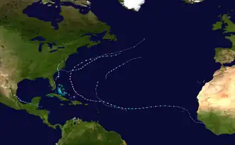 Season summary map | |||||
| Season boundaries | |||||
| First system formed | June 24, 2025 | ||||
| Last system dissipated | Season ongoing | ||||
| Strongest system | |||||
| Name | Erin | ||||
| Maximum winds | 160 mph (260 km/h) (1-minute sustained) | ||||
| Lowest pressure | 915 mbar (hPa; 27.02 inHg) | ||||
| Longest lasting system | |||||
| Name | Erin | ||||
| Duration | 8 days | ||||
| |||||
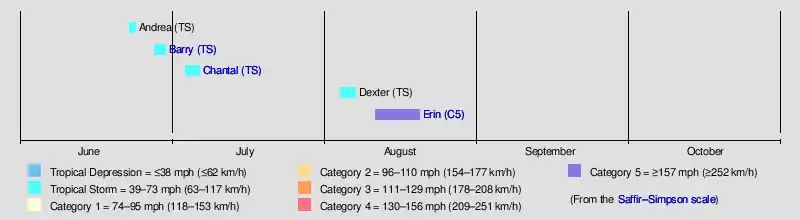
The 2025 Atlantic hurricane season is the current cycle of the annual tropical cyclone season in the Atlantic Ocean in the Northern Hemisphere. The season officially began on June 1, and will end on November 30. These dates, adopted by convention, historically describe the period in each year when most subtropical or tropical cyclogenesis occurs in the Atlantic Ocean (over 97%).[1] No subtropical or tropical development occurred in the Atlantic prior to the start of the season, and the season got off to the slowest start since 2014. Even so, hurricane researchers are predicting an above-normal number of named storms this year.[nb 1][3]
This timeline documents tropical cyclone formations, strengthening, weakening, landfalls, extratropical transitions, and dissipations during the season. It includes information that was not released throughout the season, meaning that data from post-storm reviews by the National Hurricane Center, such as a storm that was not initially warned upon, has been included.
By convention, meteorologists use one time zone when issuing forecasts and making observations: Coordinated Universal Time (UTC), and also use the 24-hour clock (where 00:00 = midnight UTC).[4] The National Hurricane Center uses both UTC and the time zone where the center of the tropical cyclone is currently located. The time zones utilized (east to west) are: Greenwich, Cape Verde, Atlantic, Eastern, and Central.[5] In this timeline, all information is listed by UTC first, with the respective regional time zone included in parentheses. Additionally, figures for maximum sustained winds and position estimates are rounded to the nearest 5 units (knots, miles, or kilometers), following National Hurricane Center practice. Direct wind observations are rounded to the nearest whole number. Atmospheric pressures are listed to the nearest millibar and nearest hundredth of an inch of mercury.
Timeline of events
June
June 1
- The 2025 Atlantic hurricane season officially begins.[1]
June 23
- 06:00 UTC (2:00 a.m. AST) at 32°36′N 56°18′W / 32.6°N 56.3°W – A tropical depression forms from a low-pressure area about 490 mi (785 km) east of Bermuda.[6]
- 12:00 UTC (8:00 a.m. AST) at 33°12′N 55°12′W / 33.2°N 55.2°W – The tropical depression strengthens into Tropical Storm Andrea about 560 mi (900 km) east of Bermuda. It simultaneously reaches its peak intensity, with maximum sustained winds of 40 mph (65 km/h) and a minimum central pressure of 1014 mbar (29.94 inHg).[6]
June 24
- 18:00 UTC (2:00 p.m. AST) at 37°18′N 48°12′W / 37.3°N 48.2°W – Tropical Storm Andrea transitions into a post-tropical cyclone about 995 mi (1,600 km) east-northeast of Bermuda, and later dissipates.[6]
June 28
- 21:00 UTC (4:00 p.m. CDT) at 19°18′N 94°12′W / 19.3°N 94.2°W – Tropical Depression Two forms about 240 km (385 km) east-southeast of Tuxpan, Veracruz.[7]
June 29
- 15:00 UTC (10:00 a.m. CDT) at 20°24′N 96°12′W / 20.4°N 96.2°W – Tropical Depression Two strengthens into Tropical Storm Barry about 90 mi (140 km) east-southeast of Tuxpan.[8]
- 18:00 UTC (1:00 p.m. CDT) at 20°48′N 96°36′W / 20.8°N 96.6°W – Tropical Storm Barry reaches peak intensity with maximum sustained winds of 45 mph (75 km/h) and a minimum central pressure of 1006 mbar (29.71 inHg), about 50 mi (80 km) east-southeast of Tuxpan.[9]
June 30
- 03:00 UTC (10:00 p.m. CDT, June 29) at 22°00′N 97°48′W / 22.0°N 97.8°W – Tropical Storm Barry weakens to a tropical depression and simultaneously makes landfall on the eastern coast of Mexico with sustained winds of 35 mph (55 km/h), about 15 mi (25 km) south-southeast of Tampico, Tamaulipas.[10]
- 09:00 UTC (4:00 a.m. CDT) at 23°00′N 99°12′W / 23.0°N 99.2°W – Tropical Depression Barry dissipates inland, about 100 mi (160 km) northwest of Tampico.[11]
July
July 4
- 21:00 UTC (5:00 p.m. EDT) at 30°48′N 79°00′W / 30.8°N 79.0°W – Tropical Depression Three forms about 150 mi (240 km) south-southeast of Charleston, South Carolina.[12]
July 5
- 12:00 UTC (8:00 a.m. EDT) at 30°54′N 79°00′W / 30.9°N 79.0°W – Tropical Depression Three strengthens into Tropical Storm Chantal about 150 mi (240 km) south-southeast of Charleston.[13]
July 6
- 06:00 UTC (2:00 a.m. EDT) at 33°12′N 78°48′W / 33.2°N 78.8°W – Tropical Storm Chantal reaches peak intensity with maximum sustained winds of 60 mph (95 km/h) and a minimum central pressure of 1002 mbar (29.59 inHg), about 75 mi (115 km) east-northeast of Charleston.[14]
- 09:00 UTC (5:00 a.m. EDT) at 33°36′N 79°06′W / 33.6°N 79.1°W – Tropical Storm Chantal makes landfall in far eastern South Carolina with sustained winds of 50 mph (85 km/h), about 70 mi (115 km) northeast of Charleston.[15]
- 15:00 UTC (11:00 a.m. EDT) at 34°24′N 79°12′W / 34.4°N 79.2°W – Tropical Storm Chantal weakens to a tropical depression inland, about 20 mi (30 km) southwest of Lumberton, North Carolina.[16]
July 7
- 15:00 UTC (11:00 a.m. EDT) at 37°30′N 76°18′W / 37.5°N 76.3°W – Tropical Depression Chantal transitions to a post-tropical cyclone inland, about 30 mi (50 km) north-northeast of Newport News, Virginia.[17]
August
August 4
- 03:00 UTC (11:00 p.m. AST, August 3) at 34°18′N 69°24′W / 34.3°N 69.4°W – Tropical Storm Dexter forms about 300 mi (480 km) west-northwest of Bermuda.[18]
August 7
- 09:00 UTC (5:00 a.m. AST) at 40°36′N 52°06′W / 40.6°N 52.1°W – Tropical Storm Dexter reaches its peak intensity, with maximum sustained winds of 50 mph (85 km/h) and a minimum central pressure of 998 mbar (29.47 inHg), about 425 mi (685 km) south of Cape Race, Newfoundland.[19]
- 15:00 UTC (11:00 a.m. AST) at 41°24′N 50°24′W / 41.4°N 50.4°W – Tropical Storm Dexter transitions into an extratropical cyclone about 390 mi (625 km) south-southeast of Cape Race.[20]
August 11
- 15:00 UTC (2:00 p.m. CVT) at 17°24′N 28°00′W / 17.4°N 28.0°W – Tropical Storm Erin forms about 280 mi (455 km) west-northwest of the Cape Verde islands.[21]
August 15
- 15:00 UTC (11:00 a.m. AST) at 18°12′N 56°06′W / 18.2°N 56.1°W – Tropical Storm Erin strengthens into a Category 1 hurricane about 460 mi (740 km) east of the northern Leeward Islands, making it the first hurricane of the season.[22]
August 16
- 03:00 UTC (11:00 p.m. AST, August 15) at 19°30′N 59°30′W / 19.5°N 59.5°W – Hurricane Erin strengthens to Category 2 intensity about 250 mi (405 km) east-northeast of Anguilla.[23]
- 09:00 UTC (5:00 a.m. AST) at 19°48′N 61°06′W / 19.8°N 61.1°W – Hurricane Erin strengthens to Category 3 intensity about 170 mi (275 km) northeast of Anguilla, making it the first major hurricane of the season.[24]
- 09:50 UTC (5:50 a.m. AST) at 19°36′N 61°30′W / 19.6°N 61.5°W – Hurricane Erin strengthens to Category 4 intensity about 150 mi (240 km) northeast of Anguilla.[25]
- 15:20 UTC (11:20 a.m. AST) at 19°42′N 62°48′W / 19.7°N 62.8°W – Hurricane Erin strengthens to Category 5 intensity about 105 mi (170 km) north of Anguilla.[26]
August 17
- 00:00 UTC (8:00 p.m. AST, August 16) at 20°00′N 64°36′W / 20.0°N 64.6°W – Hurricane Erin weakens to Category 4 intensity about 150 mi (235 km) northeast of San Juan, Puerto Rico.[27]
- 06:00 UTC (2:00 a.m. AST) at 20°24′N 66°06′W / 20.4°N 66.1°W – Hurricane Erin weakens to Category 3 intensity about 140 mi (220 km) north of San Juan.[28]
August 18
- 03:00 UTC (11:00 p.m. AST, August 17) at 22°18′N 69°18′W / 22.3°N 69.3°W – Hurricane Erin regains Category 4 intensity about 130 mi (205 km) east-northeast of Grand Turk Island.[29]
November
November 30
- The 2025 Atlantic hurricane season officially ends.[1]
See also
- Timeline of the 2025 Pacific hurricane season
- Tropical cyclones in 2025
- Lists of Atlantic hurricanes
Notes
- ^ An average Atlantic hurricane season, as defined by the National Oceanic and Atmospheric Administration, has fourteen tropical storms, seven hurricanes and three major hurricanes.[2]
References
- ^ a b c "Hurricanes Frequently Asked Questions". Miami, Florida: NOAA Atlantic Oceanographic and Meteorological Laboratory. June 1, 2021. Retrieved June 24, 2025.
- ^ "Background Information: North Atlantic Hurricane Season". College Park, Maryland: NOAA Climate Prediction Center. Retrieved June 24, 2025.
- ^ Lea, Adam (May 23, 2025). "Pre-Season Forecast Update for North Atlantic Hurricane Activity in 2025" (PDF). Tropical Storm Risk. London, United Kingdom: EuroTempest Ltd. Retrieved June 24, 2025.
- ^ "Understanding the Date/Time Stamps". Miami, Florida: NOAA National Hurricane Center. Retrieved June 24, 2025.
- ^ "Update on National Hurricane Center Products and Services for 2020" (PDF). Miami, Florida: National Hurricane Center. April 20, 2020. Retrieved June 24, 2025.
- ^ a b c Cangialosi, John P. (August 12, 2025). Tropical Storm Andrea (AL012025) (PDF) (Report). Miami, Florida: National Hurricane Center. Archived (PDF) from the original on August 16, 2025. Retrieved August 16, 2025.
- ^ Papin, Philippe (June 28, 2025). Tropical Depression Two Advisory Number 1 (Report). Miami, Florida: National Hurricane Center. Retrieved June 28, 2025.
- ^ Papin, Philippe (June 29, 2025). Tropical Storm Barry Advisory Number 4 (Report). Miami, Florida: National Hurricane Center. Retrieved June 29, 2025.
- ^ Papin, Philippe (June 29, 2025). Tropical Storm Barry Intermediate Advisory Number 4A (Report). Miami, Florida: National Hurricane Center. Retrieved June 30, 2025.
- ^ Pasch, Richard (June 30, 2025). Tropical Depression Barry Advisory Number 6 (Report). Miami, Florida: National Hurricane Center. Retrieved June 30, 2025.
- ^ Cangialosi, John (June 30, 2025). Remnants of Barry Advisory Number 7 (Report). Miami, Florida: National Hurricane Center. Retrieved June 30, 2025.
- ^ Beven, Jack (July 4, 2025). Tropical Depression Three Advisory Number 1 (Report). Miami, Florida: National Hurricane Center. Retrieved July 4, 2025.
- ^ Cangialosi, John; Konarik, Stephen (July 5, 2025). Tropical Storm Chantal Intermediate Advisory Number 3A (Report). Miami, Florida: National Hurricane Center. Retrieved July 5, 2025.
- ^ Papin, Philippe (July 6, 2025). Tropical Storm Chantal Intermediate Advisory Number 6A (Report). Miami, Florida: National Hurricane Center. Retrieved July 6, 2025.
- ^ Papin, Philippe (July 6, 2025). Tropical Storm Chantal Advisory Number 7 (Report). Miami, Florida: National Hurricane Center. Retrieved July 6, 2025.
- ^ Brown, Daniel (July 6, 2025). Tropical Depression Chantal Advisory Number 8 (Report). Miami, Florida: National Hurricane Center. Retrieved July 6, 2025.
- ^ Santorelli, Allison; Taylor, Zack; Shieh, Owen (July 7, 2025). Post-Tropical Cyclone Chantal Advisory Number 12 (Report). College Park, Maryland: Weather Prediction Center. Retrieved July 7, 2025.
- ^ Berg, Robbie (August 4, 2025). Tropical Storm Dexter Advisory Number 1 (Report). Miami, Florida: National Hurricane Center. Retrieved August 4, 2025.
- ^ Beven, Jack (August 7, 2025). Tropical Storm Dexter Advisory Number 11 (Report). Miami, Florida: National Hurricane Center. Retrieved August 16, 2025.
- ^ Hagen, Andrew (August 7, 2025). Post-Tropical Cyclone Dexter Advisory Number 15 (Report). Miami, Florida: National Hurricane Center. Retrieved August 16, 2025.
- ^ Papin, Philippe (August 11, 2025). Tropical Storm Erin Advisory Number 1 (Report). Miami, Florida: National Hurricane Center. Retrieved August 16, 2025.
- ^ Beven, Jack (August 15, 2025). Hurricane Erin Advisory Number 17 (Report). Miami, Florida: National Hurricane Center. Retrieved August 16, 2025.
- ^ Papin, Philippe (August 15, 2025). Hurricane Erin Advisory Number 19 (Report). Miami, Florida: National Hurricane Center. Retrieved August 16, 2025.
- ^ Cangialosi, John (August 16, 2025). Hurricane Erin Advisory Number 20 (Report). Miami, Florida: National Hurricane Center. Retrieved August 16, 2025.
- ^ Cangialosi, John; Gibbs, Andy; Kelly, Larry (August 16, 2025). Hurricane Erin Tropical Cyclone Update (Report). Miami, Florida: National Hurricane Center. Retrieved August 17, 2025.
- ^ Beven, Jack; Kelly, Larry (August 16, 2025). Hurricane Erin Tropical Cyclone Update (Report). Miami, Florida: National Hurricane Center. Retrieved August 17, 2025.
- ^ Papin, Philippe (August 16, 2025). Hurricane Erin Intermediate Advisory Number 22A (Report). Miami, Florida: National Hurricane Center. Retrieved August 17, 2025.
- ^ Cangialosi, John (August 17, 2025). Hurricane Erin Intermediate Advisory Number 23A (Report). Miami, Florida: National Hurricane Center. Retrieved August 17, 2025.
- ^ Papin, Philippe (August 17, 2025). "Hurricane Erin Advisory Number 27". National Hurricane Center. Retrieved August 18, 2025.