Tochigi–Gunma–Saitama border
Sankenkyō (三県境) | |
 The monument on the tripoint | |
| Coordinates | 36°12′27″N 139°39′50″E / 36.20750°N 139.66389°E |
|---|---|
| Opening date | March 31, 2016 |
The Tochigi–Gunma–Saitama border or the Tochigi–Gunma–Saitama tripoint (Japanese: 栃木・群馬・埼玉の三県境, Hepburn: Tochigi-Gunma-Saitama no Sankenkyō) or simply Sankenkyō (三県境; lit. "Three borders")[1][2] is a tripoint between Tochigi Prefecture, Gunma Prefecture, and Saitama Prefecture in Japan. It is considered rare as it is a tripoint in Japan that is not located on a mountain or a river.
Geography
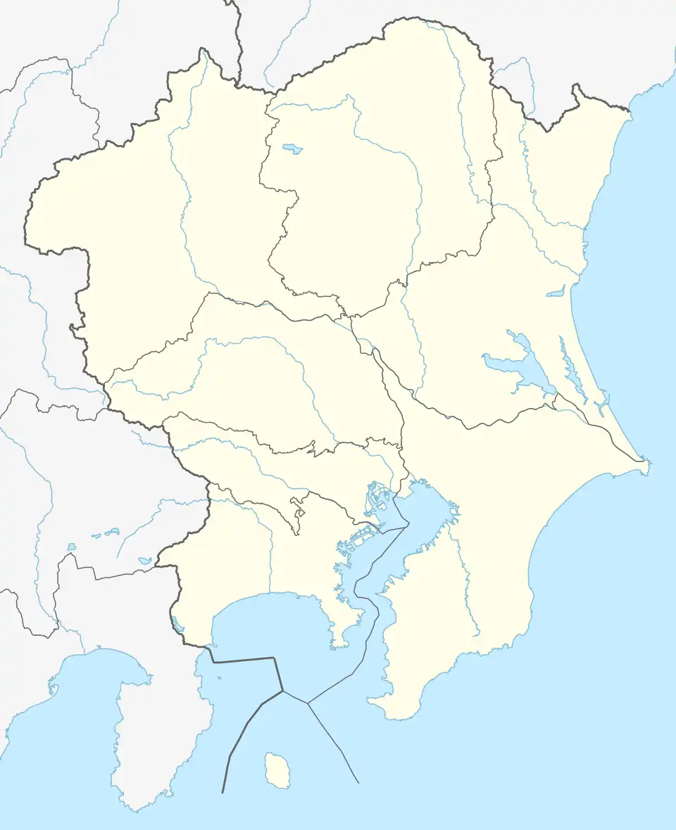
The border is located southwest of the Watarase Reservoir, also known as Lake Yanaka. It is where the town of Itakura, Gunma, and the cities of Tochigi, Tochigi, and Kazo, Saitama meet.[3] It is located about 5.4 kilometres (3.4 mi) east of Ikura, Gunma's town hall and about 400 metres (1,300 ft) east of Yagyu Station in Kazu, Saitama.[4][5] Due to it being on flatland, it is considered rare as a "walkable" tripoint in Japan, as the other 40 tripoints are located on mountains or rivers.[6][4]
History
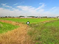
Originally, the tripoint between Tochigi, Gunma, and Saitama was located on the Watarase River. The course was changed after the Ashio Copper Mine incident in the Meiji Era, which turned the area into a swamp and was later filled in with 2 metres (6.6 ft) of soil in the 1970s. It was later used as rice paddies, which were owned by Mitsuaki Furusawa—a resident from the Tochigi side, and a Y-shaped irrigation canal became the border.[3][7][8]
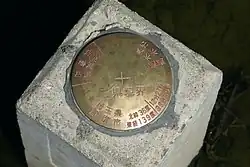
Joint discussions were conducted between the government of Itakura, Gunma, Tochigi City, Tochigi, and Kazo, Saitama, along with the Geospatial Information Authority of Japan from January 2015. A joint survey was conducted on February 9, 2016, confirming the tripoint was located at 36°12′27″N 139°39′50″E / 36.20750°N 139.66389°E, the survey costed ¥1.3 million (2016) (US$11,949.31), which is split between the three cities and towns.[8][9] A signing ceremony was conducted on March 31, 2016 between the three mayors of the towns and cities and Furusawa. A concrete pole with a 8 centimetres (3.1 in) brass plaque was erected at the border with the words "San Kenkyōkai" (三県境界, "Three Perfectural Borders").[9][10]
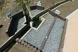
A stamp rally was held in the area from February to March 2017.[11] Due to the growing number of tourists visiting the area, the three towns and cities bought the land and constructed a promenade, which was finished in April 2018.[12]
See also
References
- ^ "歩いて行ける「三県境」 - 板倉町". www.town.itakura.gunma.jp. Retrieved July 27, 2025.
- ^ "三県境|加須市". www.city.kazo.lg.jp (in Japanese). Retrieved July 27, 2025.
- ^ a b "3県境:群馬、栃木、埼玉…境界線確認、新観光スポットに". Mainichi Shimbun (in Japanese). February 9, 2016. Retrieved July 27, 2025.
- ^ a b "またげる3県境 栃木・群馬・埼玉で観光地計画". The Asahi Shimbun. January 14, 2016. Archived from the original on March 26, 2016. Retrieved July 27, 2025.
- ^ "あいまい「平地の3県境」確定へ 群馬、栃木、埼玉". Jōmō Shimbun. February 10, 2016. Archived from the original on February 10, 2016. Retrieved August 2, 2025.
- ^ "愛媛県~広島県の"隠れ県境"がまさかの日本最短!? 最長県境も愛媛県!? 意外と知らない県境の"魅力"と"可能性" | 愛媛のニュース - Nスタえひめ|あいテレビは6チャンネル (6ページ)". TBS News (in Japanese). February 17, 2025. Retrieved July 27, 2025.
- ^ "不明の境界点ここだった! 平地の3県境で測量調査". The Tokyo Shimbun. February 10, 2016. Archived from the original on September 13, 2016. Retrieved July 27, 2025.
- ^ a b "平地の3県境 新名所へ期待 合同測量調査で地点確定図る". The Tokyo Shimbun. February 1, 2016. Archived from the original on March 27, 2016. Retrieved August 2, 2025.
- ^ a b "珍しい「平地の3県境」正式確定へ 加須市、栃木市、板倉町が調印". Saitama Shimbun. April 1, 2016. Archived from the original on April 4, 2016. Retrieved July 27, 2025.
- ^ "「3県境」確定で調印 栃木市、埼玉県加須市、群馬県板倉町". Shimotsuke Shimbun. April 1, 2016. Archived from the original on May 4, 2016. Retrieved August 2, 2025.
- ^ "埼玉、群馬、栃木の3県境を巡るスタンプラリー、スマホで撮影". The Nikkei (in Japanese). February 15, 2017. Retrieved August 2, 2025.
- ^ "人気の3県境に遊歩道が完成". NHK. April 12, 2018. Archived from the original on April 12, 2018. Retrieved August 2, 2025.