Umbilical Cord (Fukushima)
The Umbilical Cord (Japanese: へその緒県境, Hepburn: Hesonoo Kenkyō; lit. "Umbilical cord prefectural border"), also called Mōchō Kenkyō (盲腸県境; lit. "Appendix Prefectural border")[1][2] is a panhandle and a hiking trail in Fukushima Prefecture in Japan.
Geography
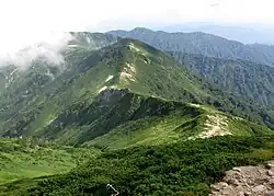
The panhandle is located in the northeast of Fukushima Prefecture on the border with Yamagata Prefecture and Niigata Prefecture. It is part of the city of Kitakata. It is about 8 kilometers (5.0 mi) long, starting from the summit of Mount Mikuni, passing through the summit of Mount Iide, and ending on the summit of Mount Onishi. It is about 90 centimetres (35 in) at its narrowest.[2][3] It follows the ridge of Mount Kengamine.[3]
History
According to Hiromichi Ozawa of the Fukushima Folklore Society, a border dispute starting in 1886 between Fukushima and Niigata, when the Fukushima Prefectural Assembly decided to moved the capital of Fukushima from Fukushima City to Koriyama due to Fukushima City's poor transportation access to the rest of the prefecture during that time. This was stopped by the government by transferring the Higashikanbara District to Niigata. Ichinokimura protested the transfer because the summit of Mount Iide and Mount Iide Shrine were also transferred into Niigata Prefecture. The village presented historical evidence that Mount Iide Shrine was part of the Aizu clan. The border dispute lasted until 1907, when the national government conducted a field survey and officially recognized that the Mount Iide Shrine and the trails leading to the shrine as part of Fukushima, creating the panhandle.[2][4][5][1] The panhandle reaches reaches the summit of Mount Onishi because people during that time believed that the Mount Iide Shrine extended to the summit of the mountain based on emakimono from the Edo period depicts people making a pilgrimage to the Mount Iide Shrine.[3]
Trail
There are two refuge huts located along the panhandle. The mountain trail, where the panhandle runs through, is composed of steep slopes ranging from 100 metres (330 ft) to 200 metres (660 ft) in height, which leads to Mount Iide Shrine at the summit of Mount Iide.[1] It is also a rocky and unpaved trail, which was described by MBS as "a cliff rather than a trail" and challenging to navigate.[3] Takao Nakagawa of Shūkan Gendai Online describes that trail towards the tripoint at the end of the panhandle as the "hardest" to access, comparing it to the Tochigi–Gunma–Saitama border which is the "easiest".[4]
Flora
Lilium rubellum, a species from Liliaceae family can only be found on the area.[6]
See also
References
- ^ a b c Nishimura, Masayuki (December 26, 2024). ""Mōchō kenkyō" no Saiokubu ni wa Nani ga aru? Chizu no "Ki ni naru Tsubo" o Hontōni Aruite mita [Vol. 02 Iidesan Kōhen (Fukushima-ken Kitakata-shi) ]" 「盲腸県境」の最奥部には何がある? 地図の〝気になるツボ〟を本当に歩いてみた【vol.02 飯豊山・後編(福島県喜多方市)】 [What's at the innermost part of the "Appendix Prefectural Border"? We actually walked around the "interesting spot" on the map [Vol. 02 Mt. Iide, Part 2 (Kitakata City, Fukushima Prefecture)]]. Mapple. Shobunsha. Retrieved August 4, 2025.
- ^ a b c "Fukushima ni "Hesonoo" Shōtai wa? Kenkyō Matagu Iidesan e no Michi" 福島に「へその緒」正体は? 県境またぐ飯豊山への道 [What is the true nature of the "umbilical cord" in Fukushima? The road to Mt. Iide across the prefectural border]. The Nikkei (in Japanese). October 20, 2020. Retrieved August 4, 2025.
- ^ a b c d "Habayaku 90 cm! ? Fukushima-ken no "Hosonaga ~ i kenkyō" o Aruite Mitara Igaina Jijitsu ga Hanmei | Nichiyōbi no Hatsumimi-gaku Fukushū-hen" 幅約90cm!?福島県の"細長~い県境"を歩いてみたら意外な事実が判明 | 日曜日の初耳学 復習編 [About 90cm wide!? A walk along Fukushima Prefecture's "long, narrow prefectural border" reveals a surprising fact. | Sunday's First Time Learning Review]. MBS (in Japanese). August 23, 2020. Retrieved August 4, 2025.
- ^ a b Nakagawa, Takao (April 29, 2022). "Nihon'ichi Fushigina Kenkyō! Niigata-ken to Yamagata-ken no ma ni Kuikomu Fukushima-ken! ?" 日本一不思議な県境! 新潟県と山形県の間に食い込む福島県!? [Japan's most mysterious prefectural border! Fukushima Prefecture wedged between Niigata and Yamagata Prefectures!?]. Shūkan Gendai Online (in Japanese). Retrieved August 4, 2025.
- ^ "Iidesan no Rekishi" 飯豊山の歴史 [The history of Mt. Iide]. Kitakata City Government. Archived from the original on November 10, 2014. Retrieved August 4, 2025.
- ^ "Kitakata no Hanameguri - Kitakata-shi Hōmupēji" 喜多方の花めぐり - 喜多方市ホームページ [Flower Tour of Kitakata - Kitakata City Homepage]. www.city.kitakata.fukushima.jp. Retrieved August 4, 2025.