Timeline of the 2025 Pacific hurricane season
| Timeline of the 2025 Pacific hurricane season | |||||
|---|---|---|---|---|---|
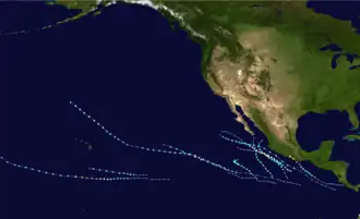 Season summary map | |||||
| Season boundaries | |||||
| First system formed | May 28, 2025 | ||||
| Last system dissipated | Season ongoing | ||||
| Strongest system | |||||
| Name | Erick | ||||
| Maximum winds | 145 mph (230 km/h) | ||||
| Lowest pressure | 939 mbar (hPa; 27.73 inHg) | ||||
| Longest lasting system | |||||
| Name | Henriette | ||||
| Duration | 8.50 days | ||||
| |||||
The 2025 Pacific hurricane season is the current tropical cyclone season in the Pacific Ocean east of the International Date Line (IDL) in the Northern Hemisphere. It officially began on May 15 in the eastern Pacific (east of 140°W), and on June 1 in the central Pacific (from the IDL east to 140°W); it will end in both on November 30. These dates, adopted by convention, historically describe the period in each year when most tropical cyclogenesis occurs in these regions of the Pacific.[1] The season's first system, Tropical Storm Alvin, developed on May 28.
This timeline documents tropical cyclone formations, strengthening, weakening, landfalls, extratropical transitions, and dissipations during the season. It includes information that was not released throughout the season, meaning that data from post-storm reviews by the National Hurricane Center, such as a storm that was not initially warned upon, has been included.
By convention, meteorologists use one time zone when issuing forecasts and making observations: Coordinated Universal Time (UTC), and also use the 24-hour clock (where 00:00 = midnight UTC).[2] Tropical cyclone advisories in the Eastern North Pacific basin use both UTC and the nautical time zone where the center of the tropical cyclone is currently located. Time zones utilized (east to west) are: Central, Mountain, Pacific and Hawaii. In this timeline, all information is listed by UTC first, with the respective regional time zone included in parentheses. Additionally, figures for maximum sustained winds and position estimates are rounded to the nearest 5 units (knots, miles, or kilometers), following National Hurricane Center practice. Direct wind observations are rounded to the nearest whole number. Atmospheric pressures are listed to the nearest millibar and nearest hundredth of an inch of mercury.
Timeline
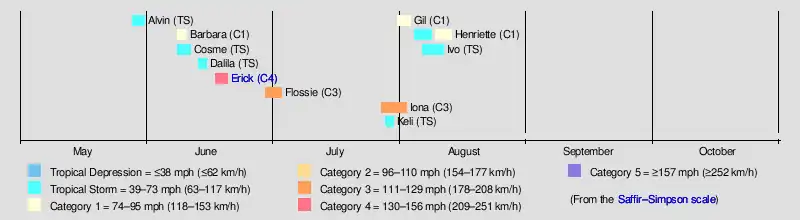
May
May 15
- The Eastern Pacific hurricane season officially begins.[1]
May 28
- 21:00 UTC (3:00 p.m. CST) at 11°54′N 104°42′W / 11.9°N 104.7°W – Tropical Depression One-E forms about 835 mi (1,340 km) south-southeast of the southern tip of the Baja California peninsula.[3]
May 29
- 15:00 UTC (8:00 a.m. MST) at 13°48′N 106°18′W / 13.8°N 106.3°W – Tropical Depression One-E strengthens into Tropical Storm Alvin about 670 mi (1,080 km) south-southeast of the southern tip of the Baja California peninsula.[4]
- 21:00 UTC (2:00 p.m. MST) at 15°06′N 107°12′W / 15.1°N 107.2°W – Tropical Storm Alvin reaches peak intensity with maximum sustained winds of 60 mph (95 km/h) and a minimum central pressure of 999 mbar (29.50 inHg), about 565 mi (910 km) south-southeast of the southern tip of the Baja California peninsula.[5]
May 31
- 15:00 UTC (8:00 a.m. MST) at 20°42′N 109°30′W / 20.7°N 109.5°W – Tropical Storm Alvin degenerates to a remnant low about 155 mi (250 km) south of the southern tip of the Baja California peninsula.[6]
June
June 1
- The Central Pacific hurricane season officially begins.[1]
June 8
- 09:00 UTC (3:00 a.m. CST) at 15°12′N 102°24′W / 15.2°N 102.4°W – Tropical Storm Barbara forms about 180 mi (290 km) south-southwest of Zihuatanejo, Guerrero.[7]
- 15:00 UTC (8:00 a.m. MST) at 12°36′N 110°36′W / 12.6°N 110.6°W – Tropical Depression Three-E forms about 715 mi (1,145 km) south of the southern tip of the Baja California peninsula.[8]
- 21:00 UTC (2:00 p.m. MST) at 13°18′N 111°00′W / 13.3°N 111.0°W – Tropical Depression Three-E strengthens into Tropical Storm Cosme about 665 mi (1,075 km) south of the southern tip of the Baja California peninsula.[9]
June 9
- 15:00 UTC (8:00 a.m. MST) at 17°36′N 106°06′W / 17.6°N 106.1°W – Tropical Storm Barbara strengthens into a Category 1 hurricane and simultaneously reaches peak intensity with maximum sustained winds of 75 mph (120 km/h) and a minimum central pressure of 991 mbar (29.26 inHg), about 155 mi (245 km) southwest of Manzanillo, Colima.[10]
- 21:00 UTC (2:00 p.m. MST) at 15°00′N 113°54′W / 15.0°N 113.9°W – Tropical Storm Cosme reaches peak intensity with maximum sustained winds of 70 mph (110 km/h) and a minimum central pressure of 992 mbar (29.29 inHg), about 605 mi (975 km) south-southwest of the southern tip of the Baja California peninsula.[11]
June 10
- 03:00 UTC (8:00 p.m. MST June 9) at 18°42′N 107°48′W / 18.7°N 107.8°W – Hurricane Barbara weakens to a tropical storm about 230 mi (370 km) west of Manzanillo.[12]
June 11
- 03:00 UTC (8:00 p.m. MST June 10) at 21°12′N 108°00′W / 21.2°N 108.0°W – Tropical Storm Barbara degenerates to a remnant low about 160 mi (255 km) west-northwest of Cabo Corrientes, Jalisco.[13]
- 15:00 UTC (8:00 a.m. MST) at 16°24′N 113°42′W / 16.4°N 113.7°W – Tropical Storm Cosme degenerates to a remnant low about 510 mi (825 km) south-southwest of the southern tip of the Baja California peninsula.[14]
June 13
- 15:00 UTC (9:00 a.m. CST) at 13°54′N 101°36′W / 13.9°N 101.6°W – Tropical Depression Four-E forms about 260 mi (420 km) south of Zihuatanejo, Guerrero.[nb 1][16]
- 18:00 UTC (12:00 p.m. CST) at 14°30′N 101°48′W / 14.5°N 101.8°W – Tropical Depression Four-E strengthens into Tropical Storm Dalila about 195 mi (315 km) south of Zihuatanejo.[17]
June 14
- 18:00 UTC (12:00 p.m. CST) at 16°36′N 105°06′W / 16.6°N 105.1°W – Tropical Storm Dalila reaches peak intensity with maximum sustained winds of 65 mph (100 km/h) and a minimum central pressure of 993 mbar (29.32 inHg), about 170 mi (280 km) south-southwest of Manzanillo, Colima.[18]
June 16
- 03:00 UTC (8:00 p.m. MST June 15) at 18°36′N 109°12′W / 18.6°N 109.2°W – Tropical Storm Dalila transitions to a post-tropical cyclone about 320 mi (515 km) west of Manzanillo.[19]
June 17
- 03:00 UTC (9:00 p.m. CST June 16) at 11°12′N 92°36′W / 11.2°N 92.6°W – Tropical Depression Five-E forms about 535 mi (860 km) southeast of Punta Maldonado, Guerrero.[nb 2][21]
- 09:00 UTC (3:00 a.m. CST) at 11°54′N 93°36′W / 11.9°N 93.6°W – Tropical Depression Five-E strengthens into Tropical Storm Erick about 450 mi (725 km) southeast of Punta Maldonado.[22]
June 18
- 12:00 UTC (6:00 a.m. CST) at 13°30′N 95°42′W / 13.5°N 95.7°W – Tropical Storm Erick strengthens into a Category 1 hurricane about 160 mi (255 km) south-southeast of Puerto Ángel, Oaxaca.[23]
- 18:00 UTC (12:00 p.m. CST) at 14°12′N 96°18′W / 14.2°N 96.3°W – Hurricane Erick intensifies to Category 2 strength about 105 mi (165 km) south of Puerto Ángel.[24]
June 19
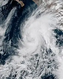
- 00:00 UTC (6:00 p.m. CST June 18) at 14°54′N 96°42′W / 14.9°N 96.7°W – Hurricane Erick intensifies to Category 3 strength about 55 mi (90 km) south-southwest of Puerto Ángel.[25]
- 05:40 UTC (11:40 p.m. CST June 18) – Hurricane Erick intensifies to Category 4 strength.[26]
- 06:00 UTC (12:00 a.m. CST) at 15°30′N 97°30′W / 15.5°N 97.5°W – Hurricane Erick reaches peak intensity with maximum sustained winds of 145 mph (230 km/h) and a minimum central pressure of 939 mbar (27.73 inHg), about 70 mi (110 km) west-southwest of Puerto Ángel.[27]
- 12:00 UTC (6:00 a.m. CST) at 16°18′N 98°18′W / 16.3°N 98.3°W – Hurricane Erick weakens to Category 3 strength and simultaneously makes landfall in extreme western Oaxaca with sustained winds of 125 mph (205 km/h), about 20 mi (30 km) east of Punta Maldonado, Guerrero.[28]
- 15:00 UTC (9:00 a.m. CST) at 16°42′N 98°48′W / 16.7°N 98.8°W – Hurricane Erick rapidly weakens to Category 1 strength inland, about 30 mi (50 km) north-northwest of Punta Maldonado.[29]
- 21:00 UTC (3:00 p.m. CST) at 17°24′N 99°42′W / 17.4°N 99.7°W – Hurricane Erick weakens to a tropical storm inland, about 35 mi (60 km) north-northeast of Acapulco, Guerrero.[30]
June 20
- 00:00 UTC (6:00 p.m. CST June 19) at 17°42′N 100°12′W / 17.7°N 100.2°W – Tropical Storm Erick weakens to a tropical depression inland, about 60 mi (95 km) north-northwest of Acapulco.[31]
- 03:00 UTC (9:00 p.m. CST June 19) at 18°00′N 100°48′W / 18.0°N 100.8°W – Tropical Depression Erick decays to an area of low pressure inland, about 95 mi (155 km) northwest of Acapulco.[32]
June 29
- 09:00 UTC (3:00 a.m. CST) at 13°00′N 99°30′W / 13.0°N 99.5°W – Tropical Depression Six-E forms about 270 mi (435 km) south of Acapulco, Guerrero.[33]
- 15:00 UTC (9:00 a.m. CST) at 13°24′N 99°54′W / 13.4°N 99.9°W – Tropical Depression Six-E strengthens into Tropical Storm Flossie about 240 mi (390 km) south of Acapulco.[34]
July
July 1
- 03:00 UTC (9:00 p.m. CST June 30) at 16°30′N 104°18′W / 16.5°N 104.3°W – Tropical Storm Flossie strengthens into a Category 1 hurricane about 175 mi (280 km) south of Manzanillo, Colima.[35]
- 15:00 UTC (9:00 a.m. CST) at 17°24′N 105°54′W / 17.4°N 105.9°W – Hurricane Flossie intensifies to Category 2 strength about 150 mi (245 km) southwest of Manzanillo.[36]
July 2
- 03:00 UTC (8:00 p.m. MST July 1) at 18°12′N 107°24′W / 18.2°N 107.4°W – Hurricane Flossie intensifies to Category 3 strength and simultaneously reaches peak intensity with maximum sustained winds of 115 mph (185 km/h) and a minimum central pressure of 962 mbar (28.41 inHg), about 210 mi (340 km) west-southwest of Manzanillo.[37]
- 15:00 UTC (8:00 a.m. MST) at 19°00′N 109°00′W / 19.0°N 109.0°W – Hurricane Flossie weakens to Category 2 strength about 275 mi (445 km) south-southeast of Cabo San Lucas, Baja California Sur.[38]
July 3
- 03:00 UTC (8:00 p.m. MST July 2) at 19°48′N 110°12′W / 19.8°N 110.2°W – Hurricane Flossie weakens to Category 1 strength about 215 mi (345 km) south of Cabo San Lucas.[39]
- 09:00 UTC (2:00 a.m. MST) at 20°06′N 111°00′W / 20.1°N 111.0°W – Hurricane Flossie weakens to a tropical storm about 205 mi (330 km) south-southwest of Cabo San Lucas.[40]
- 21:00 UTC (2:00 p.m. MST) at 21°12′N 112°24′W / 21.2°N 112.4°W – Tropical Storm Flossie transitions to a post-tropical cyclone about 200 mi (320 km) southwest of Cabo San Lucas.[41]
July 27
- 09:00 UTC (11:00 p.m. HST July 26) at 10°54′N 145°36′W / 10.9°N 145.6°W – Tropical Depression One-C forms about 1,085 mi (1,745 km) southeast of Honolulu, Hawaii.[42]
July 28
- 03:00 UTC (5:00 p.m. HST July 27) at 10°54′N 148°18′W / 10.9°N 148.3°W – Tropical Depression One-C strengthens into Tropical Storm Iona about 960 mi (1,545 km) southeast of Honolulu.[43]
- 15:00 UTC (5:00 a.m. HST) at 10°42′N 150°06′W / 10.7°N 150.1°W – Tropical Storm Iona strengthens into a Category 1 hurricane about 895 mi (1,440 km) southeast of Honolulu.[44]
- 15:00 UTC (5:00 a.m. HST) at 12°00′N 143°36′W / 12.0°N 143.6°W – Tropical Depression Two-C forms about 1,140 mi (1,840 km) east-southeast of Honolulu, Hawaii.[45]
- 21:00 UTC (11:00 a.m. HST) at 12°06′N 144°30′W / 12.1°N 144.5°W – Tropical Depression Two-C strengthens into Tropical Storm Keli about 1,090 mi (1,755 km) southeast of Honolulu.[46]
July 29
- 09:00 UTC (11:00 p.m. HST July 28) at 10°48′N 153°12′W / 10.8°N 153.2°W – Hurricane Iona rapidly intensifies to Category 3 strength about 790 mi (1,270 km) south-southeast of Honolulu.[47]
- 09:00 UTC (11:00 p.m. HST July 28) at 12°30′N 146°36′W / 12.5°N 146.6°W – Tropical Storm Keli reaches peak intensity with maximum sustained winds of 40 mph (65 km/h) and a minimum central pressure of 1006 mbar (29.71 inHg), about 960 mi (1,550 km) southeast of Honolulu.[48]
- 15:00 UTC (5:00 a.m. HST) at 10°48′N 154°18′W / 10.8°N 154.3°W – Hurricane Iona reaches peak intensity with maximum sustained winds of 125 mph (205 km/h) and a minimum central pressure of 957 mbar (28.26 inHg), about 765 mi (1,230 km) south-southeast of Honolulu.[49]
July 30
- 09:00 UTC (11:00 p.m. HST July 29) at 11°18′N 158°36′W / 11.3°N 158.6°W – Hurricane Iona weakens to Category 2 strength about 690 mi (1,115 km) south of Honolulu.[50]
- 15:00 UTC (5:00 a.m. HST) at 11°30′N 160°12′W / 11.5°N 160.2°W – Hurricane Iona weakens to Category 1 strength about 695 mi (1,115 km) south-southwest of Honolulu.[51]
- 21:00 UTC (11:00 a.m. HST) at 11°42′N 162°36′W / 11.7°N 162.6°W – Hurricane Iona weakens to a tropical storm about 730 mi (1,180 km) south-southwest of Honolulu.[52]
- 21:00 UTC (11:00 a.m. HST) at 13°54′N 156°36′W / 13.9°N 156.6°W – Tropical Storm Keli opens into a trough about 520 mi (835 km) south of Honolulu.[53]
July 31
- 09:00 UTC (11:00 p.m. HST July 30) at 12°42′N 115°06′W / 12.7°N 115.1°W – Tropical Storm Gil forms about 785 mi (1,260 km) south-southwest of the southern tip of the Baja California peninsula.[54]
August
August 2
- 03:00 UTC (5:00 p.m. HST, August 1) at 15°48′N 179°30′W / 15.8°N 179.5°W – Tropical Storm Iona weakens to a tropical depression and simultaneously crosses the International Date Line, exiting the Central Pacific basin, about 1,465 mi (2,355 km) west of Honolulu.[55]
- 03:00 UTC (5:00 p.m. HST, August 1) at 16°30′N 125°06′W / 16.5°N 125.1°W – Tropical Storm Gil strengthens into a Category 1 hurricane and simultaneously reaches peak intensity with maximum sustained winds of 75 mph (120 km/h) and a minimum central pressure of 991 mbar (29.26 inHg), about 1,080 mi (1,740 km) west-southwest of the southern tip of the Baja California peninsula.[56]
- 15:00 UTC (5:00 a.m. HST) at 18°18′N 128°36′W / 18.3°N 128.6°W – Hurricane Gil weakens to a tropical storm about 1,250 mi (2,010 km) west of the southern tip of the Baja California peninsula.[57]
August 3
- 15:00 UTC (5:00 a.m. HST) at 20°36′N 135°42′W / 20.6°N 135.7°W – Tropical Storm Gil transitions to a post-tropical cyclone about 1,660 mi (2,670 km) west of the southern tip of the Baja California peninsula.[58]
August 4
- 09:00 UTC (11:00 p.m. HST, August 3) at 13°42′N 118°12′W / 13.7°N 118.2°W – Tropical Depression Eight-E forms about 835 mi (1,345 km) southwest of the southern tip of the Baja California peninsula.[59]
- 21:00 UTC (11:00 a.m. HST) at 14°48′N 120°36′W / 14.8°N 120.6°W – Tropical Depression Eight-E strengthens into Tropical Storm Henriette about 895 mi (1,440 km) southwest of the southern tip of the Baja California peninsula.[60]
August 5
- 03:00 UTC (5:00 p.m. HST, August 4) at 15°24′N 121°54′W / 15.4°N 121.9°W – Tropical Storm Henriette reaches its initial peak intensity, with sustained winds of 50 mph (85 km/h) and a central pressure of 1001 mbar (29.56 inHg), about 940 mi (1,510 km) west-southwest of the southern tip of the Baja California peninsula.[61]
August 8
- 21:00 UTC (11:00 a.m. HST) at 19°54′N 143°00′W / 19.9°N 143.0°W – Tropical Storm Henriette degenerates into a remnant low about 785 mi (1,265 km) east of Hilo, Hawaii.[62]
August 9
- 09:00 UTC (11:00 p.m. HST, August 8) at 20°42′N 145°42′W / 20.7°N 145.7°W – The remnants of Tropical Storm Henriette regenerate into a tropical depression[63] about 615 mi (985 km) east of Hilo.[64]
- 21:00 UTC (11:00 a.m. HST) at 22°18′N 148°06′W / 22.3°N 148.1°W – Tropical Depression Henriette restrengthens into a tropical storm about 485 mi (780 km) east-northeast of Hilo.[65]
August 10
- 21:00 UTC (11:00 a.m. HST) at 25°42′N 152°30′W / 25.7°N 152.5°W – Tropical Storm Henriette strengthens into a Category 1 hurricane about 445 mi (720 km) north-northeast of Hilo.[66]
August 11
- 15:00 UTC (5:00 a.m. HST) at 28°48′N 156°30′W / 28.8°N 156.5°W – Hurricane Henriette reaches its peak intensity, with maximum sustained winds of 85 mph (140 km/h) and a minimum central pressure of 986 mbar (29.12 inHg), about 525 mi (845 km) north of Honolulu.[67]
August 12
- 15:00 UTC (5:00 a.m. HST) at 32°48′N 161°36′W / 32.8°N 161.6°W – Hurricane Henriette weakens into a tropical storm about 825 mi (1,335 km) north-northwest of Honolulu.[68]
August 13
- 09:00 UTC (11:00 p.m. HST, August 12) at 36°42′N 165°36′W / 36.7°N 165.6°W – Tropical Storm Henriette transitions into a post-tropical cyclone about 1,160 mi (1,865 km) north-northwest of Honolulu.[69]
November
November 30
- The 2025 Pacific hurricane season officially ends in the Eastern and Central Pacific basins.[1]
See also
Notes
- ^ Due to the threat the developing system posed to southwestern Mexico, the National Hurricane Center initiated advisories on it, designating it Potential Tropical Cyclone Four-E at 21:00 UTC (3:00 p.m. CST) on June 12.[15]
- ^ Due to the threat the developing system posed to southern Mexico, the National Hurricane Center initiated advisories on it, designating it Potential Tropical Cyclone Five-E at 21:00 UTC (3:00 p.m. CST) on June 16.[20]
References
- ^ a b c d "Hurricanes Frequently Asked Questions". Miami, Florida: Atlantic Oceanographic and Meteorological Laboratory. June 1, 2023. Retrieved June 2, 2025.
- ^ "Understanding the Date/Time Stamps". Miami, Florida: National Hurricane Center. Retrieved June 2, 2025.
- ^ Kelly, Larry; Mora, Cassandra (May 28, 2025). Tropical Depression One-E Advisory Number 1 (Report). Miami, Florida: National Hurricane Center. Retrieved June 2, 2025.
- ^ Mora, Cassandra; Cangialosi, John (May 29, 2025). Tropical Storm Alvin Advisory Number 4 (Report). Miami, Florida: National Hurricane Center. Retrieved June 2, 2025.
- ^ Kelly, Larry; Mora, Cassandra (May 29, 2025). Tropical Storm Alvin Advisory Number 5 (Report). Miami, Florida: National Hurricane Center. Retrieved June 2, 2025.
- ^ Brown, Daniel (May 31, 2025). Post-Tropical Cyclone Alvin Advisory Number 12 (Report). Miami, Florida: National Hurricane Center. Retrieved June 2, 2025.
- ^ Reinhart, Brad (June 8, 2025). Tropical Storm Barbara Advisory Number 1 (Report). Miami, Florida: National Hurricane Center. Retrieved June 8, 2025.
- ^ Jelsema, Jon; Cangialosi, John (June 8, 2025). Tropical Depression Three-E Advisory Number 1 (Report). Miami, Florida: National Hurricane Center. Retrieved June 8, 2025.
- ^ Cangialosi, John (June 8, 2025). Tropical Storm Cosme Advisory Number 2 (Report). Miami, Florida: National Hurricane Center. Retrieved June 8, 2025.
- ^ Kelly, Larry; Adams, Elizabeth (June 9, 2025). Hurricane Barbara Advisory Number 6 (Report). Miami, Florida: National Hurricane Center. Retrieved June 9, 2025.
- ^ Cangialosi, John (June 9, 2025). Tropical Storm Cosme Advisory Number 6 (Report). Miami, Florida: National Hurricane Center. Retrieved June 10, 2025.
- ^ Pasch, Richard (June 10, 2025). Tropical Storm Barbara Advisory Number 8 (Report). Miami, Florida: National Hurricane Center. Retrieved June 10, 2025.
- ^ Pasch, Richard (June 11, 2025). Post-Tropical Cyclone Barbara Advisory Number 12 (Report). Miami, Florida: National Hurricane Center. Retrieved June 10, 2025.
- ^ Kelly, Larry; Gibbs, Alex (June 11, 2025). Post-Tropical Cyclone Cosme Advisory Number 13 (Report). Miami, Florida: National Hurricane Center. Retrieved June 11, 2025.
- ^ Kelly, Larry (June 12, 2025). Potential Tropical Cyclone Four-E Advisory Number 1 (Report). Miami, Florida: National Hurricane Center. Retrieved June 13, 2025.
- ^ Kelly, Larry (June 13, 2025). Tropical Depression Four-E Advisory Number 4 (Report). Miami, Florida: National Hurricane Center. Retrieved June 13, 2025.
- ^ Kelly, Larry (June 13, 2025). Tropical Storm Dalila Intermediate Advisory Number 4A (Report). Miami, Florida: National Hurricane Center. Retrieved June 13, 2025.
- ^ Kelly, Larry (June 14, 2025). Tropical Storm Dalila Intermediate Advisory Number 8A (Report). Miami, Florida: National Hurricane Center. Retrieved June 15, 2025.
- ^ Zelinksy, David (June 16, 2025). Post-Tropical Cyclone Dalila Advisory Number 14 (Report). Miami, Florida: National Hurricane Center. Retrieved June 15, 2025.
- ^ Bucci, Lisa; Mora, Cassandra; Cano, Will (June 16, 2025). Potential Tropical Cyclone Five-E Advisory Number 1 (Report). Miami, Florida: National Hurricane Center. Retrieved June 17, 2025.
- ^ Cangialosi, John (June 17, 2025). Tropical Depression Five-E Advisory Number 2 (Report). Miami, Florida: National Hurricane Center. Retrieved June 17, 2025.
- ^ Pasch, Richard; Gibbs, Alex; Jelsema, John. Tropical Storm Erick Advisory Number 3 (Report). Miami, Florida: National Hurricane Center. Retrieved June 17, 2025.
- ^ Hagen, Andrew (June 18, 2025). Hurricane Erick Intermediate Advisory Number 7A (Report). Miami, Florida: National Hurricane Center. Retrieved June 18, 2025.
- ^ Hagen, Andrew (June 18, 2025). Hurricane Erick Intermediate Advisory Number 8A (Report). Miami, Florida: National Hurricane Center. Retrieved June 18, 2025.
- ^ Beven, Jack (June 19, 2025). Hurricane Erick Intermediate Advisory Number 9A (Report). Miami, Florida: National Hurricane Center. Retrieved June 18, 2025.
- ^ Kelly, Larry (June 18, 2025). Hurricane Erick Tropical Cyclone Update (Report). Miami, Florida: National Hurricane Center. Retrieved June 19, 2025.
- ^ Pasch, Richard (June 19, 2025). Hurricane Erick Special Advisory Number 11 (Report). Miami, Florida: National Hurricane Center. Retrieved June 19, 2025.
- ^ Cangialosi, John (June 19, 2025). Hurricane Erick Intermediate Advisory Number 12A (Report). Miami, Florida: National Hurricane Center. Retrieved June 19, 2025.
- ^ Cangialosi, John (June 19, 2025). Hurricane Erick Advisory Number 13 (Report). Miami, Florida: National Hurricane Center. Retrieved June 19, 2025.
- ^ Cangialosi, John (June 19, 2025). Tropical Storm Erick Advisory Number 14 (Report). Miami, Florida: National Hurricane Center. Retrieved June 19, 2025.
- ^ Beven, Jack (June 20, 2025). Tropical Depression Erick Intermediate Advisory Number 14A (Report). Miami, Florida: National Hurricane Center. Retrieved June 19, 2025.
- ^ Beven, Jack (June 20, 2025). Post-Tropical Cyclone Erick Advisory Number 15 (Report). Miami, Florida: National Hurricane Center. Retrieved June 19, 2025.
- ^ Hagen, Andrew (June 29, 2025). Tropical Depression Six-E Advisory Number 1 (Report). Miami, Florida: National Hurricane Center. Retrieved June 29, 2025.
- ^ Kelly, Larry (June 29, 2025). Tropical Storm Flossie Advisory Number 2 (Report). Miami, Florida: National Hurricane Center. Retrieved June 29, 2025.
- ^ Jelsema, Jon (July 1, 2025). Hurricane Flossie Advisory Number 8 (Report). Miami, Florida: National Hurricane Center. Retrieved July 1, 2025.
- ^ Beven, Jack (July 1, 2025). Hurricane Flossie Advisory Number 10 (Report). Miami, Florida: National Hurricane Center. Retrieved July 1, 2025.
- ^ Bucci, Lisa (July 2, 2025). Hurricane Flossie Advisory Number 12 (Report). Miami, Florida: National Hurricane Center. Retrieved July 2, 2025.
- ^ Kelly, Larry (July 2, 2025). Hurricane Flossie Advisory Number 14 (Report). Miami, Florida: National Hurricane Center. Retrieved July 2, 2025.
- ^ Gibbs, Alex; Jelsema, Jon; Blake, Eric (July 3, 2025). Hurricane Flossie Advisory Number 16 (Report). Miami, Florida: National Hurricane Center. Retrieved July 3, 2025.
- ^ Gibbs, Alex; Jelsema, Jon; Papin, Philippe (July 3, 2025). Tropical Storm Flossie Advisory Number 17 (Report). Miami, Florida: National Hurricane Center. Retrieved July 3, 2025.
- ^ Cangialosi, John (July 3, 2025). Post-Tropical Cyclone Flossie Advisory Number 19 (Report). Miami, Florida: National Hurricane Center. Retrieved July 3, 2025.
- ^ Jelsema, Jon (July 27, 2025). Tropical Depression One-C Advisory Number 1 (Report). Miami, Florida: National Hurricane Center. Retrieved July 27, 2025.
- ^ Jelsema, Jon (July 28, 2025). Tropical Storm Iona Advisory Number 4 (Report). Miami, Florida: National Hurricane Center. Retrieved July 28, 2025.
- ^ Brown, Daniel (July 28, 2025). Hurricane Iona Advisory Number 6 (Report). Miami, Florida: National Hurricane Center. Retrieved July 28, 2025.
- ^ Cangialosi, John (July 28, 2025). Tropical Depression Two-C Advisory Number 1 (Report). Miami, Florida: National Hurricane Center. Retrieved July 28, 2025.
- ^ Cangialosi, John (July 28, 2025). Tropical Storm Keli Advisory Number 2 (Report). Miami, Florida: National Hurricane Center. Retrieved July 28, 2025.
- ^ Jelsema, Jon (July 29, 2025). Hurricane Iona Advisory Number 9 (Report). Miami, Florida: National Hurricane Center. Retrieved July 29, 2025.
- ^ Kelly, Larry (July 29, 2025). Tropical Storm Keli Advisory Number 4 (Report). Miami, Florida: National Hurricane Center. Retrieved July 30, 2025.
- ^ Cangialosi, John (July 29, 2025). Hurricane Iona Advisory Number 10 (Report). Miami, Florida: National Hurricane Center. Retrieved July 30, 2025.
- ^ Jelsema, Jon (July 30, 2025). Hurricane Iona Advisory Number 13 (Report). Miami, Florida: National Hurricane Center. Retrieved July 30, 2025.
- ^ Beven, Jack (July 30, 2025). Hurricane Iona Advisory Number 14 (Report). Miami, Florida: National Hurricane Center. Retrieved July 30, 2025.
- ^ Beven, Jack (July 30, 2025). Tropical Storm Iona Advisory Number 15 (Report). Miami, Florida: National Hurricane Center. Retrieved July 30, 2025.
- ^ Bucci, Lisa (July 30, 2025). Remnants of Keli Advisory Number 10 (Report). Miami, Florida: National Hurricane Center. Retrieved July 30, 2025.
- ^ Hagen, Andrew (July 31, 2025). Tropical Storm Gil Advisory Number 1 (Report). Miami, Florida: National Hurricane Center. Retrieved July 31, 2025.
- ^ Gibbs, Alex (August 2, 2025). Tropical Depression Iona Advisory Number 24 (Report). Miami, Florida: National Hurricane Center. Retrieved August 2, 2025.
- ^ Berg, Robbie (August 2, 2025). Hurricane Gil Advisory Number 8 (Report). Miami, Florida: National Hurricane Center. Retrieved August 2, 2025.
- ^ Beven, Jack (August 2, 2025). Tropical Storm Gil Advisory Number 10 (Report). Miami, Florida: National Hurricane Center. Retrieved August 2, 2025.
- ^ Gibbs, Alex (August 3, 2025). Post-Tropical Cyclone Gil Advisory Number 14 (Report). Miami, Florida: National Hurricane Center. Retrieved August 3, 2025.
- ^ Gibbs, Alex (August 4, 2025). Tropical Depression Eight-E Advisory Number 1 (Report). Miami, Florida: National Hurricane Center. Retrieved August 4, 2025.
- ^ Roberts, Dave (August 4, 2025). Tropical Storm Henriette Advisory Number 3 (Report). Miami, Florida: National Hurricane Center. Retrieved August 4, 2025.
- ^ Jelsema, Jon (August 4, 2025). Tropical Storm Henriette Advisory Number 4 (Report). Honolulu, Hawaii: Central Pacific Hurricane Center. Retrieved August 12, 2025.
- ^ Hagen, Andrew (August 8, 2025). Post-Tropical Cyclone Henriette Advisory Number 19 (Report). Miami, Florida: National Hurricane Center. Retrieved August 12, 2025.
- ^ Gibbs, Andy (August 8, 2025). Tropical Depression Henriette Discussion Number 21 (Report). Miami, Florida: National Hurricane Center. Retrieved August 12, 2025.
- ^ Gibbs, Andy (August 8, 2025). Tropical Depression Henriette Advisory Number 21 (Report). Miami, Florida: National Hurricane Center. Retrieved August 12, 2025.
- ^ Hagen, Andrew (August 9, 2025). Tropical Storm Henriette Advisory Number 23 (Report). Miami, Florida: National Hurricane Center. Retrieved August 12, 2025.
- ^ Blake, Eric (August 10, 2025). Hurricane Henriette Advisory Number 27 (Report). Miami, Florida: National Hurricane Center. Retrieved August 12, 2025.
- ^ Berg, Robbie (August 11, 2025). Hurricane Henriette Advisory Number 30 (Report). Miami, Florida: National Hurricane Center. Retrieved August 12, 2025.
- ^ Brown, Daniel; Adams, Elizabeth (August 12, 2025). Tropical Storm Henriette Advisory Number 34 (Report). Miami, Florida: National Hurricane Center. Retrieved August 12, 2025.
- ^ Kelly, Larry (August 12, 2025). Post-Tropical Cyclone Henriette Advisory Number 37 (Report). Miami, Florida: National Hurricane Center. Retrieved August 13, 2025.
External links
- 2025 Tropical Cyclone Advisory Archive, National Hurricane Center and Central Pacific Hurricane Center, noaa.gov