Stráňavy
Stráňavy | |
|---|---|
.jpg) | |
 Flag 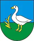 Coat of arms | |
 Stráňavy Location of Stráňavy in the Žilina Region  Stráňavy Location of Stráňavy in Slovakia | |
| Coordinates: 49°11′N 18°49′E / 49.18°N 18.82°E | |
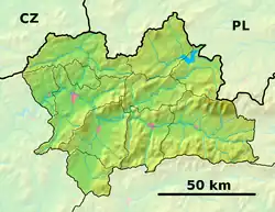
| Country | |
| Region | |
| District | Žilina District |
| First mentioned | 1356 |
| Area | |
• Total | 10.87 km2 (4.20 sq mi) |
| Elevation | 425 m (1,394 ft) |
| Population (2021)[3] | |
• Total | 1,909 |
| Time zone | UTC+1 (CET) |
| • Summer (DST) | UTC+2 (CEST) |
| Postal code | 132 5[2] |
| Area code | +421 41[2] |
| Car plate | ZA |
| Website | www |
Stráňavy (Hungarian: Felsőosztorány) is a village and municipality in Žilina District in the Žilina Region of northern Slovakia. It lies below the mountain Polom.
History
In historical records the village was first mentioned in 1356. The coat-of-arms and the seal picture a bird feeding in a meadow.
Since 1598, the village has grown from 22 houses to 430 houses and counts presently 1,838 inhabitants. Stranavy has a well-developed social and technical infrastructure and pays much attention to tourism. There is a thermal bath (24-26 °C), accommodation and food facilities.
Geography
The municipality lies at an elevation of 420 metres and covers an area of 10.872 km². It has a population of about 1,838.
References
- ^ "Hustota obyvateľstva - obce [om7014rr_ukaz: Rozloha (Štvorcový meter)]". www.statistics.sk (in Slovak). Statistical Office of the Slovak Republic. 2022-03-31. Retrieved 2022-03-31.
- ^ a b c "Základná charakteristika". www.statistics.sk (in Slovak). Statistical Office of the Slovak Republic. 2015-04-17. Retrieved 2022-03-31.
- ^ "Počet obyvateľov podľa pohlavia - obce (ročne)". www.statistics.sk (in Slovak). Statistical Office of the Slovak Republic. 2022-03-31. Retrieved 2022-03-31.