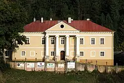
Lietavská Lúčka
Lietavská Lúčka | |
|---|---|
 | |
 Flag | |
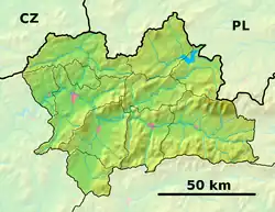 Lietavská Lúčka Location of Lietavská Lúčka in the Žilina Region  Lietavská Lúčka Location of Lietavská Lúčka in Slovakia | |
| Coordinates: 49°10′N 18°43′E / 49.17°N 18.72°E | |
| Country | |
| Region | |
| District | Žilina District |
| First mentioned | 1393 |
| Area | |
• Total | 6.50 km2 (2.51 sq mi) |
| Elevation | 363 m (1,191 ft) |
| Population (2021)[3] | |
• Total | 1,879 |
| Time zone | UTC+1 (CET) |
| • Summer (DST) | UTC+2 (CEST) |
| Postal code | 131 1[2] |
| Area code | +421 41[2] |
| Car plate | ZA |
| Website | www |
Lietavská Lúčka (Hungarian: Litvailló) is a village and municipality in Žilina District in the Žilina Region of northern Slovakia.
History
In historical records the village was first mentioned in 1393.
Geography
The municipality lies at an altitude of 370 metres (1,210 ft) and covers an area of 6.496 km2 (2.508 sq mi). It has a population of about 1769 people. It has a large gender imbalance with women outnumbering men almost 2 to 1.
References
- ^ "Hustota obyvateľstva - obce [om7014rr_ukaz: Rozloha (Štvorcový meter)]". www.statistics.sk (in Slovak). Statistical Office of the Slovak Republic. 2022-03-31. Retrieved 2022-03-31.
- ^ a b c "Základná charakteristika". www.statistics.sk (in Slovak). Statistical Office of the Slovak Republic. 2015-04-17. Retrieved 2022-03-31.
- ^ "Počet obyvateľov podľa pohlavia - obce (ročne)". www.statistics.sk (in Slovak). Statistical Office of the Slovak Republic. 2022-03-31. Retrieved 2022-03-31.