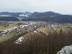
Belá, Žilina District
Belá | |
|---|---|
 | |
 Flag  Coat of arms | |
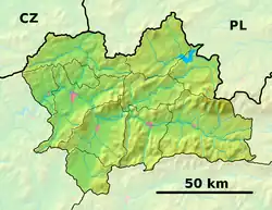 Belá Location of Belá in the Žilina Region  Belá Location of Belá in Slovakia | |
| Coordinates: 49°14′7″N 18°56′44″E / 49.23528°N 18.94556°E | |
| Country | |
| Region | |
| District | Žilina District |
| First mentioned | 1378 |
| Area | |
• Total | 38.61 km2 (14.91 sq mi) |
| Elevation | 494 m (1,621 ft) |
| Population (2021)[3] | |
• Total | 3,297 |
| Time zone | UTC+1 (CET) |
| • Summer (DST) | UTC+2 (CEST) |
| Postal code | 130 5[2] |
| Area code | +421 41[2] |
| Car plate | ZA |
| Website | www |
Belá (Hungarian: Bella) is a village and municipality in Žilina District in the Žilina Region of northern Slovakia.
Genealogical resources
The records for genealogical research are available at the state archive "Statny Archiv in Bytca, Slovakia"
- Roman Catholic church records (births/marriages/deaths): 1686-1899 (parish A)
See also
References
- ^ "Hustota obyvateľstva - obce [om7014rr_ukaz: Rozloha (Štvorcový meter)]". www.statistics.sk (in Slovak). Statistical Office of the Slovak Republic. 2022-03-31. Retrieved 2022-03-31.
- ^ a b c "Základná charakteristika". www.statistics.sk (in Slovak). Statistical Office of the Slovak Republic. 2015-04-17. Retrieved 2022-03-31.
- ^ "Počet obyvateľov podľa pohlavia - obce (ročne)". www.statistics.sk (in Slovak). Statistical Office of the Slovak Republic. 2022-03-31. Retrieved 2022-03-31.
External links