Shirgah
Shirgah
Persian: شيرگاه | |
|---|---|
City | |
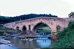 Shahpur Bridge, Shirgah | |
 Shirgah | |
| Coordinates: 36°18′06″N 52°52′55″E / 36.30167°N 52.88194°E[1] | |
| Country | Iran |
| Province | Mazandaran |
| County | North Savadkuh |
| District | Central |
| Population (2016)[2] | |
• Total | 8,671 |
| Time zone | UTC+3:30 (IRST) |
Shirgah (Persian: شيرگاه)[a] is a city in the Central District of North Savadkuh County, Mazandaran province, Iran, serving as capital of both the county and the district.[4] The road connecting Tehran to Qaem Shahr passes through the city, as does the railway from Tehran to the north.
Demographics
Population
At the time of the 2006 National Census, the city's population was 8,529 in 2,269 households,[5] when it was capital of the former Shirgah District of Savadkuh County.[6] The following census in 2011 counted 8,129 people in 2,439 households.[7] The 2016 census measured the population of the city as 8,671 people in 2,869 households,[2] by which time the district had separated from the county in the establishment of North Savadkuh County. Shirgah was transferred to the new Central District as the county's capital.[4]
Economy and Geography
The occupation of most people in this area is agriculture and farming, because this area is surrounded by mountains on all sides except for the fields in the north and has fertile lands. Its mountains are called Terez in the west, Veresk in the east, and Sāre-Sar and Shah-Kuh in the south. Shirgāh is the confluence of two rivers of Mazandaran, Telar and Kaslian. Telar originates from the slopes of Gāduk. The occupation of the people of this city is logging and animal husbandry. During the commute to the forests of this area, the gradual migration of people to Shirgāh led to the construction of small houses that became their permanent homes. People settled in the current city and its slopes, which led to the creation of the initial center of Shirgāh.
There are only three factories in this city. Wood industries, one in Chali, Pichkoban in Sartepeh, and the wood impregnation factory, which was established in 1932 AD (1311 solar year) and its production is limited due to the less use of wooden bars in the railway. This factory was the first wood impregnation factory in Iran.
Because of the many valleys and bridges, Shirgah is called the city of bridges. Of these bridges, the most famous are the Dokhtar Bridge (in Chali), the historical Shah Abbas Bridge (built during the Safavid era), the Abdange Sar Bridge (on the Ghaemshahr road), and the Shahpur Bridge. Several other bridges have also been built, such as the railway bridge in Sartepeh, two bridges in the city, on the Ghaemshahr road, and outside the city.
History
It seems that this city does not have much historical history, because the early inhabitants of this city lived in Chali and Sartepeh, and especially in Abdange Sar. The inhabitants of this city built their houses on highlands so that they could defend themselves against thieves and rebels.
During the time of Reza Khan, a brave man named Hezhbar Sultan fought with Reza Khan and sometimes entered Shirgah to take food, clothes, etc. from the people. During World War II, some Russian troops settled in a small section near Kaligkhel (Shirgah village), who later came to Rusabad to resupply and rebuild.
See also
Notes
References
- ^ OpenStreetMap contributors (22 October 2024). "Shirgah, North Savadkuh County" (Map). OpenStreetMap (in Persian). Retrieved 22 October 2024.
- ^ a b Census of the Islamic Republic of Iran, 1395 (2016): Mazandaran Province. amar.org.ir (Report) (in Persian). The Statistical Center of Iran. Archived from the original (Excel) on 7 October 2021. Retrieved 19 December 2022.
- ^ Shirgah can be found at GEOnet Names Server, at this link, by opening the Advanced Search box, entering "-3085029" in the "Unique Feature Id" form, and clicking on "Search Database".
- ^ a b Rahimi, Mohammadreza (20 April 2012). "With the approval of the Cabinet, North Savadkuh County was created". dolat.ir (in Persian). Ministry of the Interior, Board of Ministers. Archived from the original on 26 December 2016. Retrieved 26 May 2023 – via Secretariat of the Government Information Council.
- ^ Census of the Islamic Republic of Iran, 1385 (2006): Mazandaran Province. amar.org.ir (Report) (in Persian). The Statistical Center of Iran. Archived from the original (Excel) on 20 September 2011. Retrieved 25 September 2022.
- ^ Habibi, Hassan (c. 2024) [Approved 12 September 1990]. Approval of the organization and chain of citizenship of the elements and units of the divisions of Mazandaran province, centered in Sari city. lamtakam.com (Report) (in Persian). Ministry of the Interior, Defense Political Commission of the Government Council. Subject Letter 3233.1.5.53; Notification 83346/T144K. Archived from the original on 14 January 2024. Retrieved 14 January 2024 – via Lam ta Kam.
- ^ Census of the Islamic Republic of Iran, 1390 (2011): Mazandaran Province. irandataportal.syr.edu (Report) (in Persian). The Statistical Center of Iran. Archived from the original (Excel) on 19 January 2023. Retrieved 19 December 2022 – via Iran Data Portal, Syracuse University.
| Capital | |||||||||||||||||||||||
|---|---|---|---|---|---|---|---|---|---|---|---|---|---|---|---|---|---|---|---|---|---|---|---|
| Districts |
| ||||||||||||||||||||||
| References | "Rural Districts of Iran: Mazandaran-2021". amar.org. Statistical Center of Iran. Retrieved 6 July 2025. | ||||||||||||||||||||||