Eslamabad, Savadkuh
Eslamabad
اسلام آباد | |
|---|---|
village | |
 | |
 Eslamabad | |
| Coordinates: 36°18′56″N 52°49′21″E / 36.31556°N 52.82250°E | |
| Country | |
| Province | Mazandaran |
| County | North Savadkuh |
| Bakhsh | Central |
| Rural District | Sharq va Gharb-e Shirgah |
| Population (2016) | |
• Total | 138 |
| Time zone | UTC+3:30 (IRST) |
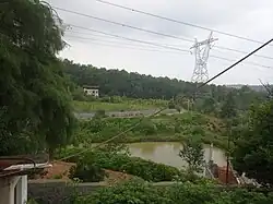
Eslamabad (Persian: اسلام آباد)[1] is a village in Sharq va Gharb-e Shirgah Rural District, North Savadkuh County, Mazandaran Province, Iran. At the 2016 census, its population was 138, in 41 households.[2] In 2011, it was registered as Eslamabad Industrial Zone, with a population of 83 people in 27 households.[3]
Eslamabad is located on the road between Shirgah and Marzikola. The industrial zone is located west of the village. Nearby villages are Kalij Kheyl in east and Gavan Kola, Babol Kenar in west.[4]
See also
References
- ^ Tappeh Sar can be found at GEOnet Names Server, at this link, by opening the Advanced Search box, entering "-3837454" in the "Unique Feature Id" form, and clicking on "Search Database".
- ^ Census of the Islamic Republic of Iran, 1395 (2016): Mazandaran Province. amar.org.ir (Report) (in Persian). The Statistical Center of Iran. Archived from the original (Excel) on 7 October 2021. Retrieved 19 December 2022.
- ^ "Census of the Islamic Republic of Iran, 1390 (2011)". Islamic Republic of Iran. Archived from the original (Excel) on 2016-10-06.
- ^ "Way: اسلام آباد (120041120)" (in Persian). OpenStreetMap. Retrieved 15 August 2025.
| Capital | |||||||||||||||||||||||
|---|---|---|---|---|---|---|---|---|---|---|---|---|---|---|---|---|---|---|---|---|---|---|---|
| Districts |
| ||||||||||||||||||||||
| References | "Rural Districts of Iran: Mazandaran-2021". amar.org. Statistical Center of Iran. Retrieved 6 July 2025. | ||||||||||||||||||||||