Shakujiimachi
Shakujiimachi
石神井町 | |
|---|---|
Neighborhood (町丁) | |
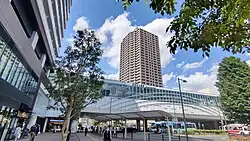 Shakujii-kōen Station's South Exit. | |
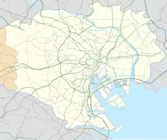 Shakujiimachi Location of Shakujiimachi within the Wards Area of Tokyo | |
| Coordinates: 35°44′38″N 139°36′21″E / 35.74389°N 139.60583°E | |
| Country | Japan |
| Region | Kantō |
| Metropolis | Tōkyō |
| Ward | Nerima |
| Area | |
• Total | 1.933 km2 (0.746 sq mi) |
| Population (March 1, 2007)[2] | |
• Total | 27,917 |
| • Density | 14,442.32/km2 (37,405.4/sq mi) |
| Time zone | UTC+9 (JST) |
| Zip code | 177-0041[3] |
| Area code | 03 |
Shakujiimachi (石神井町) is a neighborhood in Nerima Ward, Tokyo. The current administrative names go from Shakujiimachi 1st Street to 8th Street. The residential address system has been implemented.
Geography
Located slightly southwest of the center of Nerima Ward, it is home to Shakujii Park, Shakujii Pond, and Shakujii-kōen Station. The Shakujii River creates the southern border of the neighborhood. It is next to Shakujiidai and Higashi-Ōizumi to the west, Takanodai to the east, Shimo-Shakujii, Minami-Tanaka, and Kami-Shakujii across the Shakujii River to the south, and Miharadai and Yahara to the north.
References
- ^ "土地面積(町丁目別)" (in Japanese). 練馬区. 2014-10-01. Retrieved 2025-04-26.(CC-BY-4.0)
- ^ "世帯と人口(人口統計) - 町丁目別". 練馬区. 2025-07-08. Retrieved 2018-01-04.
- ^ "郵便番号簿 2024年度版" (PDF) (in Japanese). 日本郵便. Retrieved 2025-03-09.
| Areas |
| ||||||||
|---|---|---|---|---|---|---|---|---|---|
| Major Stations | |||||||||
| Education |
| ||||||||
| Landmarks |
| ||||||||
 | |||||||||