Saskatchewan Highway 135
.svg.png) Highway 135 | ||||
|---|---|---|---|---|
 | ||||
| Route information | ||||
| Maintained by Ministry of Highways and Infrastructure | ||||
| Length | 120.5 km[1] (74.9 mi) | |||
| Major junctions | ||||
| South end | ||||
| North end | Sandy Bay | |||
| Location | ||||
| Country | Canada | |||
| Province | Saskatchewan | |||
| Highway system | ||||
|
| ||||
| ||||
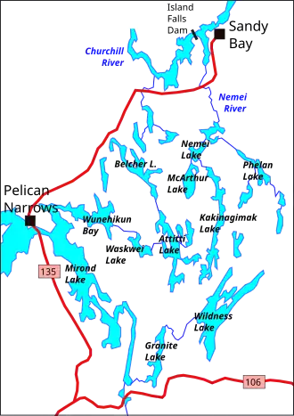
Highway 135 is a provincial highway in the Canadian province of Saskatchewan. It runs from Highway 106 near Jan Lake to Sandy Bay. It is about 121 kilometres (75 mi) long.[1]
Route description
Highway 135 connects with the Jan Lake Access Road near the Jan Lake Recreation Site, about 7 kilometres (4.3 mi) north of Highway 106. It runs north towards Mirond Lake where it crosses Opawikusehikan Narrows between Mirond and Pelican Lakes at Pelican Narrows. The highway passes through the community of Pelican Narrows within the Peter Ballantyne Cree Nation.[2] From there it runs north–east, crosses the Nemei River, then turns north to Sandy Bay on the Churchill River.
Major intersections
From south to north:
| Rural municipality | Location | km | mi | Destinations | Notes |
|---|---|---|---|---|---|
| Northern Saskatchewan Administration District | | 0.0 | 0.0 | Southern terminus | |
| | 0.8 | 0.50 | Access road into airport | ||
| Jan Lake Recreation Site | 7.1 | 4.4 | Jan Lake access road | ||
| Pelican Narrows 184B | 45.3– 45.5 | 28.1– 28.3 | Bridge over the Opawikusehikan Narrows | ||
| Pelican Narrows | 50.2 | 31.2 | Bear Street / McKinley Street | Hwy 135 makes a sharp right | |
| | 71.9 | 44.7 | Access road into airport | ||
| | 94.1 | 58.5 | Bridge over the Mukoman River | ||
| | 109.1 | 67.8 | Bridge over the Nemei River | ||
| Sandy Bay | 120.5 | 74.9 | Sandy Bay Avenue / Church Street | Northern terminus | |
| 1.000 mi = 1.609 km; 1.000 km = 0.621 mi | |||||
See also
References
- ^ a b "Highway 135 in Saskatchewan" (Map). Google Maps. Retrieved 17 February 2018.
- ^ "North - Pelican Narrows - Hwy 135". Tourism Saskatchewan. Government of Saskatchewan. Retrieved 27 July 2025.