Khad Koocha Tehsil
Khad Koocha Tehsil
Brahui: تحصیل کھڈ کوچہ Khad Kocha | |
|---|---|
 Khad Koocha Tehsil 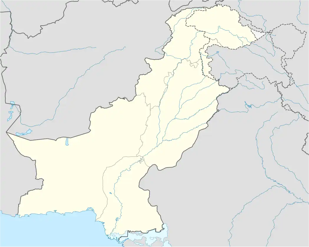 Khad Koocha Tehsil | |
| Coordinates: 29°40′10″N 66°46′50″E / 29.66944°N 66.78056°E | |
| Country | |
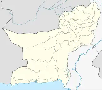
| Province | Balochistan |
| District | Mastung District |
| Tehsil | Khad Koocha |
| Area | |
• Tehsil of Mastung District | 640 km2 (250 sq mi) |
| Elevation | 1,081 m (3,547 ft) |
| Population (2023)[2] | |
• Tehsil of Mastung District | 46,316 |
| • Density | 72.37/km2 (187.4/sq mi) |
| • Rural | 46,316 (100%) |
| Literacy | |
| • Literacy rate |
|
| Time zone | UTC+5 (PST) |
| Main languages | 44,195 Brahui, 1,564 Pashto, 400 Balochi [4] |
Khad Koocha, also Khad Kocha and Khadkocha [a] is a (sub-tehsil) in Mastung District, situated in the northwestern part of Balochistan, Pakistan. According to the 2023 national census, it has a population of 46,316, residing across 66 rural settlements.[5] The town of Khad Koocha lies 18 kilometre south of Mastung. Agriculture is central to the local economy; however persistent water scarcity poses a major constraint on the productivity of cultivable land, particularly affecting the growth of temperate fruit orchards and winter vegetables.[6]
Earthquakes, floods, and droughts occur periodically in the district and are recognised as significant environmental risks.[7]
Geography
Covering spans an area of approximately 640 square kilometres and shares borders with Mangochar Tehsil of Kalat District to the south, Kirdgap Tehsil to the west, Mastung Tehsil to the northeast, and Dasht Tehsil to the east. The landscape is predominantly arid and mountainous, with elevations generally exceeding 1,000 metres (3,300 ft) and some peaks rising above 3,000 metres (9,800 ft). Seasonal streams traverse the rugged terrain, which is largely desert-like in character.
Climate
Mastung experiences a semi-arid climate, marked by long, hot, and dry summers, and short intensely cold winters that often accompanied by snowfall. Temperatures typically range from −2 °C (28 °F) to 34 °C (93 °F), with extremes rarely dipping below −6 °C (21 °F) or exceeding 37 °C (99 °F). Annual precipitation averages around 244 millimetres (9.6 in), with March being the wettest month.[8] Vegetation is sparse and xerophytic, consisting of thorny shrubs, hardy bushes, occasional trees, and various ephemeral plants.
Population
As recorded in the 2023 census, Khad Koocha Tehsil has a population of 46,316 residing in 5,954 households,[9] resulting in a moderate population density of approximately 72 persons per square kilometre.[2] The Tehsil faces notable development challenges, particularly in education. The literacy rate stands at 33.22%, with a gender disparities: 42.69% for males and just 22.55% for females, reflecting limited educational opportunities, especially for women and girls.[3]
Insurgency
Parts of Khad Koocha have been affected by the ongoing conflict between insurgent groups and state security forces in Balochistan.[10][11]
Armed groups, including the Balochistan Liberation Army and others, have called for increased political autonomy and greater control over local natural resources.[12] These security concerns are intertwined with persistent socio-economic difficulties, such as widespread poverty, inadequate access to healthcare and education, and underdeveloped infrastructure.[13][14]
References and notes
Explanatory notes
References
- ^ "Liari, Balochistan, Pakistan Climate Zone, Monthly Averages, Historical Weather Data". weatherandclimate.com. Weather and Climate. Retrieved 30 May 2025.
- ^ a b "Table 1: Area, Population by Sex, Sex Ratio, Population Density, Urban Population, Household Size and Annual Growth Rate, Balochistan" (PDF). pbs.gov.pk. Pakistan Bureau of Statistics, Census. 2023. Retrieved 6 August 2025.
- ^ a b "Table 12 - Population (10 years and above) by Literacy Rate, Enrolment and Out of School Population by Sex and Rural/Urban, Census 2023" (PDF). pbs.gov.pk. Pakistan Bureau of Statistics. Retrieved 6 August 2025.
- ^ "Table 11: Population by Mother Tongue, Gender, and Rural/Urban Residence (Census 2023)" (PDF). pbs.gov.pk. Pakistan Bureau of Statistics. Retrieved 6 August 2025.
- ^ "Balochistan Mouza Census 2020" (PDF). Pakistan Bureau of Statistics. 2020. p. 64. Retrieved 30 May 2025.
- ^ "District Economic Profile Mastung" (PDF). Small & Medium Enterprise Development Authority, Government of Pakistan. September 2022. p. 26. Retrieved 7 August 2025.
- ^ "District Profile Mastung". Scribd. Planning and Development Department of the Government of Balochistan / UNICEF. 18 July 2011. Retrieved 6 August 2025.
- ^ "Mastung Climate, Weather By Month, Average Temperature (Pakistan)". weatherspark.com. Cedar Lake Ventures. Retrieved 7 August 2025.
- ^ "Table 24: Housing Characteristics, Facilities of Toilet and Washroom Used by Households, Rural/Urban: Census 2023" (PDF). pbs.gov.pk. Pakistan Bureau of Statistics. 2023. Retrieved 6 August 2025.
- ^ Akhtar, Saadullah (1 October 2023). "'Mourning in every street': A Pakistani city, crushed by a suicide bomb". Al Jazeera. Retrieved 6 August 2025.
- ^ "Five militants killed, two apprehended in separate operations in Pakistan's northwest". arabnews.com. Vol. Arab News. 3 May 2025. Retrieved 6 August 2025.
- ^ Haider, Ejaz (27 August 2024). "Tired Cliches Won't Improve Balochistan". thefridaytimes.com. The Friday Times. Retrieved 6 August 2025.
- ^ Ahmadzai, Princess Mezyuna (6 April 2025). "Balochistan's Paradox: Rich in Resources, Poor in Development". moderndiplomacy.eu. Modern Diplomacy. Retrieved 6 August 2025.
- ^ Khan, Abdullah (10 March 2025). "Decades of change". Dawn.com. Dawn. Retrieved 7 June 2025.
| Kalat |
| ||||||||||||||
|---|---|---|---|---|---|---|---|---|---|---|---|---|---|---|---|
| Makran |
| ||||||||||||||
| Nasirabad |
| ||||||||||||||
| Quetta |
| ||||||||||||||
| Sibi |
| ||||||||||||||
| Zhob |
| ||||||||||||||
| Rakhshan |
| ||||||||||||||
| Loralai |
| ||||||||||||||
Sub-tehsils are listed in italics. | |||||||||||||||