Yockey, Indiana
Yockey, Indiana | |
|---|---|
 Yockey  Yockey | |
| Coordinates: 38°47′17″N 86°29′35″W / 38.78806°N 86.49306°W | |
| Country | United States |
| State | Indiana |
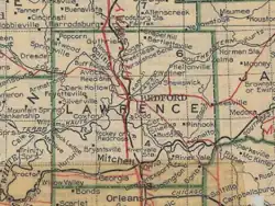
| County | Lawrence |
| Township | Marion |
| Elevation | 610 ft (190 m) |
| ZIP code | 47446 |
| FIPS code | 18-85904[2] |
| GNIS feature ID | 446395[1] |
Yockey, or Redcross or Juliet is a former unincorporated community in Marion Township, Lawrence County, Indiana.
Geography
Yockey was south of Bedford and north of Mitchell, on the Dixie Highway.[3]
History
Yockey has also been called Redcross[4] and Juliet.[5]
The community of Juliet was platted in 1850, in Section 11 of the township. The Louisville, New Albany & Chicago Railway was built through the area at that time, and due to Juliet being the terminus of the line for several months, the community "became quite a commercial point; goods were wagoned from there to Bedford, Bloomington, Greencastle and all towns on that line; stage lines were established away up in the direction of Chicago; but the completion of the railroad north ruined the town's prosperity, and it soon fell into decay" for a number of years.[5] The etymology of the name "Juliet" is unknown;[6] the post office operated from 1852 to 1869.[7]
The name became Yockey when the postal name changed on January 10, 1880.[8] The name Yockey honored Charles Yockey, editor of several county newspapers.[9] Yockey's population was 50 in 1890,[10] and was 57 in 1900.[4]
Under the name Redcross the post office operated from 1893 to 1913.[11] During this era, Redcross was the site of several lime kiln operations, which employed around 40 men in the area.[12] The railroad station in the community closed circa the 1930s, according to a 1935 newspaper article in the Mitchell Tribune.[13]
A central passage house was all that was left of the community by 1992.[14]
See also
References
- ^ a b U.S. Geological Survey Geographic Names Information System: Yockey, Indiana
- ^ "U.S. Census website". United States Census Bureau. Archived from the original on December 27, 1996. Retrieved January 31, 2008.
- ^ "Standard Map Series of Indiana" (PDF). Standard Map Company. 1919. Archived from the original (PDF) on August 19, 2025. Retrieved August 6, 2025.
- ^ a b Cram's Modern Atlas: The New Unrivaled. J. R. Gray & Company. 1900. p. 138.
- ^ a b History of Lawrence, Orange, and Washington Counties, Indiana: From the Earliest Time to the Present, Together with Interesting Biographical Sketches, Reminiscences, Notes, Etc. Goodspeed Brothers and Company. 1884. p. 175.
- ^ Gratzer, Florence Elise (1957). "A study of place names in Lawrence County, Indiana". Indiana State University. pp. 14–15. Archived from the original on May 25, 2025. Retrieved August 13, 2025.
- ^ Forte, Jim. "Post Offices: Indiana - Lawrence County". PostalHistory.org. Archived from the original on August 19, 2025. Retrieved August 13, 2025.
- ^ Guthrie, James Mitchell (1958). Thirty Three Years in the History of Lawrence County, Indiana, 1884-1917. p. 28.
- ^ Buher, Becky (2018). Railroads Big Part of Marion Township History. LawrenceCountyHistory.org. Archived from the original on December 13, 2018.
- ^ Cram, George Franklin (1891). Cram's Universal Atlas: Geographical, Astronomical and Historical, Containing a Complete Series of Maps of Modern Geography, Illustrated by Numerous Views and Charts; the Whole Supplemented with Valuable Statistics, Diagrams, and a Complete Gazetteer of the United States. G.F. Cram. p. 366.
- ^ Forte, Jim. "Post Offices: Indiana - Lawrence County". PostaHistory.org. Archived from the original on August 19, 2025. Retrieved August 13, 2025.
- ^ "Redcross". Bedford Democrat. Bedford, IN. April 27, 1897. p. 2.
The limekilns are furnishing work to many of our men. In all about 40 men are employed.
- ^ "Ghost Towns of Lawrence County". GeneologyTrails.com. Retrieved August 18, 2025.
- ^ "Lawrence County: Interim Report". Historic Landmarks Foundation of Indiana. 1992. Retrieved August 13, 2025.
Municipalities and communities of Lawrence County, Indiana, United States | ||
|---|---|---|
| Cities | 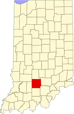 | |
| Town | ||
| Townships | ||
| CDPs | ||
| Other communities |
| |
| Former communities | ||