Whangara
Whangara
Whāngārā (Māori) | |
|---|---|
Town | |
| Coordinates: 38°34′14″S 178°13′45″E / 38.57056°S 178.22917°E | |
| Country | New Zealand |
| Region | Gisborne District |
| Ward | Tairāwhiti General Ward |
| Electorates | |
| Government | |
| • Territorial authority | Gisborne District Council |
| • Mayor of Gisborne | Rehette Stoltz[1] |
| • East Coast MP | Dana Kirkpatrick[2] |
| • Ikaroa-Rāwhiti MP | Cushla Tangaere-Manuel[3] |
| Area | |
• Total | 74.05 km2 (28.59 sq mi) |
| Population (2023 Census)[5] | |
• Total | 159 |
| • Density | 2.1/km2 (5.6/sq mi) |
| Time zone | UTC+12 (NZST) |
| • Summer (DST) | UTC+13 (NZDT) |
| Area code | 06 |
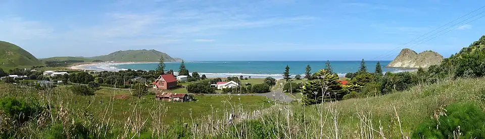
Whangara (Māori: Whāngārā [faː.ŋaː.ɾaː]) is a small community in the northeast of New Zealand's North Island,[6] located between Gisborne and Tolaga Bay, five kilometres southwest of Gable End Foreland and two kilometres east of State Highway 35.
The settlement features prominently in the early history of the Ngāti Porou iwi,[7] as the site where Tamatea, captain of the Tākitimu canoe settled on arriving in New Zealand. Canoe races were held at nearby Pikopiko-i-whiti, with the people watching from a hill called Puke-hapopo. The place name may be cognate with Fa'ara on Taha'a island in French Polynesia.[8]
Whangara was the location and setting for Witi Ihimaera's novel The Whale Rider and its film adaptation.[9]
Demographics
Whangara and its surrounds cover 74.05 km2 (28.59 sq mi).[4] It is part of the Wharekaka statistical area.[10]
| Year | Pop. | ±% p.a. |
|---|---|---|
| 2006 | 150 | — |
| 2013 | 135 | −1.49% |
| 2018 | 147 | +1.72% |
| 2023 | 159 | +1.58% |
| Source: [5][11] | ||
Whangara had a population of 159 in the 2023 New Zealand census, an increase of 12 people (8.2%) since the 2018 census, and an increase of 24 people (17.8%) since the 2013 census. There were 66 males and 93 females in 54 dwellings.[12] 1.9% of people identified as LGBTIQ+. The median age was 35.7 years (compared with 38.1 years nationally). There were 48 people (30.2%) aged under 15 years, 21 (13.2%) aged 15 to 29, 69 (43.4%) aged 30 to 64, and 24 (15.1%) aged 65 or older.[5]
People could identify as more than one ethnicity. The results were 47.2% European (Pākehā), 67.9% Māori, and 7.5% Pasifika. English was spoken by 94.3%, Māori by 34.0%, and other languages by 1.9%. No language could be spoken by 1.9% (e.g. too young to talk). The percentage of people born overseas was 7.5, compared with 28.8% nationally.[5]
Religious affiliations were 32.1% Christian, and 3.8% Māori religious beliefs. People who answered that they had no religion were 52.8%, and 11.3% of people did not answer the census question.[5]
Of those at least 15 years old, 27 (24.3%) people had a bachelor's or higher degree, 63 (56.8%) had a post-high school certificate or diploma, and 24 (21.6%) people exclusively held high school qualifications. The median income was $41,000, compared with $41,500 nationally. 12 people (10.8%) earned over $100,000 compared to 12.1% nationally. The employment status of those at least 15 was 51 (45.9%) full-time, 24 (21.6%) part-time, and 6 (5.4%) unemployed.[5]
Parks
Te Tapuwae o Rongokako Marine Reserve is a marine reserve covering 2,450 hectares of coastline south of Whangara, which is managed by the Department of Conservation.[13] The name means "The footprints of Rongokako," referring to an ancestor of Ngati Kahungunu who is said to have left a footprint at the site.[14][15]
Marae
The local Whāngārā Marae is a meeting place for the Ngāti Porou hapū of Ngāti Konohi.[6][16] It includes a wharenui, known as Whitirēia or Waho Te Rangi.[17]
In October 2020, the Government committed $49,626 from the Provincial Growth Fund to upgrade the marae, creating an estimated 3.4 jobs.[18]
Education
Whangara School is a Year 1–8 co-educational state primary school[19] with a roll of 95 students as of July 2025.[20][21][22] Whangara Native School opened in 1902, and was rebuilt in 1945 after a fire.[23]
References
- ^ "Councillor contact details". Gisborne District Council. Retrieved 28 July 2025.
- ^ "East Coast - Official Result". Electoral Commission. Retrieved 1 June 2025.
- ^ "Ikaroa-Rāwhiti – Official Result". New Zealand Electoral Commission. Retrieved 28 July 2025.
- ^ a b "Stats NZ Geographic Data Service". Statistical Area 1 2023 (generalised). Retrieved 17 August 2025.
- ^ a b c d e f "Totals by topic for individuals, (RC, TALB, UR, SA3, SA2, Ward, Health), 2013, 2018, and 2023 Censuses". Stats NZ – Tatauranga Aotearoa – Aotearoa Data Explorer. 7015499. Retrieved 3 October 2024.
- ^ a b Soutar, Monty (30 March 2015). "Story: East Coast places". Te Ara - the Encyclopedia of New Zealand. Retrieved 5 April 2019.
- ^ Chapter 1: Mohena Kohere's antecedents, in The Story of a Maori Chief, by Reweti T. Kohere. Reed Publishing (NZ) Ltd, 1949. Part of the New Zealand Texts Collection, New Zealand Electronic Text Centre, Victoria University. Retrieved 27 November 2009.
- ^ Best, Elsdon (1917). "Some place names of islands of the Society Group". Journal of the Polynesian Society. 26 (3): 112.
- ^ Sheila Johnston. Riding the crest of the whale, telegraph.co.uk, 5 July 2003. Retrieved 27 November 2009.
- ^ "Geographic Boundary Viewer". Stats NZ. Statistical Area 1 – 2023 and Statistical Area 2 – 2023.
- ^ "Statistical area 1 dataset for 2018 Census". Statistics New Zealand. March 2020. 7015499.
- ^ "Totals by topic for dwellings, (RC, TALB, UR, SA3, SA2, Ward, Health), 2013, 2018, and 2023 Censuses". Stats NZ – Tatauranga Aotearoa – Aotearoa Data Explorer. Retrieved 3 October 2024.
- ^ "DOC Places to Go - East Coast". doc.govt.nz. Department of Conservation.
- ^ Mitchell, J. H. (2014). Takitimu: A History of Ngati Kahungunu. Libro International. p. 55. ISBN 978-1-877514-72-2.
- ^ Royal, Te Ahukaramū Charles (2007). "Stories of people and land". Te Ara: The Encyclopedia of New Zealand. Retrieved 31 December 2023.
- ^ "Te Kāhui Māngai directory". tkm.govt.nz. Te Puni Kōkiri.
- ^ "Māori Maps". maorimaps.com. Te Potiki National Trust.
- ^ "Marae Announcements" (Excel). growregions.govt.nz. Provincial Growth Fund. 9 October 2020.
- ^ "Official School Website". whangara.school.nz.
- ^ "New Zealand Schools Directory". New Zealand Ministry of Education. Retrieved 1 July 2025.
- ^ "Ministry of Education School Profile". educationcounts.govt.nz. Ministry of Education.
- ^ "Education Review Office Report". ero.govt.nz. Education Review Office.
- ^ "History". Whangara School. Retrieved 17 August 2025.