Whataupoko
Whataupoko | |
|---|---|
 Tairāwhiti Museum | |
| Coordinates: 38°39′S 178°02′E / 38.650°S 178.033°E | |
| Country | New Zealand |
| City | Gisborne |
| Local authority | Gisborne District Council |
| Electoral ward | Tairāwhiti General Ward |
| Area | |
| • Land | 379 ha (937 acres) |
| Population (June 2024)[2] | |
• Total | 4,310 |
| Mangapapa | ||
| Te Hapara |
|
|
| Gisborne Central | Kaiti |
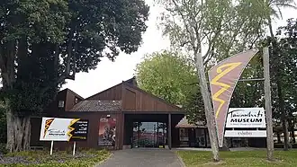
Whataupoko is the central residential suburb of the city of Gisborne in New Zealand. It is northeast of the Gisborne Central business district, across the Taruheru River, and north of the suburb of Kaiti, across the Waimata River. The suburb of Mangapapa is north-west of Whataupoko. Significant facilities are the headquarters of the Gisborne District Council and the regional museum, Tairāwhiti Museum,[3][4] both located near the southern point of Whataupoko at the confluence of the two rivers.
History and naming
The name Whataupoko derives from the Māori terms whata, meaning an elevated stage or platform, and upoko, meaning head. In about 1740, two warriors came to the area to try to drive the local people out. The two attackers were captured and beheaded, and their heads (upoko) were hung from a rail on an elevated platform (whata), and so the name came about.[5]
Demographics
Whataupoko covers 3.79 km2 (1.46 sq mi)[1] and had an estimated population of 4,310 as of June 2024,[2] with a population density of 1,137 people per km2.
| Year | Pop. | ±% p.a. |
|---|---|---|
| 2006 | 3,708 | — |
| 2013 | 3,705 | −0.01% |
| 2018 | 3,930 | +1.19% |
| 2023 | 4,020 | +0.45% |
| The 2006 population is for a smaller area of 3.65 km2. Source: [6][7] | ||
Whataupoko had a population of 4,020 in the 2023 New Zealand census, an increase of 90 people (2.3%) since the 2018 census, and an increase of 315 people (8.5%) since the 2013 census. There were 1,917 males, 2,091 females, and 12 people of other genders in 1,539 dwellings.[8] 2.5% of people identified as LGBTIQ+. The median age was 42.7 years (compared with 38.1 years nationally). There were 762 people (19.0%) aged under 15 years, 636 (15.8%) aged 15 to 29, 1,788 (44.5%) aged 30 to 64, and 834 (20.7%) aged 65 or older.[6]
People could identify as more than one ethnicity. The results were 79.8% European (Pākehā); 29.6% Māori; 2.1% Pasifika; 6.0% Asian; 0.7% Middle Eastern, Latin American and African New Zealanders (MELAA); and 3.3% other, which includes people giving their ethnicity as "New Zealander". English was spoken by 97.6%, Māori by 7.5%, Samoan by 0.1%, and other languages by 8.6%. No language could be spoken by 1.8% (e.g. too young to talk). New Zealand Sign Language was known by 0.2%. The percentage of people born overseas was 18.8, compared with 28.8% nationally.[6]
Religious affiliations were 31.3% Christian, 0.6% Hindu, 0.3% Islam, 1.2% Māori religious beliefs, 0.5% Buddhist, 0.4% New Age, and 1.8% other religions. People who answered that they had no religion were 57.2%, and 6.9% of people did not answer the census question.[6]
Of those at least 15 years old, 864 (26.5%) people had a bachelor's or higher degree, 1,773 (54.4%) had a post-high school certificate or diploma, and 630 (19.3%) people exclusively held high school qualifications. The median income was $44,300, compared with $41,500 nationally. 402 people (12.3%) earned over $100,000 compared to 12.1% nationally. The employment status of those at least 15 was 1,701 (52.2%) full-time, 531 (16.3%) part-time, and 51 (1.6%) unemployed.[6]
| Name | Area (km2) |
Population | Density (per km2) |
Dwellings | Median age | Median income |
|---|---|---|---|---|---|---|
| Whataupoko East | 2.69 | 1,914 | 712 | 711 | 42.0 years | $48,500[9] |
| Whataupoko West | 1.10 | 2,106 | 1,915 | 825 | 43.7 years | $41,200[10] |
| New Zealand | 38.1 years | $41,500 |
Parks
The Whataupoko Reserve includes a dog walking area, and walking and mountain biking tracks.[11]
Waiteata Park has a picnic area and playground.[11]
There are also several local parks in the area which allow dogs on leashes: Ballance Street Reserve, Fox Street Reserve, Grant Road Reserve, Hall Street Reserve and Sheehan Street Reserve.[11]
Education
Gisborne Central School is a Year 1–6 co-educational state school[12] with a roll of 357 as of July 2025.[13][14][15] The school was founded in 1872.[16] Secondary classes were held at Central School from 1888 until Gisborne High School opened in the early 20th century.[17]
References
- ^ a b "Stats NZ Geographic Data Service". Statistical Area 3 2023 (generalised). Retrieved 11 August 2025.
- ^ a b "Aotearoa Data Explorer". Statistics New Zealand. Retrieved 26 October 2024.
- ^ "Tairāwhiti Museum". Tairāwhiti Museum.
- ^ "Tairāwhiti Museum". Kōtuia. Te Papa Tongarewa.
- ^ Salmond, Anne; Phillips, Caroline. Te Awaroa: Restoring 1000 Rivers: Research Report 2: Waimata River (PDF). University of Auckland. pp. 4–5. Retrieved 24 August 2023.
- ^ a b c d e "Totals by topic for individuals, (RC, TALB, UR, SA3, SA2, Ward, Health), 2013, 2018, and 2023 Censuses". Stats NZ – Tatauranga Aotearoa – Aotearoa Data Explorer. Whataupoko (53950). Retrieved 3 October 2024.
- ^ "Statistical area 1 dataset for 2018 Census". Statistics New Zealand. March 2020. Whataupoko East (206600) and Whataupoko West (206700).
- ^ "Totals by topic for dwellings, (RC, TALB, UR, SA3, SA2, Ward, Health), 2013, 2018, and 2023 Censuses". Stats NZ – Tatauranga Aotearoa – Aotearoa Data Explorer. Retrieved 3 October 2024.
- ^ "Totals by topic for individuals, (RC, TALB, UR, SA3, SA2, Ward, Health), 2013, 2018, and 2023 Censuses". Stats NZ - Tatauranga Aotearoa - Aotearoa Data Explorer. Whataupoko East. Retrieved 3 October 2024.
- ^ "Totals by topic for individuals, (RC, TALB, UR, SA3, SA2, Ward, Health), 2013, 2018, and 2023 Censuses". Stats NZ - Tatauranga Aotearoa - Aotearoa Data Explorer. Whataupoko West. Retrieved 3 October 2024.
- ^ a b c "Gisborne Parks and Reserves". gdc.govt.nz. Gisborne District Council.
- ^ "Official School Website". gisbornecentral.school.nz.
- ^ "New Zealand Schools Directory". New Zealand Ministry of Education. Retrieved 1 July 2025.
- ^ "Ministry of Education School Profile". educationcounts.govt.nz. Ministry of Education.
- ^ "Education Review Office Report". ero.govt.nz. Education Review Office.
- ^ Marshall, Jack (19 December 2020). "Bell a-ringing at Central School". Gisborne Herald.
- ^ MacKay, Joseph Angus (1949). "Gisborne High School". Historic Poverty Bay and the East Coast, N.I., N.Z.