Vasiľov
Vasiľov | |
|---|---|
 Flag | |
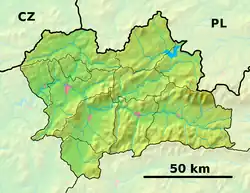 Vasiľov Location of Vasiľov in the Žilina Region  Vasiľov Location of Vasiľov in Slovakia | |
| Coordinates: 49°21′N 19°23′E / 49.35°N 19.38°E | |
| Country | |
| Region | |
| District | Námestovo District |
| First mentioned | 1554 |
| Area | |
• Total | 9.14 km2 (3.53 sq mi) |
| Elevation | 652 m (2,139 ft) |
| Population (2021)[3] | |
• Total | 827 |
| Time zone | UTC+1 (CET) |
| • Summer (DST) | UTC+2 (CEST) |
| Postal code | 295 1[2] |
| Area code | +421 43[2] |
| Car plate | NO |
| Website | www |
Vasiľov (Hungarian: Vasziló) is a village and municipality in Námestovo District in the Žilina Region of northern Slovakia.
History
In historical records the village was first mentioned in 1554.
World war II
In September 1939 citizens of Vasiľov witnessed crossing of German soldiers heading to Poland.
4. April front crossed the village. Early in the morning soviets started bombardment around the village. Later that day soviets soldiers arrived.
Geography
The municipality lies at an altitude of 428 metres and covers an area of 9.147 km2. It has a population of about 757 people.
References
- ^ "Hustota obyvateľstva - obce [om7014rr_ukaz: Rozloha (Štvorcový meter)]". www.statistics.sk (in Slovak). Statistical Office of the Slovak Republic. 2022-03-31. Retrieved 2022-03-31.
- ^ a b c "Základná charakteristika". www.statistics.sk (in Slovak). Statistical Office of the Slovak Republic. 2015-04-17. Retrieved 2022-03-31.
- ^ "Počet obyvateľov podľa pohlavia - obce (ročne)". www.statistics.sk (in Slovak). Statistical Office of the Slovak Republic. 2022-03-31. Retrieved 2022-03-31.