Oravská Lesná
Oravská Lesná | |
|---|---|
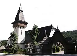 Church of Saint Anna in the village | |
 Flag  Coat of arms | |
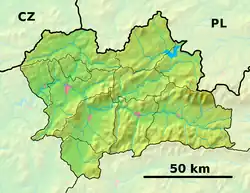 Oravská Lesná Location of Oravská Lesná in the Žilina Region  Oravská Lesná Location of Oravská Lesná in Slovakia | |
| Coordinates: 49°22′N 19°11′E / 49.37°N 19.18°E | |
| Country | |
| Region | |
| District | Námestovo District |
| First mentioned | 1732 |
| Area | |
• Total | 65.63 km2 (25.34 sq mi) |
| Elevation | 858 m (2,815 ft) |
| Population (2021)[3] | |
• Total | 3,431 |
| Time zone | UTC+1 (CET) |
| • Summer (DST) | UTC+2 (CEST) |
| Postal code | 295 7[2] |
| Area code | +421 43[2] |
| Car plate | NO |
| Website | oravskalesna |
Oravská Lesná (1920-1927 Erdútka, 1927-1945 Erdótka Hungarian: Erdőtka) is a village and municipality in Námestovo District in the Žilina Region of northern Slovakia.
History
In historical records the village was first mentioned in 1731.
Geography
The municipality lies at an altitude of 934 metres and covers an area of 65.628 km². It has a population of about 3133 people. It borders Gmina Ujsoły, poland and zákameneklin to the north, lomná to the east, zázrivá to the south, and nová bystrica to the west,
Climate
It's the coldest inhabited location in Slovakia.[4]
References
- ^ "Hustota obyvateľstva - obce [om7014rr_ukaz: Rozloha (Štvorcový meter)]". www.statistics.sk (in Slovak). Statistical Office of the Slovak Republic. 2022-03-31. Retrieved 2022-03-31.
- ^ a b c "Základná charakteristika". www.statistics.sk (in Slovak). Statistical Office of the Slovak Republic. 2015-04-17. Retrieved 2022-03-31.
- ^ "Počet obyvateľov podľa pohlavia - obce (ročne)". www.statistics.sk (in Slovak). Statistical Office of the Slovak Republic. 2022-03-31. Retrieved 2022-03-31.
- ^ "Slovakia's TOP Sights in Žilina Region". Archived from the original on 2014-05-22. Retrieved 2014-05-21.