Typhoon Podul
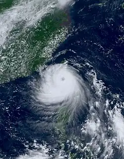 Podul at its peak intensity while approaching Taitung County on 13 August | |
| Meteorological history | |
|---|---|
| Formed | 6 August 2025 |
| Dissipated | 15 August 2025 |
| Typhoon | |
| 10-minute sustained (JMA) | |
| Highest winds | 150 km/h (90 mph) |
| Lowest pressure | 960 hPa (mbar); 28.35 inHg |
| Category 2-equivalent typhoon | |
| 1-minute sustained (SSHWS/JTWC) | |
| Highest winds | 175 km/h (110 mph) |
| Lowest pressure | 966 hPa (mbar); 28.53 inHg |
| Overall effects | |
| Fatalities | 2 |
| Injuries | 149 |
| Missing | 1 |
| Damage | >$14.3 million (2025 USD) |
| Areas affected | Northern Mariana Islands, Philippines, Ryukyu Islands, Taiwan, East China, South China, Hong Kong, Macau, Vietnam |
| IBTrACS | |
Part of the 2025 Pacific typhoon season | |
Typhoon Podul (pronounced [pɔ.dul]), known in the Philippines as Typhoon Gorio, was a relatively small but moderately strong tropical cyclone that impacted Taiwan and South China in mid-August 2025. The eleventh named storm and fourth typhoon of the annual typhoon season, Podul originated from an area of convection approximately 230 nautical miles (430 km) northeast of Saipan in the Northern Mariana Islands. Guided west-northwestwards by a subtropical ridge, the system gradually organised in an environment of warm sea surface temperatures, high ocean heat content, and low to moderate wind shear. On 8 August, it intensified into a tropical storm and was given the name Podul from the Japan Meteorological Agency (JMA). Although strong northeasterly vertical wind shear and entrainment of dry air initially disrupted its core, Podul steadily consolidated, with deep convection and tighter convective banding around its low-level circulation centre (LLCC). The JMA upgraded the system to a typhoon on 9 August, followed by the Joint Typhoon Warning Center (JTWC) on 12 August. Podul reached its peak intensity on 13 August as a Category 2-equivalent typhoon before making landfall in Taimali, Taitung County, Taiwan. After weakening over the Central Mountain Range, it crossed the Taiwan Strait as a severe tropical storm and made a second landfall in Zhangpu, Fujian Province, China.
In Taiwan, where the storm made its first landfall, over 8,000 people were evacuated. Heavy rainfall triggered flooding in several areas, while strong winds left more than 292,000 households without power. One death, 112 injuries, and a missing person were reported. Transport was heavily affected, with dozens of flights cancelled or diverted at Taipei Taoyuan International Airport, where a UPS Airlines Boeing 747 sustained engine damage during landing in strong winds. In China's Guangdong province, authorities relocated around 75,000 residents from flood-prone areas as the storm brought heavy rainfall in Guangzhou.
Meteorological history
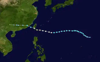
Tropical storm (39–73 mph, 63–118 km/h)
Category 1 (74–95 mph, 119–153 km/h)
Category 2 (96–110 mph, 154–177 km/h)
Category 3 (111–129 mph, 178–208 km/h)
Category 4 (130–156 mph, 209–251 km/h)
Category 5 (≥157 mph, ≥252 km/h)
Unknown
On 6 August, the JTWC began monitoring an area of disorganised convection located approximately 230 nautical miles (430 km) northeast of Saipan. Later that same day, the JMA also initiated tracking of the developing system, classifying it as a tropical depression based on improved low-level circulation and persistent convection. By 7 August, the JTWC assessed that environmental conditions were conducive for further development, including warm sea surface temperatures and low to moderate vertical wind shear. As a result, the agency issued a Tropical Cyclone Formation Alert (TCFA), upgrading the system's development potential to high and noting that the system was likely to undergo tropical cyclogenesis in the near term.[1] At 00:00 UTC, the JTWC upgraded the system to a tropical depression and designated it 16W.[2] During the early hours of 8 August, the system intensified further, prompting the JMA to upgrade it to a tropical storm and assign it the international name Podul.[3] Initially, Podul's LLCC remained partially exposed due to moderate to strong northeasterly vertical wind shear. However, over the subsequent 24 hours, the system gradually became more organised, with convection consolidating near the centre and improved outflow aloft.[4]
At 01:45 UTC on 9 August, the JMA upgraded Podul to a typhoon as it tracked westwards across the western North Pacific. This intensification occurred despite the presence of increasing vertical wind shear, as the storm's structure became more vertically aligned and sustained deep convection persisted near the centre. Later that day, at 23:20 PHT (15:20 UTC), Podul entered the Philippine Area of Responsibility (PAR), at which point the Philippine Atmospheric, Geophysical and Astronomical Services Administration (PAGASA) assigned it the local name Gorio.[5] At 11:45 PHT (03:45 UTC), the JMA downgraded Podul back into a severe tropical storm; however, the agency later upgraded back to a typhoon. At 22:00 UTC on 12 August, the JTWC upgraded the storm to a minimal typhoon, as deep convection had begun to consolidate around the northern sector of the cyclone's circulation. However, a narrow intrusion of dry air continued to penetrate the central core, slightly disrupting the system's organisation.[6] On 13 August, JTWC upgraded Podul to a Category 2-equivalent typhoon as animated radar imagery revealed a well-defined eye, surrounded by a robust burst of deep convection.[7] At around 13:00 TST (05:00 UTC), Podul made landfall over Taimali in Taitung County, Taiwan.[8] Later, the rugged terrain of the southern portion of the Central Mountain Range had made Podul weakened significantly after landfall.[9] It then reemerged through the Taiwan Strait at around 16:00 CST (08:00 UTC). The storm continued to deteriorate before it made a second landfall over Zhangpu County, Zhangzhou, Fujian Province in China on 14 August.[10] Afterwards, the JTWC made its final warning as it moved inland, while the JMA continues to track Podul as it weakened into tropical storm. The JMA further downgraded it to a tropical depression until ceasing all advisories on 15 August as it dissipated over Hunan Province.
Preparations
Northern Mariana Islands
Although no direct impact was expected in the islands, a tropical storm watch was issued over Agrihan, Pagan, and Alamagan, citing that tropical storm force conditions with maximum sustained winds of 39 mph (34 kn) or more are possible. However, it was later lifted as Podul continued to move westwards.[11]
Philippines
While a significant impact was not expected in the country, a Tropical Cyclone Wind Signal No. 1 warning was issued in Batanes on 12 August, as the storm was expected to bring minor impacts in the area.[12] On 13 August, the PAGASA later upgraded the storm signal to Signal No. 2 in Itbayat, while Signal No. 1 was hoisted for the remainder part of Batanes.[13] Flights going to Basco and Itbayat were cancelled as Podul neared the province.[14] The PAGASA later lifted all storm signals as the storm moved away from the country.
Taiwan
Some maritime transport routes operated by the Maritime Port Bureau (MPB) and the Kinmen County Harbour Bureau were suspended on 12 and 13 August, as a precautionary measure ahead of the arrival of Podul. The suspensions affected ferry and shipping services in vulnerable coastal areas, particularly those in the projected path of the storm. Taiwan-based airlines, including Mandarin Airlines and Uni Air, announced the cancellation of all domestic flights scheduled for 13 August. Daily Air also reported the cancellation of several domestic flights due to anticipated severe weather conditions. In addition, numerous international flights operated by Taiwan’s China Airlines and Tigerair Taiwan were suspended on the same day. EVA Air confirmed that all flights to and from Kaohsiung International Airport were either cancelled or rescheduled due to safety concerns. However, operations at Taipei Songshan Airport and Taoyuan International Airport remained partially active, with some flights also affected by delays and cancellations.[15][16]
In response to the approaching typhoon, the Central Weather Administration issued both land warning for multiple counties and municipalities, including the counties of Changhua, Hualien, Nantou, Taitung and Pingtung, and Kaohsiung. The warning indicated that these areas were expected to be directly impacted by the eye of Typhoon Podul prior to its landfall.[17][18] A sea warning was also issued, citing the possibility of waves reaching up to 5 m (16 ft) along the west coast south of Changhua, as well as the eastern coasts of Hualien and Taitung.[19] As a precautionary measure, more than 5,500 residents were evacuated from high-risk areas, particularly in southern and eastern Taiwan. Local authorities coordinated emergency shelters and implemented safety protocols to accommodate displaced individuals.[20][21] In total, 252 domestic flights and 129 international flights were cancelled due to the adverse weather conditions brought by Podul.[22] Additionally, local governments across various regions announced class and work suspensions on 13 August as part of their preparedness measures, urging citizens to stay indoors and avoid unnecessary travel during the typhoon’s passage.[23]
China
In Fujian, some flights going to and from Xiamen Gaoqi International Airport and high-speed rail services were cancelled on 13 and 14 August ahead of the preparation of Podul.[24] In Chaozhou, Guangdong, operations at all schools, daycare centres, and educational training institutions were temporarily halted to ensure safety from Podul. Maritime activities were also suspended as the typhoon approached the province.[25]
Elsewhere
In Hong Kong, at 08:40 HKT (01:40 UTC) on 13 August, the Hong Kong Observatory (HKO) issued the Standby Signal No. 1 as the storm neared the territory.[26] The warning signal was lifted at 12:20 HKT (04:20 UTC) the following day.[27] Fifteen flights between Hong Kong and Taiwan were cancelled, in addition to one operated by HK Express to Ishigaki, in the Ryukyu Islands, and another by Greater Bay Airlines to Quanzhou in Fujian.[28]
Impact and aftermath
Taiwan
A total of 112 people were injured as Podul brushed through the country. Heavy rainfall from the typhoon caused flooding in several areas, including roads, nearby houses, and Kenting National Park in Hengchun.[29] A man in Kaohsiung died after falling while repairing a storm-damaged roof.[30] More than 292,000 households lost power nationwide.[29] A 28-year-old man was reported missing after being swept away by waves while fishing with a friend in Budai, Chiayi County. It was later found out that the man had died.[31] At Taipei Taoyuan International Airport, 64 passenger and cargo flights were cancelled, and 26 flights were diverted to nearby airports as of 15:19 TST (07:19 UTC).[32] A Boeing 747, operated by UPS Airlines, suffered an engine damage while attempting to land during strong gusts and wind shear at Taoyuan International Airport. The north runway was temporarily closed for repairs and debris removal but reopened for dual-runway operations at 23:38 TST (15:38 UTC).[33]
Taiwan’s Republic of China Air Force deployed an aircraft to transport stranded travellers from Kinmen to Kaohsiung.[34]
Hong Kong
Although Podul indirectly impacted the territory, the HKO issued a black rainstorm warning at 07:50 HKT (23:50 UTC) on 14 August,[35][36] the fifth instance of the year, following the red rainstorm signal in the early hours, citing that severe rainstorm had affected Lantau Island, the central business district, and several nearby districts, until it was downgraded to the red rainstorm signal at 11:10 HKT (03:10 UTC).[37] The red signal in the early morning led to the announcement of the suspension of morning and full-day classes and members the public were urged to remain on high alert and take necessary precautions.[38][39] The Airport Authority said rainfall at the intensity of 300 millimetres per hour (12 in/h) was recorded on the island of Chek Lap Kok.[40] Landing of aircraft has since been assigned only to the north and south runways (07L/25R and 07R/25L) and not to the centre runway because of damages to ILS equipment. On 13 August, the HKO issued Standby Signal No. 1 at 08:40 HKT (00:40 UTC) before halting it the next day at 12:40 HKT (04:40 UTC).[41]
Macau
In Macau, heavy rainfall associated with the outer bands of the storm led to localised flooding on 14 August in the afternoon, prompting the issuance of the black rainstorm signal,[42] the closure of several schools, and the temporary shutdown of some roads and low-lying areas in Taipa. According to the Meteorological and Geophysical Bureau (SMG), the storm indirectly brought up to 110 mm (4.3 inches) of rain to certain parts of the territory over a short period, significantly disrupting daily activities and public transport services.[43]
Vietnam
The remnants of Podul, alongside a low-pressure area in the South China Sea, also brought heavy rain in Northern Vietnam from 14 to 15 August.[44]
China
In Guangdong, 75,000 individuals were evacuated from low-lying areas as Podul brought 622.6 mm (24.5 inches) of rainfall in Guangzhou.[45]
See also
Other similar typhoons:
- Typhoon Betty (1975)
- Typhoon Andy (1982)
- Typhoon Pabuk (2007)
- Typhoon Fanapi (2010)
- Typhoon Tembin (2012)
- Typhoon Nepartak (2016) - a much stronger storm that struck Taiwan and later devastated East China
- Typhoon Nesat (2017) - a strong typhoon that struck Taiwan at a similar intensity and also had the same Philippine name
- Typhoon Haikui (2023)
- Typhoon Koinu (2023)
- Typhoon Gaemi (2024) - destructive typhoon that took a nearly equal path
- Typhoon Meranti (2016) - a violent typhoon that struck the Batanes in the Philippines and Northern Taiwan. Similar movement of Podul.
References
- ^ JTWC, Joint Typhoon Warning Center (7 August 2025). "Tropical Cyclone Formation Alert (Invest 98W)". Retrieved 7 August 2025.
- ^ Tropical Depression 16W (Sixteen) Warning No. 1 (Report). United States Joint Typhoon Warning Center. 7 August 2025. Retrieved 7 August 2025.
- ^ "LPA develops into Tropical Depression Fabian, but already moving away". Rappler. 8 August 2025. Retrieved 8 August 2025.
- ^ Prognostic Reasoning for Tropical Storm 16W (Podul) Warning No. 8 (Report). United States Joint Typhoon Warning Center. 9 August 2025. Retrieved 9 August 2025.
- ^ "Severe Tropical Storm Podul enters PAR as Gorio". GMA News. 10 August 2025. Retrieved 11 August 2025.
- ^ "Prognostic Reasoning for Typhoon 16W (Podul) Warning No. 20". Joint Typhoon Warning Center. United States Navy. Retrieved 12 August 2025.
- ^ "Prognostic Reasoning for Typhoon 16W (Podul) Warning No. 24". Joint Typhoon Warning Center. United States Navy. Retrieved 13 August 2025.
- ^ "Typhoon Podul makes landfall in Taiwan's Taitung County". Focus Taiwan. 13 August 2025. Retrieved 13 August 2025.
- ^ "Prognostic Reasoning for Typhoon 16W (Podul) Warning No. 26". Joint Typhoon Warning Center. United States Navy. Retrieved 13 August 2025.
- ^ "Storm makes landfall in China after raking Taiwan as typhoon". The Business Times. 14 August 2025. Retrieved 14 August 2025.
- ^ "Tropical storm Podul bypasses Guam, threatens northern islands". The Guam Daily Post. 8 August 2025. Retrieved 11 August 2025.
- ^ "Batanes under Signal No. 1 as Typhoon Gorio nears, threatens northern islands". Philstar Global. 12 August 2025. Retrieved 12 August 2025.
- ^ "PAGASA: Itbayat, Batanes still under Signal No. 2 as Gorio slightly intensifies". GMA News. 13 August 2025. Retrieved 13 August 2025.
- ^ "Gorio grounds flights, disrupts supplies in Batanes". Inquirer. 13 August 2025. Retrieved 13 August 2025.
- ^ "Taiwan announces service, activity suspensions due to Typhoon Podul". Focus Taiwan. 12 August 2025. Retrieved 12 August 2025.
- ^ "Typhoon Podul slams into southern Taiwan, hundreds of flights cancelled". GMA News. 13 August 2025. Retrieved 14 August 2025.
- ^ "Taiwan issues land warning as Typhoon Podul nears". China Daily. 12 August 2025. Retrieved 12 August 2025.
- ^ "Taiwan Starts Large-Scale Evacuations as Typhoon Podul Nears". CTN News. 13 August 2025. Retrieved 13 August 2025.
- ^ "Sea warning issued for Typhoon Podul". Taipei Times. 13 August 2025. Retrieved 15 August 2025.
- ^ "Hundreds seek shelter as Typhoon Podul nears Taiwan". ABS-CBN. 13 August 2025. Retrieved 13 August 2025.
- ^ "Typhoon Podul intensifies as it nears Taiwan". Channel News Asia. 13 August 2025. Retrieved 13 August 2025.
- ^ "Typhoon "Podul" hits Taitung, Taiwan, cancels hundreds of flights and forces mass evacuations". The Nation. 12 August 2025. Retrieved 13 August 2025.
- ^ "Taiwan announces work and school closures as Typhoon Podul arrives". Taiwan News. 12 August 2025. Retrieved 13 August 2025.
- ^ "Typhoon Podul disrupts flights and train schedules in Guangdong". Info Guangdong. 12 August 2025. Retrieved 13 August 2025.
- ^ "Mainland braces for Podul's 2nd landfall". Info Guangdong. 13 August 2025. Retrieved 14 August 2025.
- ^ "Hong Kong issues T1 warning as Severe Typhoon Podul edges closer". South China Morning Post. Retrieved 13 August 2025.
- ^ "HKO Tropical Cyclone Warning Bulletin". Retrieved 14 August 2025.
- ^ "Typhoon Podul: airlines axe or delay 15 Hong Kong–Taiwan flights". South China Morning Post. 13 August 2025. Retrieved 13 August 2025.
- ^ a b "1 missing, over 100 injured, 8,000 evacuated as Typhoon Podul batters Taiwan". Focus Taiwan. Retrieved 13 August 2025.
- ^ "楊柳颱風過境 高雄七旬翁修樓頂漏水墜樓亡". United Daily News (in Chinese). 13 August 2025. Retrieved 14 August 2025.
- ^ "Weather tracker: Typhoon Podul pounds southern Taiwan". Taipei Times. 15 August 2025. Retrieved 16 August 2025.
- ^ "People injured, missing as storm hits". Taipei Times. 14 August 2025. Retrieved 14 August 2025.
- ^ "UPS cargo plane damaged during landing at Taoyuan Airport". Taiwan News. 14 August 2025. Retrieved 14 August 2025.
- ^ "Ferries, aircraft assist stranded passengers after typhoon disruption". Focus Taiwan. Retrieved 15 August 2025.
- ^ "Tropical Cyclone Podul: Schools cancelled as black rain signal hoisted, residents urged to stay indoors". Hong Kong Free Press. Retrieved 14 August 2025.
- ^ "Heavy rainfall causes flooding in Central and Western Districts of HK Island".
- ^ "Storm Podul: Hong Kong lowers black rainstorm signal to red, warns of flooding". South China Morning Post. Retrieved 14 August 2025.
- ^ "Storm Podul: Hong Kong issues black rainstorm warning, cancels classes". South China Morning Post. 14 August 2025. Retrieved 14 August 2025.
- ^ "Heavy rainfall causes flooding in Central and Western Districts of HK Island".
- ^ "Press Releases, Media Centre - Hong Kong International Airport". www.hongkongairport.com. Retrieved 19 August 2025.
- ^ "Tropical Cyclone Warning Signals (August 2025)". Hong Kong Observatory. 13 August 2025. Retrieved 15 August 2025.
- ^ "TDM".
- ^ "China braces for heavy rains as Tropical Storm Podul makes landfall". ABC News. 14 August 2025. Retrieved 14 August 2025.
- ^ Áp thấp trên Biển Đông kết hợp hoàn lưu bão Podul trút mưa xối xả
- ^ "Tropical storm Podul disrupts travel and schools in southern China". Channel News Asia. 14 August 2025. Retrieved 14 August 2025.
External links
Tropical cyclones of the 2025 Pacific typhoon season | ||
|---|---|---|
 | ||
| ||