Tolokiwa Island
 | |
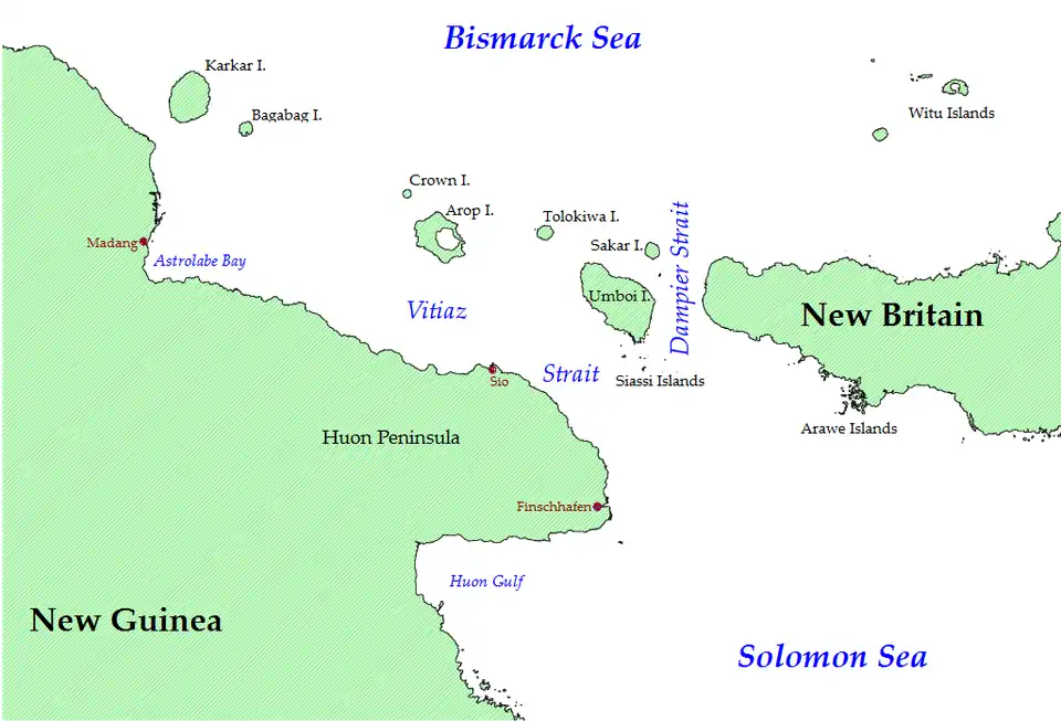 Tolokiwa Island is to the west of New Britain | |
 Tolokiwa Island  Tolokiwa Island | |
| Geography | |
|---|---|
| Location | Bismarck Sea |
| Coordinates | 5°19′S 147°36′E / 5.317°S 147.600°E |
| Archipelago | Bismark Archipelago |
| Administration | |
| Province | Morobe Province |
| LLG | Siassi Rural LLG |
Tolokiwa Island, also known as Lottin Island, is an island in the Bismarck Sea, situated between Long Island and Umboi. The island is volcanic in origin and part of the Bismarck Archipelago. It is in the Lokep Ward of the Siassi Rural LLG local government area of the Morobe Province of Papua New Guinea (PNG).[1] Although the island has suffered no recent volcanic eruptions, it is in an area that suffers from frequent earthquakes.[2]
History
The earliest known sighting of the island by outsiders was by William Dampier, an English explorer, privateer, navigator, and naturalist. He sailed past Long Island and Tolikawa Island in 1700 and drew profiles in his log book.[3]
Description
Tolokiwa Island is situated 75 km north of the New Guinea mainland. The island has a diameter of 7 km and an area of 46 km2. Its highest point in the Sulany peak at 1372 metres. The island was built up by a series of volcanic eruptions during the Pleistocene epoch.[4] The well-vegetated[5] island is an important natural site for birds,[6] and is home to several species of resident birds (which it unusually shares with nearby islands). However, these may not be birds indigenous to the island as it is believed that wildlife would have been wiped out by a volcanic eruption on Long Island in the mid 17th-century.[3][7] Tolokiwa is also home to a subspecies of Turdus Poliocephalus, the Tasman Sea island thrush.[8]
The island sustained damage during the 13 March 1888 eruption of nearby Ritter Island, which caused a tsunami to hit Tolokiwa and other islands as well as the north coast of New Guinea.[9]
References
- ^ "Village Coordinates Lookup". OCHA. Retrieved 15 July 2025.
- ^ "Latest quakes in or near Lottin Island, Morobe Province, Papua New Guinea". Volcano Discovery. Retrieved 15 July 2025.
- ^ a b Blong, Russell (2021). ""It's Volcanic Ash!" a Response that Began a 50-Year Odyssey". Geographical Bulletin. 62 (2). Retrieved 15 July 2025.
- ^ "Tolokiwa Island - John Seach". Volcano Live. Retrieved 15 July 2025.
- ^ Thornton, Ian W. B. (2001). "Colonization of an Island Volcano, Long Island, Papua New Guinea, and an Emergent Island, Motmot, in Its Caldera Lake. I. General Introduction". Journal of Biogeography. 28 (11/12): 1299–1310. doi:10.1046/j.1365-2699.2001.00642.x. JSTOR 827420.
- ^ Collins, Michael D.; Simberloff, Daniel; Connor, Edward F. (2011). "Binary matrices and checkerboard distributions of birds in the Bismarck Archipelago". Journal of Biogeography. 38 (12): 2373–2383. Bibcode:2011JBiog..38.2373C. doi:10.1111/j.1365-2699.2011.02506.x. JSTOR 41310592.
- ^ Diamond, Jared M. (1974). "Colonization of Exploded Volcanic Islands by Birds: The Supertramp Strategy". Science. 184 (4138): 803–806. Bibcode:1974Sci...184..803D. doi:10.1126/science.184.4138.803. JSTOR 1738665. PMID 17783475. S2CID 4058437.
- ^ Diamond, Jared M. (March 1989). "A New Subspecies of the Island Thrush Turdus poliocephalus from Tolokiwa Island in the Bismarck Archipelago". Emu. 89 (1): 58–60. Bibcode:1989EmuAO..89...58D. doi:10.1071/MU9890058.
- ^ Ward, Steven N.; Day, Simon (September 2003). "Ritter Island Volcano-lateral collapse and the tsunami of 1888". Geophysical Journal International. 154 (3): 891–902. Bibcode:2003GeoJI.154..891W. doi:10.1046/j.1365-246X.2003.02016.x.
Islands of Papua New Guinea | |
|---|---|
| Bismarck Archipelago | |
| Louisiade Archipelago | |
| North Solomon Islands | |