Ritter Island
| Ritter Island | |
|---|---|
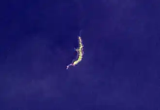 Ritter Island in 2004 | |
| Highest point | |
| Elevation | 140 m (460 ft) |
| Prominence | 140 m (460 ft) |
| Coordinates | 5°31′S 148°07′E / 5.517°S 148.117°E |
| Geography | |
| Location | Papua New Guinea |
| Geology | |
| Mountain type | Stratovolcano |
| Last eruption | May 2007 |
Ritter Island is a small, uninhabited, crescent-shaped volcanic island 100 kilometres (62 mi) north-east of New Guinea, in the Bismarck Sea, situated between Umboi Island and Sakar Island in the Morobe Province of Papua New Guinea (PNG) and close to New Britain island.[1]
It is one of many active volcanoes in PNG, which result from a subduction of the Solomon Sea plate beneath the South Bismarck Plate along the New Britain Trench. There were several recorded eruptions of this basaltic-andesitic stratovolcano in 1699 and 1793, prior to a spectacular lateral collapse which took place in 1888. Before that event, it was a circular conical island about 780 metres (2,560 ft) high.[1][2]
History
The earliest known sighting of the island by outsiders was by William Dampier, an English explorer, privateer, navigator, and naturalist. He reported that "we heard a dreadful noise like thunder, and saw a flame of fire after it, the most terrifying that ever I saw". The island is believed to have been named after the German geographer, Carl Ritter, when the area formed part of German New Guinea.[3]
1888 eruption
At about 5:30 am local time on 13 March 1888 a large portion of the island, containing perhaps 5 km3 (1.2 cu mi) of material slid into the sea during a relatively minor, possibly VEI 2,[4] phreatic eruption. Eyewitnesses at Finschhafen, 100 km (62 mi) to the south, heard explosions and observed an almost imperceptible ash fall.[5] Tsunamis 12–15 metres (40–50 ft) high were generated by the collapse and devastated nearby islands and the adjacent New Guinea coast killing around 3,000 people.[6]
The collapse left a 140-metre (460 ft) high, 1,900-metre (6,200 ft) long crescent-shaped island with a steep west-facing escarpment. At least two small eruptions have occurred offshore since 1888, one in 1972 and another in 1974, which have resulted in the construction of a small submarine edifice within the collapse scar.[5]
See also
References
- ^ a b "1888 Ritter Island Tsunami". Scholarly Community Encyclopedia. Retrieved 15 July 2025.
- ^ "Ritter Island". Global Volcanism Program. Smithsonian Institution. Retrieved 2009-04-28.
- ^ "Perished in Style – Ritter Island, PNG". Volcano Hotspot. Retrieved 15 July 2025.
- ^ "Ritter Island: Eruptive History". Global Volcanism Program. Smithsonian Institution. Retrieved 2009-04-28.
- ^ a b Ward, S.N. & Day, S. (2003). "Ritter Island Volcano—lateral collapse and the tsunami of 1888" (PDF). Geophysical Journal International. 154 (3): 891–902. Bibcode:2003GeoJI.154..891W. doi:10.1046/j.1365-246X.2003.02016.x. Retrieved 2007-06-11.
- ^ Ritter Island at Volcano World
Islands of Papua New Guinea | |
|---|---|
| Bismarck Archipelago | |
| Louisiade Archipelago | |
| North Solomon Islands | |