The John Paul II Bridge (Polish: Most Jana Pawła II), also known as the Third Millennium Bridge (Polish: Most Trzeciego Tysiąclecia), is a cable-stayedroad bridge located in Gdańsk, Poland, opened on 9 November 2001 and linking the Northern Port of Gdańsk with the Tricity Ring Road (S7). It crosses the Dead Vistula.
Characteristics
Opened on 9 November 2001, the bridge has four lanes, two per each direction of traffic. It has a width of 20.31 metres (66.6 ft), a height of 99.89 metres (327.7 ft), and its main span measures 230 metres (750 ft) in length. The cost of constructing it totalled 150 million zł.[1]
Construction
The bridge began being constructed in August 1999. Scaffolding was not used, and the bridge's components were transported by barges down the Vistula.[2] During construction, it was initially called the Third Millennium Bridge. When it was named after John Paul II, the media began referring to it also as the John Paul II Third Millennium Bridge (Polish: Most Trzeciego Tysiąclecia im. Jana Pawła II).[3]
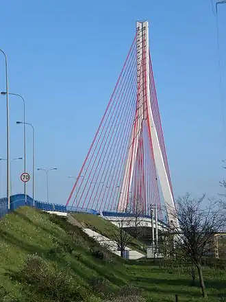
 The bridge from a distance, 2010
 Driving onto the bridge
 View from the top of the pylons
 The bridge in winter