Savareh, Ardabil
Savareh
Persian: سواره | |
|---|---|
Village | |
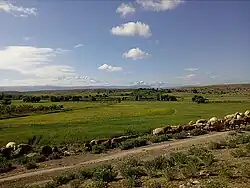 The village of Savareh | |
 Savareh | |
| Coordinates: 38°31′19″N 47°42′19″E / 38.52194°N 47.70528°E[1] | |
| Country | Iran |
| Province | Ardabil |
| County | Meshgin Shahr |
| District | Central |
| Rural District | Meshgin-e Sharqi |
| Population (2016)[2] | |
• Total | 209 |
| Time zone | UTC+3:30 (IRST) |
Savareh (Persian: سواره)[a] is a village in Meshgin-e Sharqi Rural District[4] of the Central District in Meshgin Shahr County, Ardabil province, Iran.
Demographics
Population
At the time of the 2006 National Census, the village's population was 153 in 38 households.[5] The following census in 2011 counted 155 people in 41 households.[6] The 2016 census measured the population of the village as 209 people in 67 households.[2]
Overview
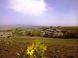
15 km towards Ardabil, after the village of Korbulaq, it is located on the left side and in the tourist area of Kapez. The people of this village are mostly engaged in animal husbandry and agriculture, and most of the orchards of this Rosna are apples, peaches and nectarines. This village has tourist attractions. Among them are Kepez, Samad Darsi, Delik Dash and Suyogh Bolaq, and many ancient artifacts from the ancient period can be seen in abundance in this village.
The people of this village are composed of 3 clans named Ivatli, Mughanlu and Chachikli, and the elders and elders of these clans are: Ali Ebadi, Mughanli: Hasan Rahor and Chachikli: Havar Nemati.
The water rights of this village rotate between 12 people and its water source is supplied from two springs that flow in the north and south sides.
The amenities of this village include piped drinking water, gas, electricity and telephone.
Among the famous ancient Atha of this village is Shaitan Tepe. Tepe Shaitan Tepe Si belongs to the Sassanid period and this work was registered as one of the national works of Iran on January 12, 2006, with registration number 20330.
See also
Notes
References
- ^ OpenStreetMap contributors (23 May 2025). "Suvara, دهستان مشگین شرقی, بخش مرکزی [Meshgin-e Sharqi Rural District, Central District], Meshkinshahr County, Iran" (Map). OpenStreetMap (in Persian). Retrieved 23 May 2025.
- ^ a b سرشماري عمومي نفوس و مسكن 1395 : استان اردبیل [General Population and Housing Census 2016: Ardabil Province]. مرکز آمار ایران [Statistical Centre of Iran] (in Persian). Archived from the original (Excel) on 22 March 2019. Retrieved 19 June 2025.
- ^ Savareh can be found at GEOnet Names Server, at this link, by opening the Advanced Search box, entering "-3829115" in the "Unique Feature Id" form, and clicking on "Search Database".
- ^ Mousavi, Mir-Hossein (9 August 1987) [تاریخ تصویب (Approval date) 1366/05/18 (Iranian Jalali calendar)]. ایجاد و تشکیل 10 دهستان شامل روستاها، مزارع و مکانهای در شهرستان مشکین شهر تابع استان آذربایجان شرقی [Creation and formation of 10 rural districts including villages, farms and places in Meshgin Shahr County under East Azerbaijan province]. لام تا کام [Lam ta Kam] (in Persian). وزارت کشور [Ministry of the Interior]. هیات وزیران [Council of Ministers]. شناسه [ID] C18B26BE-7AB6-4FA9-AB16-B3D821034797. شماره دوره [Course number] 66, شماره جلد [Volume number] 11. Archived from the original on 19 June 2025. Retrieved 19 June 2025.
- ^ سرشماري عمومي نفوس و مسكن 1385 : استان اردبیل [General Population and Housing Census 2006: Ardabil Province]. مرکز آمار ایران [Statistical Centre of Iran] (in Persian). Archived from the original (Excel) on 20 September 2011. Retrieved 19 June 2025.
- ^ سرشماري عمومي نفوس و مسكن 1390 : استان اردبیل [General Population and Housing Census 2011: Ardabil Province]. Iran Data Portal—Syracuse University (in Persian). مرکز آمار ایران [Statistical Centre of Iran]. Archived from the original (Excel) on 15 January 2023. Retrieved 19 June 2025.
| Capital |  | ||||||||||||||||||||||
|---|---|---|---|---|---|---|---|---|---|---|---|---|---|---|---|---|---|---|---|---|---|---|---|
| Counties and cities |
| ||||||||||||||||||||||
| Landmarks |
| ||||||||||||||||||||||
| Places | |||||||||||||||||||||||