Rakaia Gorge Bridge
Rakaia Gorge Bridge | |
|---|---|
 Rakaia Gorge Bridge as viewed from the riverbed to the East, 2025 | |
| Coordinates | 43°31′3.71″S 171°39′26.27″E / 43.5176972°S 171.6572972°E |
| Carries | 1 lane of roadway |
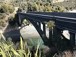
| Crosses | Rakaia River |
| Locale | Canterbury, Windwhistle |
| Maintained by | New Zealand Transport Agency |
| Characteristics | |
| Design | Bollman Truss Bridge |
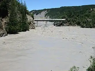
The Rakaia Gorge Bridge is a bridge located on the Rakaia River in inland Canterbury in New Zealand's South Island. The bridge connects the Selwyn and Ashburton districts and carries State Highway 77 and the Inland Scenic Route. It is one of only two bridges crossing the Rakaia River, and the oldest, with the other being the Rakaia Bridge, carrying State Highway 1.
Construction was conducted between 1880 and 1882 by contractors W. H. Barnes. It is a category 1 historic place as defined by Heritage New Zealand.
Description
The Rakaia Gorge Bridge has a design quite similar to the "Bollman Truss"[1][2] bridge design seen in only one other remaining bridge anywhere in the world, the Bollman Truss Railroad Bridge. The design was patented in 1852 by Wendel Bollman, a United States railway engineer. The design involves a series of non-symmetrical trussed beams of iron being jointed to vertical members by hinged pins to facilitate construction, and more than 100 examples were constructed on railways such as the Baltimore and Ohio Railroad among others, all of which are now demolished.[3][2] Regarding the design, Bollman wrote “This bridge has the advantage of great strength and perfect security, with very little weight of metal". The bridge design enjoyed great success for a number of years before it was superseded by more economic and effective bridge designs. The bridge differs from the works of Bollman in that the diagonal ties are anchored at each end by concrete-filled sockets that are tunnelled into the rock outcrops on which the abutments are placed.
For many years, those in the New Zealand engineering scene believed the bridge to be a Bollman Truss, with the School of Engineering in Christchurch even teaching prospective civil engineers that the local bridge followed this design.[4]
The bridge also closely resembles the "Fink truss" bridge design, also used commonly throughout US railroad development.[1] These similarities may be attributed to the experience of Carruthers, a key engineer involved in the design, in the United State throughout the 1860s, during which time both the Bollman and Fink truss designs were commonplace.
The Rakaia Gorge Bridge spans 57 metres and features a timber deck and handrail on top of its iron girders and truss. The bridge is also thought to be one of the earliest wrought iron bridges in New Zealand, and one of the few 19th century components of the New Zealand state highway network.[5]
History
Ferry and bridge prospects
The Rakaia Gorge was recognised as an important route for drovers and early settlers during the early 1850's, when it formed a part of the main route taken to inland Canterbury by settlers originating from Christchurch. In 1851, the Phillips Family constructed an accommodation house and began a ferry service across the mouth of the gorge soon after that. John Bryan was an early ferryman who went on to construct a larger accommodation house at the site with his wife, which burnt down in 1874.[4]
The route was first considered for bridge construction in 1863, during planning for the main south railway line from Christchurch. Some suggested that instead of crossing the Rakaia River near the mouth where it is at its longest, the line deviate inland and cross the gorge. The main reasoning for this was concerns regarding shifting shingle, an unstable river bed, and notably the length of bridge needed[4]. Eventually, in 1864, a commission determined the gorge route should be abandoned, and the route cross the Rakaia River further downstream near the mouth, eventuating in the longest bridge in the southern hemisphere at the time of construction.
By 1873, pressure was mounting from local land owners on the need for a bridge over the gorge to facilitate faster travel over the river. The provincial engineer initially examined two sites, one being at Goat Island (its present day location), and one further upstream. There was also intense debate over what the bridge should carry, whether it be just pedestrians and stock, drays, locomotive traffic or even rail. The discussion process was even further confused by the two tiered system of government at the time, provincial, and central.
The Secretary of Public Works finally contacted the Canterbury Provincial Engineer George Thornton in 1875 requesting an initial design. The early design was expected to cost £15,000 and consisted of two iron bridges and a cutting over Goat Island. The first bridge would have a span of 67 metres, and the second 47 metres, with both capable of carrying light automotive traffic.[4] One of Thornton's assistants, W. G. Bull, regarding the feasibility of a bridge at this location, remarked "[The bridge would be] blown clean away from the towers before six months were over" and that "taking all circumstances into consideration we may dismiss from our mind the practicality of bridging the river at this point."

On the 27th of July 1876, Engineer-In-Chief of the Public Works Department (PWD), John Carruthers, reported to the Minister that while he agreed with the site, he did not think a suspension bridge was appropriate. He instead suggested a pier mid-river for the first bridge and removal of the second bridge, favouring an embankment to cut off the flood channel entirely. Thornton was staunchly opposed to this design, and on the 24th of October wrote to the Secretary of Public Works stating that Carruthers' proposal would result in flooding of the site where the accommodation house lay, and the cost of the bridge would be increased by the pier, which would be liable to damage from flooding.
Design and construction
At the time of planning and construction, the New Zealand Government had recently been centralised and the PWD restructured, resulting in several high-profile engineers being involved in the design and construction. Involved engineers included Thornton, Carruthers, William Newsham Blair, and Peter Seton Hay. Designers and engineers had to contend with an elevation of 17 metres from the usual water level, up to 6000 cubic metres per second in flood water, and wind speeds regularly reaching above 160km/h.[4]
The final plans for the bridge were registered in July 1876. The final design is referenced on the plans as being designed by a "Wood", although records return no biographical details of Mr. Wood, nor his precise role in the project. Carruthers' signature is also on the plans, however it is unknown whether this is purely a "stamp of approval" or evidence of core design involvement.
In 1877 the PWD concluded debate on the bridge and decided to move forward with construction of a single lane road traffic bridge with the opportunity to carry rail if needed.[5] The opportunity for carrying rail was included due to prospects at the time regarding the South Island Central Trunk Railway, which would run along the foothills of the Southern Alps. This railway never eventuated, and therefore the bridge never ended up carrying rail of any sort.[1]
The Public Works Department had called for tenders twice already before finally finding a willing contractor, and in the end the bridge was constructed by W. H. Barnes of Oamaru for a payment of £3,619.[5] The iron for the project was produced in England, and delivered to Coalgate by September 1879. Construction took much longer than expected, primarily due to two large slips in 1881 that needed to be cleared by the contractors before work could proceed, and as a result Barnes were penalised by £306, resulting in a final payment for completing the project of £3,313. Construction was finally completed in 1882, however road traffic could only begin using the bridge in 1884 when the flood channel was bridged with a timber bridge[1].
As early as 1890, wind resistance of the structures was a concern and further work was conducted by Peter Seton Hay to design additional wind bracing for both bridges. This came as a result of damage from wind gusts in late 1889. No major repair work has been conducted since, with minor upgrades between 2005 and 2011, and regular maintenance from the New Zealand Transport Agency.
Flood channel bridge
In 1884, a wooden bridge was constructed across the flood channel, between Goat Island and the southern bank of the gorge. This bridge had a main span of 36 metres and three smaller side spans, constructed by the contractor Daulby. This wooden bridge was replaced by the present reinforced concrete bridge in 1945, following concerns from the War Cabinet.
In 1942, when the Japanese military forces were moving south in the Pacific during World War II, there were concerns regarding a military attack on New Zealand. The existing wooden bridge could not carry a Matilda I tank as the bridge had an estimated 5 ton axle load. Urgency was given by the War Cabinet to design and construct a reinforced concrete bridge over the flood channel to replace the wooden bridge, and as a temporary solution, large concrete culverts were laid which were promptly swept away in flood.[4] The width of this bridge was doubled to 7 metres, as opposed to a narrower one lane bridge.
Social and economic significance
The bridge initially served the local farming communities, who were experiencing substantial growth in the tail end of the 19th century. The bridge across the Rakaia Gorge further boosted economic activity stimulated by the construction of the Rakaia to Methven branch railway, and assisted in the development of several main roads throughout the 1880s by the Mount Hutt Road Board.
On top of serving farming interests, the bridge is also vital for those coming to Mount Hutt for recreation purposes. As early as 1880, people from across the South Island were coming to Mount Hutt, with the primary intent of scaling Mount Hutt and adjacent mountains. In 1969, plans for a Mount Hutt ski field began, and it became operational within a few years. In 1976 the Rakaia to Methven branch railway closed, hitting the economy hard, however the addition of the new ski field supported Methven and continues to be a strong pillar of its economy today.[6] Today, the bridge is primarily used for tourism traffic, either those coming from Christchurch to Mount Hutt, or international tourists following the Inland Scenic Route.
The bridge was registered as a historic place in September 1985 under the Historic Places Act, and is currently categorised as a Category 1 Historic Place by Heritage New Zealand.[3]
References
- ^ a b c d Astwood, Karen (10 June 2013). "Rakaia Gorge Bridge, Windwhistle" (PDF). IPENZ Engineering Heritage Register Report.
- ^ a b Griggs Jr., Frank (February 2015). "Bollman Truss at Harper's Ferry". Structure. Retrieved 16 July 2025.
- ^ a b "Old Rakaia Gorge Bridge". New Zealand Heritage List/Rārangi Kōrero. Heritage New Zealand. Retrieved 19 August 2025.
- ^ a b c d e f Jones, G M (30 November 1994). "Rakaia Gorge Bridge - The Truss that Isn't" (PDF). Proceedings of The First Australasian Conference on Engineering Heritage: 51–60.
- ^ a b c "Rakaia Gorge Bridge | Engineering New Zealand". www.engineeringnz.org. Retrieved 16 July 2025.
- ^ "Council Planned Projects | Methven Community Strategic Plan". Our place - Tōtātou Wāhi. Retrieved 27 July 2025.