Pioneer, Singapore
Pioneer | |
|---|---|
| Other transcription(s) | |
| • Chinese | 先驱 |
| • Pinyin | Xiānqū |
| • Malay | Pioneer |
| • Tamil | பயனியர் |
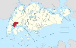 Location of Pioneer in Singapore | |
.svg.png) Pioneer | |
| Coordinates: 01°20′14″N 103°41′49″E / 1.33722°N 103.69694°E | |
| Country | |
| Region | West |
| Government | |
| • Mayors | South West CDC
|
| • Members of Parliament | West Coast GRC |
| Area | |
• Total | 12.1 km2 (4.7 sq mi) |
| Population (2024)[2] | |
• Total | 50 |
| • Density | 4.1/km2 (11/sq mi) |
| Ethnic groups | |
Pioneer is a planning area located in the West Region of Singapore, named after Pioneer Road. The area is bounded by Jurong West to the north, Boon Lay to the east, Tuas to the west, the Western Water Catchment to the northwest and Selat Jurong to the south. It contains several major industrial estates including Joo Koon, Benoi and Gul Circle, which form part of the larger Jurong Industrial Estate. Pioneer today comprises five subzones: Benoi Sector, Gul Basin, Gul Circle, Joo Koon and the Pioneer Sector itself.
Etymology
The area was formerly known as Jalan Besi.[3] During the development of Jurong Industrial Estate, JTC Corporation renamed the Malay-named roads in the area into English, particularly those near Jalan Buroh. Pioneer Road was previously Jalan Besi (Malay: Metal Road), Pioneer Road North was Jalan Bandaran (Malay: Town Road) and Pioneer Circus was Bulatan Besi (Malay: Metal Circus or Metal Circle).
References
- ^ "GE2020 results: PAP's Patrick Tay wins Pioneer SMC with 61.98% of votes over PSP and independent candidate". AsiaOne. Retrieved 11 July 2020.
- ^ "Statistics Singapore - Geographic Distribution - Latest Data". Retrieved January 10, 2025.
- ^ "Old map of Jurong".
.jpg)