Nižná, Tvrdošín District
Nižná | |
|---|---|
.jpg) | |
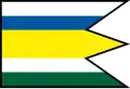 Flag 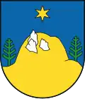 Coat of arms | |
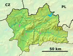 Nižná Location of Nižná in the Žilina Region  Nižná Location of Nižná in Slovakia | |
| Coordinates: 49°18′37″N 19°31′48″E / 49.31028°N 19.53000°E | |
| Country | |
| Region | |
| District | Tvrdošín District |
| First mentioned | 1420 |
| Area | |
• Total | 27.78 km2 (10.73 sq mi) |
| Elevation | 584 m (1,916 ft) |
| Population (2021)[3] | |
• Total | 3,931 |
| Time zone | UTC+1 (CET) |
| • Summer (DST) | UTC+2 (CEST) |
| Postal code | 274 3[2] |
| Area code | +421 43[2] |
| Car plate | TS |
| Website | www |
Nižná (Hungarian: Nizsna) is a village and municipality in Tvrdošín District in the Žilina Region of northern Slovakia.
History
In historical records the village was first mentioned in 1420 as Nissne Wes.
Geography
The municipality lies at an altitude of 573 metres and covers an area of 27.779 km². It has a population of about 4,140 people.
Twin towns — sister cities
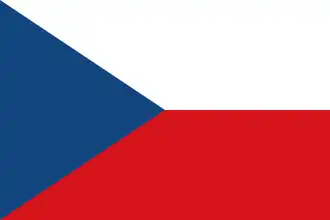 Horní Suchá, Czech Republic
 Mszana Dolna, Poland
References
- ^ "Hustota obyvateľstva - obce [om7014rr_ukaz: Rozloha (Štvorcový meter)]". www.statistics.sk (in Slovak). Statistical Office of the Slovak Republic. 2022-03-31. Retrieved 2022-03-31.
- ^ a b c "Základná charakteristika". www.statistics.sk (in Slovak). Statistical Office of the Slovak Republic. 2015-04-17. Retrieved 2022-03-31.
- ^ "Počet obyvateľov podľa pohlavia - obce (ročne)". www.statistics.sk (in Slovak). Statistical Office of the Slovak Republic. 2022-03-31. Retrieved 2022-03-31.
- ^ "Úvodní strana". nizna.sk (in Slovak). Nižná. Retrieved 2019-09-09.