Podbiel
Podbiel | |
|---|---|
 | |
 Flag  Coat of arms | |
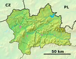 Podbiel Location of Podbiel in the Žilina Region  Podbiel Location of Podbiel in Slovakia | |
| Coordinates: 49°19′N 19°29′E / 49.32°N 19.48°E | |
| Country | |
| Region | |
| District | Tvrdošín District |
| First mentioned | 1564 |
| Area | |
• Total | 19.29 km2 (7.45 sq mi) |
| Elevation | 559 m (1,834 ft) |
| Population (2021)[3] | |
• Total | 1,330 |
| Time zone | UTC+1 (CET) |
| • Summer (DST) | UTC+2 (CEST) |
| Postal code | 274 2[2] |
| Area code | +421 43[2] |
| Car plate | TS |
| Website | www |
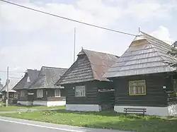
Podbiel (Hungarian: Podbjel) is a village and municipality in Tvrdošín District in the Žilina Region of northern Slovakia. It contains a beautiful set of traditional wooden cottages, which have been declared a folk architecture preservation area.
History
In historical records, the village was first mentioned in 1564.
Geography
The municipality lies at an altitude of 555 metres and covers an area of 19.293 km2. It has a population of about 1255 people.
References
- ^ "Hustota obyvateľstva - obce [om7014rr_ukaz: Rozloha (Štvorcový meter)]". www.statistics.sk (in Slovak). Statistical Office of the Slovak Republic. 2022-03-31. Retrieved 2022-03-31.
- ^ a b c "Základná charakteristika". www.statistics.sk (in Slovak). Statistical Office of the Slovak Republic. 2015-04-17. Retrieved 2022-03-31.
- ^ "Počet obyvateľov podľa pohlavia - obce (ročne)". www.statistics.sk (in Slovak). Statistical Office of the Slovak Republic. 2022-03-31. Retrieved 2022-03-31.