McHenry County, North Dakota
McHenry County | |
|---|---|
 The McHenry County Courthouse in Towner | |
 Location within the U.S. state of North Dakota | |
 North Dakota's location within the U.S. | |
| Coordinates: 48°14′02″N 100°38′00″W / 48.233842°N 100.633267°W | |
| Country | |
| State | |
| Founded | January 4, 1873 (created) October 15, 1884 (organized) |
| Seat | Towner |
| Largest city | Velva |
| Area | |
• Total | 1,911.519 sq mi (4,950.81 km2) |
| • Land | 1,873.942 sq mi (4,853.49 km2) |
| • Water | 37.577 sq mi (97.32 km2) 1.97% |
| Population (2020) | |
• Total | 5,345 |
• Estimate (2024) | 5,135 |
| • Density | 2.740/sq mi (1.058/km2) |
| Time zone | UTC−6 (Central) |
| • Summer (DST) | UTC−5 (CDT) |
| Area code | 701 |
| Congressional district | At-large |
| Website | mchenrycountynd.com |
McHenry County is a county in the U.S. state of North Dakota. As of the 2020 census, the population was 5,345.[1] The county seat is Towner, and largest city is Velva.[2]
McHenry County is part of the Minot, ND Micropolitan Statistical Area.
History
The Dakota Territory legislature created the county on January 4, 1873, with territory annexed from Bottineau County. It was named for James McHenry, an early settler of Vermillion (in present South Dakota). The county government was not organized at that time, nor was the county attached to another county for administrative and judicial purposes. The county organization was effected on October 15, 1884. The county boundaries were altered in 1885, 1887, 1891, and in 1892. It has retained its present boundaries since 1892.[3][4]
When the county was organized in 1884, Villard was named as county seat. In 1885 this designation was moved to Scriptown. In 1886 the designation was again moved, to Towner, which has remained the seat to the present time (the two former sites are now ghost towns).[5]
Geography
The Souris River loops through the county before turning north to its eventual discharge into Lake Winnipeg. The Wintering River drains the southern part of the county. The county terrain consists of rolling hills, partly devoted to agriculture (including limited use of center pivot irrigation).[6] The terrain slopes to the north and east, with its highest point on the west boundary line near the southwest corner, at 2,156 ft (657 m) ASL.[7]
According to the United States Census Bureau, the county has a total area of 1,911.519 square miles (4,950.81 km2), of which 1,873.942 square miles (4,853.49 km2) is land and 37.577 square miles (97.32 km2) (1.97%) is water.[8] It is the 8th largest county in North Dakota by total area.[9]
Major highways
Adjacent counties
- Bottineau County - north
- Pierce County - east
- Sheridan County - southeast
- McLean County - southwest
- Ward County - west
- Renville County - northwest
National protected areas
Lakes
Source:[6]
- Bromley Lake
- Buffalo Lodge Lake
- Connia Slough
- Erickson Lake
- Heringen Lake
- Horseshoe Lake (part)
- Lake George
- Lake Hester
- Lauinger Lake
- Martin Lake
- North Lake
- Potters Lake
- Round Lake
- Smoky Lake (part)
- Stevens Slough
- Stink Lake
Demographics
| Census | Pop. | Note | %± |
|---|---|---|---|
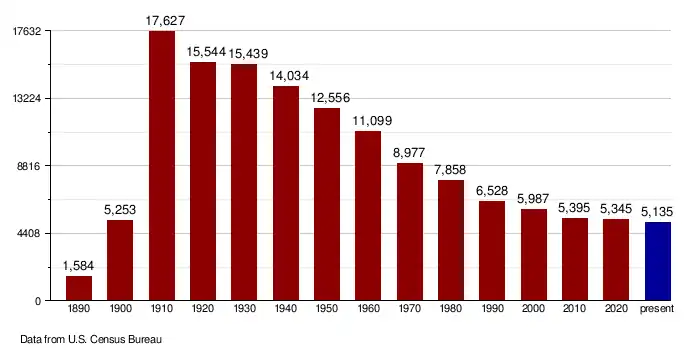
| 1890 | 1,584 | — | |
| 1900 | 5,253 | 231.6% | |
| 1910 | 17,627 | 235.6% | |
| 1920 | 15,544 | −11.8% | |
| 1930 | 15,439 | −0.7% | |
| 1940 | 14,034 | −9.1% | |
| 1950 | 12,556 | −10.5% | |
| 1960 | 11,099 | −11.6% | |
| 1970 | 8,977 | −19.1% | |
| 1980 | 7,858 | −12.5% | |
| 1990 | 6,528 | −16.9% | |
| 2000 | 5,987 | −8.3% | |
| 2010 | 5,395 | −9.9% | |
| 2020 | 5,345 | −0.9% | |
| 2024 (est.) | 5,135 | [10] | −3.9% |
| U.S. Decennial Census[11] 1790–1960[12] 1900–1990[13] 1990–2000[14] 2010–2020[1] | |||
As of the fourth quarter of 2024, the median home value in McHenry County was $151,728.[15]
2020 census
As of the census of 2020, there were 5,345 people. 2,818 houses.
2010 census
As of the census of 2010, there were 5,395 people, 2,377 households, and 1,527 families in the county. The population density was 2.88 people per square mile (1.11 people/km2). There were 2,948 housing units at an average density of 1.57 units per square mile (0.61/km2). The racial makeup of the county was 97.8% white, 0.6% American Indian, 0.3% Asian, 0.1% black or African American, 0.3% from other races, and 0.9% from two or more races. Those of Hispanic or Latino origin made up 1.5% of the population. In terms of ancestry, 55.3% were of German, 39.5% Norwegian, 5.3% English, 3.6% Swedish, 3.5% American, 2.4% Russian and 1.7% Dutch ancestry.
Of the 2,377 households, 25.3% had children under the age of 18 living with them, 53.9% were married couples living together, 5.8% had a female householder with no husband present, 35.8% were non-families, and 31.3% of all households were made up of individuals. The average household size was 2.25 and the average family size was 2.81. The median age was 46.2 years.
The median income for a household in the county was $36,944 and the median income for a family was $54,350. Males had a median income of $36,625 versus $26,205 for females. The per capita income for the county was $22,911. About 6.4% of families and 12.3% of the population were below the poverty line, including 17.1% of those under age 18 and 17.9% of those age 65 or over.
Population by decade
Communities
Cities
Census-designated place
- Bantry (former city)
Unincorporated communities
Source:[6]
Townships
- Anamoose
- Balfour
- Bantry
- Berwick
- Bjornson
- Brown
- Cottonwood Lake
- Deep River
- Deering
- Denbigh
- Egg Creek
- Falsen
- Gilmore
- Granville
- Grilley
- Hendrickson
- Karlsruhe
- Kottke Valley
- Lake George
- Lake Hester
- Land
- Layton
- Lebanon
- Little Deep
- Meadow
- Mouse River
- Newport
- Normal
- North Prairie
- Norwich
- Odin
- Olivia
- Pratt
- Riga
- Rose Hill
- Round Lake
- Saline
- Schiller
- Spring Grove
- Strege
- Velva
- Villard
- Voltaire
- Wagar
- Willow Creek
Notable people
- Sondre Norheim, pioneer of modern skiing
- Cordell Volson, professional football player
Politics
McHenry County voters have traditionally voted Republican. In only one national election since 1936 has the county selected the Democratic Party candidate. In 2024, Donald Trump received the highest percentage of the vote for any presidential candidate in McHenry County's history, receiving over 80% of the vote, breaking his own record that he set in 2020.
| Year | Republican | Democratic | Third party(ies) | |||
|---|---|---|---|---|---|---|
| No. | % | No. | % | No. | % | |
| 2024 | 2,223 | 80.78% | 479 | 17.41% | 50 | 1.82% |
| 2020 | 2,364 | 78.72% | 564 | 18.78% | 75 | 2.50% |
| 2016 | 2,050 | 72.70% | 490 | 17.38% | 280 | 9.93% |
| 2012 | 1,678 | 61.87% | 943 | 34.77% | 91 | 3.36% |
| 2008 | 1,374 | 56.87% | 981 | 40.60% | 61 | 2.52% |
| 2004 | 1,744 | 61.84% | 1,030 | 36.52% | 46 | 1.63% |
| 2000 | 1,682 | 61.45% | 888 | 32.44% | 167 | 6.10% |
| 1996 | 1,187 | 43.07% | 1,096 | 39.77% | 473 | 17.16% |
| 1992 | 1,321 | 38.90% | 1,173 | 34.54% | 902 | 26.56% |
| 1988 | 1,888 | 52.69% | 1,665 | 46.47% | 30 | 0.84% |
| 1984 | 2,485 | 65.38% | 1,283 | 33.75% | 33 | 0.87% |
| 1980 | 2,922 | 71.20% | 939 | 22.88% | 243 | 5.92% |
| 1976 | 2,043 | 49.70% | 1,994 | 48.50% | 74 | 1.80% |
| 1972 | 2,765 | 63.62% | 1,554 | 35.76% | 27 | 0.62% |
| 1968 | 2,226 | 54.21% | 1,595 | 38.85% | 285 | 6.94% |
| 1964 | 1,728 | 39.46% | 2,643 | 60.36% | 8 | 0.18% |
| 1960 | 2,715 | 54.87% | 2,231 | 45.09% | 2 | 0.04% |
| 1956 | 3,019 | 62.12% | 1,825 | 37.55% | 16 | 0.33% |
| 1952 | 4,227 | 76.60% | 1,228 | 22.25% | 63 | 1.14% |
| 1948 | 2,578 | 56.45% | 1,770 | 38.76% | 219 | 4.80% |
| 1944 | 3,141 | 61.44% | 1,934 | 37.83% | 37 | 0.72% |
| 1940 | 3,894 | 63.07% | 2,225 | 36.04% | 55 | 0.89% |
| 1936 | 1,619 | 26.24% | 3,294 | 53.40% | 1,256 | 20.36% |
| 1932 | 1,396 | 25.08% | 3,937 | 70.73% | 233 | 4.19% |
| 1928 | 2,914 | 53.04% | 2,535 | 46.14% | 45 | 0.82% |
| 1924 | 1,692 | 36.89% | 264 | 5.76% | 2,631 | 57.36% |
| 1920 | 3,534 | 74.09% | 848 | 17.78% | 388 | 8.13% |
| 1916 | 692 | 31.33% | 1,316 | 59.57% | 201 | 9.10% |
| 1912 | 589 | 23.61% | 959 | 38.44% | 947 | 37.96% |
| 1908 | 1,772 | 56.16% | 1,296 | 41.08% | 87 | 2.76% |
| 1904 | 1,807 | 73.54% | 556 | 22.63% | 94 | 3.83% |
| 1900 | 595 | 70.00% | 222 | 26.12% | 33 | 3.88% |
See also
References
- ^ a b "State & County QuickFacts". United States Census Bureau. Retrieved April 4, 2023.
- ^ "Find a County". National Association of Counties. Retrieved July 17, 2025.
- ^ "Dakota Territory, South Dakota, and North Dakota: Individual County Chronologies". publications.newberry.org. The Newberry Library. 2006. Retrieved July 17, 2025.
- ^ "County History". www.nd.gov. State of North Dakota. Retrieved July 17, 2025.
- ^ "County History". www.nd.gov. State of North Dakota. Retrieved July 17, 2025.
- ^ a b c "McHenry County · North Dakota". Google Maps. Retrieved April 27, 2024.
- ^ ""Find an Altitude/McHenry County ND" Google Maps (accessed February 23, 2019)". Archived from the original on May 21, 2019. Retrieved February 24, 2019.
- ^ "2024 County Gazetteer Files – North Dakota". United States Census Bureau. Retrieved July 17, 2025.
- ^ "U.S. Census Bureau QuickFacts: McHenry County, North Dakota". www.census.gov. Retrieved July 17, 2025.
- ^ "County Population Totals and Components of Change: 2020-2024". Retrieved June 30, 2025.
- ^ "U.S. Decennial Census". United States Census Bureau. Retrieved July 20, 2014.
- ^ "Historical Census Browser". University of Virginia Library. 2007. Archived from the original on December 12, 2009. Retrieved July 20, 2014.
- ^ Forstall, Richard L. (April 20, 1995). "Population of Counties by Decennial Census: 1900 to 1990". United States Census Bureau. Archived from the original on February 19, 1999. Retrieved July 20, 2014.
- ^ "Census 2000 PHC-T-4. Ranking Tables for Counties: 1990 and 2000" (PDF). United States Census Bureau. Archived (PDF) from the original on March 27, 2010. Retrieved July 20, 2014.
- ^ "County Median Home Price". National Association of Realtors. Retrieved June 30, 2025.
- ^ a b c d e Genealogy Trails: North Dakota (accessed February 23, 2019)
- ^ Leip, David. "Atlas of US Presidential Elections". uselectionatlas.org. Retrieved April 12, 2018.
External links
- McHenry County – official website
- McHenry County maps, Sheet 1 (northern) and Sheet 2 (southern), North Dakota DOT
Places adjacent to McHenry County, North Dakota | ||||||||||||||||
|---|---|---|---|---|---|---|---|---|---|---|---|---|---|---|---|---|
| ||||||||||||||||
Municipalities and communities of , United States | ||
|---|---|---|
| Cities | | |
| Townships |
| |
| Unorganized territories |
| |
| CDP | ||
| Other communities | ||
| Indian reservation | ||
| Footnotes | ‡This populated place also has portions in an adjacent county or counties | |
