Los Alamitos, California
Los Alamitos, California | |
|---|---|
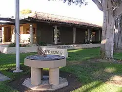 Los Alamitos City Hall | |
 Flag  Seal | |
 Location of Los Alamitos within Orange County, California. | |
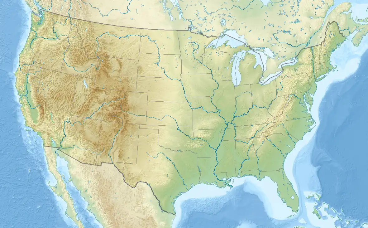 Los Alamitos, California Location in the United States | |
| Coordinates: 33°48′8″N 118°3′52″W / 33.80222°N 118.06444°W / 33.80222; -118.06444 | |
| Country | United States |
| State | California |
| County | Orange |
| Incorporated | March 1, 1960[1] |
| Government | |
| • Type | Council-Manager |
| • Mayor | Shelly Hasselbrink |
| • Mayor Pro Tem | Tanya Doby |
| • City council[2] | Mark Chirco Ron Bates Jordan Nefulda |
| • City Manager | Chet Simmons |
| Area | |
• Total | 4.07 sq mi (10.55 km2) |
| • Land | 4.01 sq mi (10.39 km2) |
| • Water | 0.06 sq mi (0.16 km2) 1.60% |
| Elevation | 23 ft (7 m) |
| Population | |
• Total | 11,780 |
| • Density | 2,900/sq mi (1,100/km2) |
| Time zone | UTC-8 (PST) |
| • Summer (DST) | UTC-7 (PDT) |
| ZIP Codes | 90720–90721 |
| Area code | 562 |
| FIPS code | 06-43224 |
| GNIS feature ID | 1652748 |
| Website | www |
Los Alamitos (lohs al-uh-MEE-tohs; Spanish for 'the little cottonwoods') is a city in Orange County, California. The city was incorporated in March 1960. The population was 11,780 at the 2020 census, up from 11,449 at the 2010 census.
A significant area of the city is taken up by Joint Forces Training Base - Los Alamitos,[6] which also hosts the USA Water Polo National Aquatic Center.[7]
History
The Tongva inhabited this area before the city was formerly established. Rancho Los Alamitos specifically was previously known as the village of Puvunga. Although it is still a sacred land used by the Tongva people.[8]
.jpg)
[[Category:Wikipedia pages tagged for copyright problems|]] The history of the area during the Californio period and after U.S. annexation is detailed in the article on Rancho Los Alamitos. The town of Los Alamitos was established in 1896 by Lewellyn Bixby to support the new sugar beet factory in town built by the extremely wealthy Clark Brothers. William Andrews Clark, a future Senator from Montana, had built his fortune in mining, banking and logging in that state. His younger brother, J. Ross Clark, managed their operations in California after he moved to that state for health reasons. Lewellyn Bixby, whose family owned the surrounding land on the Rancho Los Cerritos and Rancho Los Alamitos, had been trying to build a sugar beet factory in that area for a few years but, due to financial losses in the 1880s, he no longer had the financial capital to undertake the sugar beet factory complex on his own. Bixby had made his fortune back in the 1850s when he and his cousins Benjamin and Thomas Flint, formed Flint, Bixby & Co. which became a thriving entity in mutton and wool, all originally housed on the Rancho San Justo, south of San Jose. After making an additional fortune from selling wool to the government during the Civil War, the Flints and Bixby bought up many properties in Southern California. One was the future Irvine Ranch and another was the Rancho Los Cerritos which makes up much of the western half of Long Beach. Flint, Bixby hired Lewellyn's younger brother Jotham to manage the Cerritos. When Flint, Bixby broke up Lewellyn assumed their Southern California properties and moved to Los Angeles and became the senior partner in his operations with his brother Jotham.
Around 1881, a cousin, John W. Bixby wanted to purchase the Rancho Los Alamitos. John W. put together a consortium of himself, his cousins Lewellyn and Jotham (owners of Rancho Los Cerritos) and banker I.W. Hellman to finance the purchase of the Alamitos land. Upon John's sudden death on May 7, 1887,[10] the ranch was divided between the three owning families. The northern third adjacent to the Rancho Los Cerritos — the land roughly north of present Orangewood Ave.—went to the Lewellyn-Jotham faction (which later became the Bixby Land Company). By the mid-1890s, after the crash following the land boom of the 1880s—this group was relatively cash-poor and land rich. Having experimented in Northern California with sugar beets, the Bixbys agreed to provide the land, and contracted with Montana copper baron William A. Clark to provide the capital, and got E.A. Dyer to provide the expertise to build a new sugar beet factory on the Bixby's land. The community that grew up around this new sugar beet factory complex—with its streets of company houses for workers and surrounding farms—came to be called Los Alamitos. (As part of his arrangement to build and operate the sugar beet factory, William Clark and his brother H. Ross, who actually ran the Los Alamitos operation, also received 1,000 acres east of the factory and a year later completed a purchase of 8,000 acres (32 km2) of land north of the sugar plant—most of the latter in the Rancho Los Cerritos boundaries—that would eventually become the Long Beach Airport, Long Beach City College, and the city of Lakewood. Also, Clark and Hellman were intricately involved with the machinations and corporate dealings of railroad tycoon E. H. Harriman and Henry Edwards Huntington and the destiny of the Southern Pacific in Southern California. In addition, some time after establishing Los Alamitos, the Clarks completed their railroad from Los Angeles to Salt Lake City, establishing the desert stop of Las Vegas in the process.
In the early 1900s, sugar beets were delivered to a factory by horse and wagon. Economics and an elimination of a protective tariff, combined with an insect infestation in 1921, caused sugar-beet crop to drop significantly in Orange County and the eventual demise of the sugar beet industry there and in Los Alamitos. But the town that had sprung up continued to grow.
On the lands south of the factory (and current Orangewood Avenue), Fred H. Bixby, son of John Bixby and future member of the Cowboy Hall of Fame, used his sugar beet lands as a finishing ranch to fatten cattle before sending them off to slaughter (he also managed Hellman's lands in present Seal Beach). Bixby, one of the more progressive ranchers of his time, allowed European immigrant, Mexican, and Japanese farmers to rent the land and grow crops. At the beginning of World War II, the Japanese farmers were rounded up by the military and relocated to internment camps at Manzanar and elsewhere.
Just prior to and during early World War II, the area around Los Alamitos became a major center for the aircraft industry. The Clark heirs arranged for Donald Douglas to begin construction of the Douglas Aircraft Company aircraft plant just north of the Long Beach airport. At the same time the Navy decided it needed an auxiliary airfield for its Reserve Training facility at the increasingly crowded Airport. A touch and go field was built on the level ground just east of Los Alamitos in August 1940. This was the first military post in Orange County. In February 1941, the Navy decided to move all their reserve aviation training from Long Beach and purchased what would become a 1300-acre facility. Trainees and cadre began using the new facilities as early as November 1941, but it wasn't until May 1942 that NRAB Long Beach formally transitioned all operations to NRAB Los Alamitos. The new base provided many jobs and spurred growth in the town. After World War II, NRAB Los Alamitos was the busiest reserve air base in the nation for a while, especially during the Korean War, but by the late 1950s encroaching surrounding suburban residential development began to curtail its activity. The Navy moved out in 1972 and in 1973, the California National Guard took over management of the base, re-designated an Armed Forces Reserve Center. Today, it is a reserve support center for units of the Army, Navy, National Guard and Marines, but is also a home to many other government agencies, including Homeland Security, FEMA and the State of California Office of Emergency Services.[11]
Many former military personnel chose to stay on in Los Alamitos after the war, living in such new neighborhoods as Carrier Row, where streets are named for World War II aircraft carriers, many of which had been the home for Navy pilots trained at Los Alamitos. Carrier Row was actually not one unit, but three small subdivisions built separately in 1947–48, 1950, and 1955 by different builders. The first of these units was the Alamos Ranchos which was first occupied in April 1948. These homes had sewage problems, and the builder stopped after completing only the two blocks east of Lexington and south of Katella. In 1950, two more blocks were constructed under the name of Plainview Homes. Finally, in 1955, the tract was completed with the construction of Los Alamitos Park. Another subdivision of 193 units, Los Alamitos Terrace, was built in the area north of Old Town West, on land once used as grazing land for Bixby-operated dairy farm—whose main headquarters were located where Los Alamitos High School now stands.[11]
But overall, these units were small compared to the next subdivision built in the area. In 1956 builder Ross Cortese purchased land to build the walled community of Rossmoor just southwest from the townsite of Los Alamitos. Rossmoor, still the largest single development in Orange County, was the first walled community in the United States and quickly became home to over 10,000 upper middle class professionals. Rossmoor's homes were designed initially by Earle G. Kaltenbach (who also designed Disneyland's original Tomorrowland), although two of the later phases were designed by Chris Choate, who achieved much fame as the frequent partner of Cliff May. Together the two men were among the most responsible for designing and popularizing the "ranch" style homes which dominated the suburban explosion of the 1950s. Prior to Rossmoor, Choate and May had worked with Cortese on building the nearby Lakewood Rancho Estates in Long Beach.[11]
Although Rossmoor never officially became part of Los Alamitos proper, it has become inextricably linked to the town. When Los Alamitos incorporated in 1960 its population was only about 3,400, while still-growing Rossmoor was nearing 10,000. Now they are fairly equal with Los Alamitos being slightly larger than 11,000. Rossmoor, still an unincorporated part of Orange County, doesn't pay taxes to Los Alamitos, but the city virtually treats Rossmoor residents as if they were residents. In exchange, the city's many youth programs benefit from the overwhelming number of Rossmoor residents who volunteer for those programs, and Rossmoor, having very little commercial areas of its own, contributes much sales tax revenue to Los Alamitos.
The success of Rossmoor quickly led to other subdivisions in Los Alamitos—Dutch Haven (built in 1960 by Luxury Homes, and William G. Lyon), the Rossmoor Highlands (1961), Suburbia, New Dutch Haven, Greenbrook and College Park North (1967).
The small city has been the hometown for a number of noted athletes including baseball Hall of Famer Bob Lemon(although he spent more time in Long Beach), and Olympic gymnast Cathy Rigby. The Los Alamitos youth baseball leagues, which began in 1958 as the Rossmoor Little League and, after moving its fields to the Navy base, eventually changed its name to Los Alamitos Youth baseball - LAYB) has been home to many future major leaguers including Andy Messersmith, who challenged baseball's reserve clause and helped established free agency in professional sports . At one point in the late 1980s, six former league players were playing baseball in the major leagues—Robb Nen, J. T. Snow, Greg Harris, Dennis Lamp, Greg Pirkl, and Mike Kelly. The area is also home to record holding long-distance swimmer Lynne Cox. It was also home to California Supreme Court Chief Justice Malcolm M. Lucas while he served on the Court, and to award-winning mystery writer Jan Burke.
Geography
Los Alamitos is bounded by Cypress to the north and east, West Garden Grove to the east, and Seal Beach to the south. The census-designated place of Rossmoor is enclosed by Los Alamitos to the north, east, and west.[12] The city shares a northwestern border with Los Angeles County's Long Beach, namely the El Dorado Park neighborhood. Coyote Creek serves as a major geographical divider between Los Alamitos and Long Beach.
Biogeography
The most common native species: Hairy Sand Verbena, Red Sand Verbena, and Pink Sand Verbena.
Climate
Gardeners use several climate zone indicators to determine the proper plantings for an area. In the U.S. most plants and seeds are indicated for a particular climate by the USDA Hardiness Zone. A more exact measure is the Sunset zone. In Los Alamitos, the USDA Hardiness Zone is 9.[13] The Sunset climate zone is 22.[14]
| Los Alamitos, California | ||||||||||||||||||||||||||||||||||||||||||||||||||||||||||||
|---|---|---|---|---|---|---|---|---|---|---|---|---|---|---|---|---|---|---|---|---|---|---|---|---|---|---|---|---|---|---|---|---|---|---|---|---|---|---|---|---|---|---|---|---|---|---|---|---|---|---|---|---|---|---|---|---|---|---|---|---|
| Climate chart (explanation) | ||||||||||||||||||||||||||||||||||||||||||||||||||||||||||||
| ||||||||||||||||||||||||||||||||||||||||||||||||||||||||||||
| ||||||||||||||||||||||||||||||||||||||||||||||||||||||||||||
Demographics
| Census | Pop. | Note | %± |
|---|---|---|---|
| 1960 | 4,312 | — | |
| 1970 | 11,346 | 163.1% | |
| 1980 | 11,529 | 1.6% | |
| 1990 | 11,676 | 1.3% | |
| 2000 | 11,536 | −1.2% | |
| 2010 | 11,449 | −0.8% | |
| 2020 | 11,780 | 2.9% | |
| 2024 (est.) | 11,846 | [15] | 0.6% |
| U.S. Decennial Census[16] 1860–1870[17][18] 1880-1890[19] 1900[20] 1910[21] 1920[22] 1930[23] 1940[24] 1950[25] 1960[26] 1970[27] 1980[28] 1990[29] 2000[30] 2010[31] 2020[32] | |||
Los Alamitos was first listed as a city in the 1960 U.S. Census.[26] Prior to 1960, the area was part of Seal Beach Township (pop 6,824 in 1950).[25]
| Race / Ethnicity (NH = Non-Hispanic) | Pop 2000[33] | Pop 2010[34] | Pop 2020[32] | % 2000 | % 2010 | % 2020 |
|---|---|---|---|---|---|---|
| White alone (NH) | 7,836 | 6,721 | 5,449 | 67.93% | 58.70% | 46.26% |
| Black or African American alone (NH) | 358 | 300 | 347 | 3.10% | 2.62% | 2.95% |
| Native American or Alaska Native alone (NH) | 31 | 22 | 34 | 0.27% | 0.19% | 0.29% |
| Asian alone (NH) | 1,090 | 1,447 | 2,060 | 9.45% | 12.64% | 17.49% |
| Native Hawaiian or Pacific Islander alone (NH) | 35 | 47 | 69 | 0.30% | 0.41% | 0.59% |
| Other race alone (NH) | 18 | 46 | 68 | 0.16% | 0.40% | 0.58% |
| Mixed race or Multiracial (NH) | 320 | 448 | 727 | 2.77% | 3.91% | 6.17% |
| Hispanic or Latino (any race) | 1,848 | 2,418 | 3,026 | 16.02% | 21.12% | 25.69% |
| Total | 11,536 | 11,449 | 11,780 | 100.00% | 100.00% | 100.00% |
2020
The 2020 United States census reported that Los Alamitos had a population of 11,780. The population density was 2,938.4 inhabitants per square mile (1,134.5/km2). The racial makeup of Los Alamitos was 53.3% White, 3.3% African American, 0.9% Native American, 17.8% Asian, 0.6% Pacific Islander, 8.5% from other races, and 15.6% from two or more races. Hispanic or Latino of any race were 25.7% of the population.[35]
The census reported that 98.8% of the population lived in households, 0.1% lived in non-institutionalized group quarters, and 1.1% were institutionalized.[35]
There were 4,266 households, out of which 39.2% included children under the age of 18, 48.2% were married-couple households, 5.7% were cohabiting couple households, 30.2% had a female householder with no partner present, and 15.9% had a male householder with no partner present. 21.0% of households were one person, and 10.2% were one person aged 65 or older. The average household size was 2.73.[35] There were 3,104 families (72.8% of all households).[36]
The age distribution was 23.5% under the age of 18, 8.9% aged 18 to 24, 25.4% aged 25 to 44, 26.1% aged 45 to 64, and 16.1% who were 65 years of age or older. The median age was 39.3 years. For every 100 females, there were 91.0 males.[35]
There were 4,376 housing units at an average density of 1,091.5 units per square mile (421.4 units/km2), of which 4,266 (97.5%) were occupied. Of these, 44.4% were owner-occupied, and 55.6% were occupied by renters.[35]
In 2023, the US Census Bureau estimated that the median household income was $98,539, and the per capita income was $51,404. About 7.2% of families and 9.3% of the population were below the poverty line.[37]
2010
The 2010 United States census[38] reported that Los Alamitos had a population of 11,449. The population density was 2,781.8 inhabitants per square mile (1,074.1/km2). The racial makeup of Los Alamitos was 8,131 (71.0%) White (58.7% Non-Hispanic White),[39] 324 (2.8%) African American, 51 (0.4%) Native American, 1,471 (12.8%) Asian, 50 (0.4%) Pacific Islander, 726 (6.3%) from other races, and 696 (6.1%) from two or more races. Hispanic or Latino of any race were 2,418 persons (21.1%).
The Census reported that 11,206 people (97.9% of the population) lived in households, 40 (0.3%) lived in non-institutionalized group quarters, and 203 (1.8%) were institutionalized.
There were 4,212 households, out of which 1,610 (38.2%) had children under the age of 18 living in them, 2,025 (48.1%) were opposite-sex married couples living together, 731 (17.4%) had a female householder with no husband present, 282 (6.7%) had a male householder with no wife present. There were 209 (5.0%) unmarried opposite-sex partnerships, and 19 (0.5%) same-sex married couples or partnerships. 885 households (21.0%) were made up of individuals, and 355 (8.4%) had someone living alone who was 65 years of age or older. The average household size was 2.66. There were 3,038 families (72.1% of all households); the average family size was 3.10.
The population was spread out, with 2,741 people (23.9%) under the age of 18, 1,077 people (9.4%) aged 18 to 24, 2,938 people (25.7%) aged 25 to 44, 3,099 people (27.1%) aged 45 to 64, and 1,594 people (13.9%) who were 65 years of age or older. The median age was 38.7 years. For every 100 females, there were 89.5 males. For every 100 females age 18 and over, there were 87.1 males.
There were 4,355 housing units at an average density of 1,058.2 per square mile (408.6/km2), of which 1,967 (46.7%) were owner-occupied, and 2,245 (53.3%) were occupied by renters. The homeowner vacancy rate was 0.8%; the rental vacancy rate was 3.1%. 5,274 people (46.1% of the population) lived in owner-occupied housing units and 5,932 people (51.8%) lived in rental housing units.
According to the 2010 United States census, Los Alamitos had a median household income of $80,449, with 7.2% of the population living below the federal poverty line.[39]
Government
| Year | Democratic | Republican | Third Parties |
|---|---|---|---|
| 2020[40] | 51.63% 3,192 | 45.74% 2,828 | 2.64% 163 |
| 2016[41] | 47.08% 2,372 | 45.06% 2,270 | 7.86% 396 |
| 2012[42] | 45.11% 2,212 | 51.86% 2,543 | 3.04% 149 |
| 2008[43] | 47.62% 2,436 | 49.98% 2,557 | 2.40% 123 |
| 2004[44] | 42.63% 2,076 | 55.50% 2,703 | 1.87% 91 |
| 2000[45] | 42.97% 1,919 | 52.33% 2,337 | 4.70% 210 |
| 1996[46] | 41.23% 1,733 | 46.75% 1,965 | 12.02% 505 |
| 1992[47] | 36.65% 1,875 | 37.65% 1,926 | 25.70% 1,315 |
| 1988[48] | 36.59% 1,721 | 62.28% 2,929 | 1.13% 53 |
| 1984[49] | 28.65% 1,249 | 70.38% 3,068 | 0.96% 42 |
| 1980[50] | 29.00% 1,246 | 61.38% 2,637 | 9.61% 413 |
The City Council is the legislative body for Los Alamitos and consists of five members that are voted by and represent each of their respective districts. Annually, the first city council meeting focuses on appointing one of its members to be mayor of the city for the year. Following the selection of a mayor, the newly appointed mayor holds a city council election to appoint one of them as the mayor pro tempore.[51] Shelley Hasselbrink is the mayor.[52]
State, federal, and county representation
In the California State Legislature, Los Alamitos is in the 36th senatorial district, represented by Republican Tony Strickland, and in the 70th Assembly district, represented by Republican Tri Ta[53]
In the United States House of Representatives, Los Alamitos is in California's 45th congressional district, represented by Democrat Derek Tran.[54]
Additionally, in the Orange County Board of Supervisors, Los Alamitos is in the first district, represented by Janet Nguyen since 2024.
According to the Orange County Registrar of Voters, as of May 17, 2025, Los Alamitos has 7,526 registered voters.[55] Of those, 2,676 are registered Republicans, 2,725 are registered Democrats, and 1,577 (26.72%) have declined to state a political party/are independents.[56]
Economy
The first Claim Jumper restaurant opened in Los Alamitos in 1977. The location closed and is now a Hof's Hut. Neverland Studios, a recording studio that was often used by Christian rock bands, was originally located in Los Alamitos. Tillys had its original location in Los Alamitos.
Top employers
According to the City's 2022 Comprehensive Annual Financial Report,[57] the top employers in the city are:
| # | Employer | # of employees |
|---|---|---|
| 1 | UCI Health - Los Alamitos | 1,100 |
| 2 | Arrowhead Products | 780 |
| 3 | Trend Offset Printing | 700 |
| 4 | Epson America | 693 |
| 5 | Mittera California, Inc. | 238 |
| 6 | Discovery Practice Management, Inc | 205 |
| 7 | Bar Bakers, LLC | 200 |
| 8 | Resare Marketing, Inc | 191 |
| 9 | Alamitos West Health & Rehabilitation | 145 |
| 9 | Evergreen Pharmaceutical of California, Inc. | 145 |
| 9 | Katella Delicatessen-Restaurant-Bakery, Inc. | 145 |
Infrastructure
Transportation
Orange County Transportation Authority operates bus service in Los Alamitos.[58][59]
Water Services
Water in Los Alamitos is supplied by the Golden State Water,[60] which sources its water from the Metropolitan Water District of Southern California, importing water from the Colorado River Aqueduct and the State Water Project. In addition, groundwater is pumped from the Orange County Groundwater Basin.[61]
Notable people
- Dana Andrews, actor
- Aaron Barrett (born 1974), musician, Founding member of Reel Big Fish
- Jonathan Bornstein (born 1984), soccer player for USA National Team, Chivas USA, and Chicago Fire
- Tim Carey, football player—attended Los Alamitos HS, but grew up in Seal Beach
- Kami Cotler (born 1965), actress
- Lynne Cox, long-distance swimmer
- Troy Edgar, American security official
- Landry Fields, basketball player for New York Knicks of the NBA—attended Los Alamitos HS, but grew up in Long Beach
- Scott Klopfenstein, musician, former member of Reel Big Fish
- Chris Kluwe, former punter for the Minnesota Vikings of the NFL—attended Los Alamitos HS, but grew up in Seal Beach
- Bob Lemon, baseball Hall of Famer as pitcher and manager, lived in City Garden Acres (now Apartment Row) and attended Laurel Elementary before family moved to Long Beach
- Marcedes Lewis, tight end for the Green Bay Packers of the NFL
- Allison Mack, actress (known as "Chloe" from Smallville)
- Taryn Manning (born 1978), actress
- Matthew Morrison, singer and actor (Broadway plays, Fox TV's Glee) -- attended Los Alamitos HS, but grew up in Cypress
- Tony Muser, former MLB player and manager
- Robb Nen, baseball player—attended Los Alamitos HS, but grew up in Seal Beach
- Cathy Rigby, Olympic gymnast and actress
- Matt "Money" Smith, Fox Sports Radio talk show host
- J.T. Snow (born 1968), baseball player—attended Los Alamitos HS, but grew up in Seal Beach
- Jodie Sweetin, actress ("Stephanie Tanner" from Full House)
- Ralph Flanagan (swimmer), Olympic swimmer
- Nikki Monninger, bass guitarist for Silversun Pickups
Schools
It is a part of the Los Alamitos Unified School District, which began in 1898 as the Laurel Elementary School District, and changed its name in 1953 to the Los Alamitos Elementary School District, providing education up through sixth grade. Students in Grades 7-12 attended schools in the Anaheim School District, until 1979 when local voters, after a few failed attempts, finally received state permission to hold an election, and voted to withdraw from the Anaheim High School District and unify all their local grades under the name the Los Alamitos Unified School District.
- Los Alamitos High School (opened September 1967, moved into current permanent location in September 1968)
- Laurel High School (continuation school, absorbed into Los Alamitos High School in 2014)
- McAuliffe Middle School (originally named Pine Jr. High)
- Oak Middle School (originally named Oak Jr. High)
- Hopkinson Elementary in Rossmoor, California
- Lee Elementary in Rossmoor, California
- Los Alamitos Elementary
- Rossmoor Elementary in Rossmoor, California
- Weaver Elementary in Rossmoor, California
- McGaugh Elementary in Seal Beach, California
- St. Hedwig School, a K–8 private school
Friendship cities
.svg.png) Cranbourne, Australia
Cranbourne, Australia
References
- ^ "California Cities by Incorporation Date". California Association of Local Agency Formation Commissions. Archived from the original (Word) on November 3, 2014. Retrieved August 25, 2014.
- ^ "City Council". City of Los Alamitos. Retrieved January 29, 2022.
- ^ "2019 U.S. Gazetteer Files". United States Census Bureau. Retrieved July 1, 2020.
- ^ "Los Alamitos". Geographic Names Information System. United States Geological Survey, United States Department of the Interior. Retrieved October 10, 2014.
- ^ "Los Alamitos city, California Quickfacts". United States Census Bureau.
- ^ "Los Alamitos Joint Forces Training Base".
- ^ "USA Water Polo - Official Athletics Website".
- ^ "History of the Site". Rancho Los Alamitos. Retrieved May 15, 2025.
- ^ "PCAD - Los Alamitos Sugar Company, Sugar Beet Factory, Los Alamitos, CA". pcad.lib.washington.edu.
- ^ "Los Angeles Herald 8 May 1887 — California Digital Newspaper Collection".
- ^ a b c Strawther, Larry; "A Brief History of Los Alamitos," History Press, 2012
- ^ "City Boundaries". Orange County GIS. Retrieved January 24, 2021.
- ^ Jordan, Ramon. "National Arboretum - USDA Plant Hardiness Zone Map". www.usna.usda.gov. Archived from the original on April 22, 2001. Retrieved October 21, 2016.
- ^ "Flowers and Plants". Sunset. Retrieved October 21, 2016.
- ^ "City and Town Population Totals: 2020-2024". United States Census Bureau. Retrieved June 24, 2025.
- ^ "Decennial Census by Decade". United States Census Bureau. Archived from the original on July 6, 2022.
- ^ "1870 Census of Population - Population of Civil Divisions less than Counties - California - Almeda County to Sutter County" (PDF). United States Census Bureau. Archived (PDF) from the original on September 7, 2024. Retrieved August 12, 2024.
- ^ "1870 Census of Population - Population of Civil Divisions less than Counties - California - Tehama County to Yuba County" (PDF). United States Census Bureau. Archived (PDF) from the original on August 28, 2024. Retrieved August 12, 2024.
- ^ "1890 Census of Population - Population of California by Minor Civil Divisions" (PDF). United States Census Bureau.
- ^ "1900 Census of Population - Population of California by Counties and Minor Civil Divisions" (PDF). United States Census Bureau. Archived (PDF) from the original on August 12, 2024. Retrieved August 12, 2024.
- ^ "1910 Census of Population - Supplement for California" (PDF). United States Census Bureau. Archived (PDF) from the original on August 23, 2024. Retrieved August 12, 2024.
- ^ "1920 Census of Population - Number of Inhabitants - California" (PDF). United States Census Bureau.
- ^ "1930 Census of Population - Number and Distribution of Inhabitants - California" (PDF). United States Census Bureau. Archived (PDF) from the original on August 28, 2024. Retrieved August 12, 2024.
- ^ "1940 Census of Population - Number of Inhabitants - California" (PDF). United States Census Bureau. Archived (PDF) from the original on September 18, 2024. Retrieved August 12, 2024.
- ^ a b "1950 Census of Population - Number of Inhabitants - California" (PDF). United States Census Bureau. Archived (PDF) from the original on September 21, 2024. Retrieved August 12, 2024.
- ^ a b "1960 Census of Population - General population Characteristics - California" (PDF). United States Census Bureau. Archived (PDF) from the original on August 12, 2024. Retrieved August 12, 2024.
- ^ "1970 Census of Population - Number of Inhabitants - California" (PDF). United States Census Bureau. Archived (PDF) from the original on August 12, 2024. Retrieved August 12, 2024.
- ^ "1980 Census of Population - Number of Inhabitants - California" (PDF). United States Census Bureau. Archived (PDF) from the original on August 23, 2024. Retrieved August 12, 2024.
- ^ "1990 Census of Population - Population and Housing Unit Counts - California" (PDF). United States Census Bureau. Archived (PDF) from the original on August 14, 2024. Retrieved August 12, 2024.
- ^ "2000 Census of Population - Population and Housing Unit Counts - California" (PDF). United States Census Bureau.
- ^ "2010 Census of Population - Population and Housing Unit Counts - California" (PDF). United States Census Bureau. Archived (PDF) from the original on February 4, 2023. Retrieved August 12, 2024.
- ^ a b "P2: Hispanic or Latino, and Not Hispanic or Latino by Race – 2020: DEC Redistricting Data (PL 94-171) – Los Alamitos city, California". United States Census Bureau.
- ^ "P004: Hispanic or Latino, and Not Hispanic or Latino by Race – 2000: DEC Summary File 1 – Los Alamitos city, California". United States Census Bureau.
- ^ "P2: Hispanic or Latino, and Not Hispanic or Latino by Race – 2010: DEC Redistricting Data (PL 94-171) – Los Alamitos city, California". United States Census Bureau.
- ^ a b c d e "Los Alamitos city, California; DP1: Profile of General Population and Housing Characteristics - 2020 Census of Population and Housing". US Census Bureau. Retrieved June 24, 2025.
- ^ "Los Alamitos city, California; P16: Household Type - 2020 Census of Population and Housing". US Census Bureau. Retrieved June 24, 2025.
- ^ "Los Alamitos city, California; DP03: Selected Economic Characteristics - 2023 ACS 5-Year Estimates Comparison Profiles". US Census Bureau. Retrieved June 24, 2025.
- ^ "2010 Census Interactive Population Search: CA - Los Alamitos city". U.S. Census Bureau. Archived from the original on July 15, 2014. Retrieved July 12, 2014.
- ^ a b "Los Alamitos (City) QuickFacts from the US Census Bureau". Archived from the original on October 30, 2013. Retrieved December 18, 2013.
- ^ "Votes cast" (PDF). www.ocvote.com. Retrieved January 18, 2021.
- ^ "Votes cast" (PDF). www.ocvote.com. Retrieved July 26, 2020.
- ^ "Votes cast" (PDF). www.ocvote.com. Retrieved July 26, 2020.
- ^ "Votes cast" (PDF). www.ocvote.com. Retrieved July 26, 2020.
- ^ "Votes cast" (PDF). www.ocvote.com. Retrieved July 26, 2020.
- ^ "Votes cast" (PDF). www.ocvote.com. Retrieved July 26, 2020.
- ^ California. Secretary of State (March 30, 1968). "Statement of vote". Sacramento, Calif. : The Secretary – via Internet Archive.
- ^ California. Secretary of State (March 30, 1968). "Statement of vote". Sacramento, Calif. : The Secretary – via Internet Archive.
- ^ Statement of the Vote. Sacramento, Calif. : The Secretary. 1968.
- ^ Statement of the Vote. Sacramento, Calif. : The Secretary. 1968.
- ^ Statement of the Vote. Sacramento, Calif. : The Secretary. 1968.
- ^ "City Council | Los Alamitos, CA". cityoflosalamitos.org. Retrieved May 16, 2025.
- ^ https://cityoflosalamitos.org/165/City-Council 2024-25
- ^ "California Districts". UC Regents. Retrieved January 5, 2023.
- ^ "California's 45th Congressional District - Representatives & District Map". Civic Impulse, LLC. Retrieved January 5, 2023.
- ^ "Experience". experience.arcgis.com. Retrieved May 17, 2025.
- ^ "Experience". ocgov.com. Retrieved May 14, 2025.
- ^ City of Los Alamitos CAFR
- ^ "2024 Los Alamitos Fact Sheet" (PDF). www.octa.net. Retrieved May 11, 2025.
- ^ "Routes and Schedules". Orange County Transportation Authority. Retrieved May 12, 2025.
- ^ "Golden State Water Company | Los Alamitos, CA". cityoflosalamitos.org. Retrieved May 24, 2025.
- ^ water-quality-west-orange-county 2024
External links
- Official website

- Los Alamitos Chamber of Commerce: History
- Local History for Los Alamitos, Rossmoor & Seal Beach


Authority control databases | |
|---|---|
| International | |
| National | |
| Geographic | |
| Other | |