Lao Khwan district
Lao Khwan
เลาขวัญ | |
|---|---|
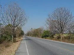 Road 3306, tambon Lao Khwan | |
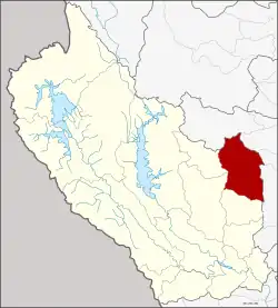 District location in Kanchanaburi province | |
| Coordinates: 14°35′47″N 99°46′29″E / 14.59639°N 99.77472°E | |
| Country | |
| Province | |
| Seat | Lao Khwan |
| Area | |
• Total | 831 km2 (321 sq mi) |
| Population (2024)[2] | |
• Total | 58,587 |
| • Density | 70/km2 (200/sq mi) |
| Time zone | UTC+7 (ICT) |
| Postal code | 71210 |
| Calling code | 034 |
| ISO 3166 code | TH-7110 |
Lao Khwan (Thai: เลาขวัญ, pronounced [lāw kʰwǎn]) is a district (amphoe) in the northeastern part of Kanchanaburi province, central Thailand.
History
Laotian people moved to establish a new village in the area of Ban Ko Ban Kao. Later people from Bo Phloi moved to the area. When the government established a new town, they named it Ban Lao Khwan.
The minor district (king amphoe) Lao Khwan was created on 12 October 1971, when the three subdistricts (tambons)
Lao Khwan, Nong Son, and Nong Pradu were split off from Phanom Thuan district.[3] It was upgraded to a full district on 8 September 1976.[4]
Geography
Neighboring districts are (from the south clockwise) Huai Krachao, Bo Phloi, Nong Prue of Kanchanaburi Province, Dan Chang, Nong Ya Sai, Don Chedi and U Thong of Suphanburi province.
Administration
Provincial administration
The district is divided into seven subdistricts (tambons), which are further subdivided into 90 administrative villages (mubans).[2]
| No. | Subdistrict | Thai | Villages | Pop. |
|---|---|---|---|---|
| 1. | Lao Khwan | เลาขวัญ | 16 | 9,815 |
| 2. | Nong Son | หนองโสน | 11 | 8,230 |
| 3. | Nong Pradu | หนองประดู่ | 12 | 10,011 |
| 4. | Nong Pling | หนองปลิง | 18 | 9,405 |
| 5. | Nong Nok Kaeo | หนองนกแก้ว | 10 | 6,237 |
| 6. | Thung Krabam | ทุ่งกระบ่ำ | 14 | 6,980 |
| 7. | Nong Fai | หนองฝ้าย | 9 | 7,909 |
| Total | 90 | 58,587 |
Local government
Municipalities
As of December 2024 there are two municipal (thesaban) areas in the district: Lao Khwan and Nong Fai subdistrict municipalities (thesaban tambon) cover parts of the same-named subdistricts.[5]
| Subdistrict municipality | Pop. | LAO code | website |
|---|---|---|---|
| Lao Khwan | 2,648 | 05711001 | laokwan |
| Nong Fai | 2,203 | 05711002 | nongfai |
Subdistrict administrative organizations
The non-municipal areas are administered by seven subdistrict administrative organizations - SAO (ongkan borihan suan tambon - o bo toh).[5]
| Subdistrict adm.org - SAO | Pop. | LAO code | website |
|---|---|---|---|
| Nong Pradu SAO | 10,011 | 06711004 | nongpradu |
| Nong Pling SAO | 9,405 | 06711005 | nongpling |
| Nong Son SAO | 8,230 | 06711007 | nongsano-kan |
| Lao Khwan SAO | 7,167 | 06711003 | laokhaun |
| Thung Krabam SAO | 6,980 | 06711008 | thungkrabam |
| Nong Nok Kaeo SAO | 6,237 | 06711009 | nongnokkaew |
| Nong Fai SAO | 5,706 | 06711006 | hnongfai |
Education
- 42 primary schools
- 2 secondary schools[6]
Healthcare
Hospitals
Lao Khwan district is served by one hospital
- Lao Khwan Hospital with 54 beds.
Health promoting hospitals
In the district there are thirteen health-promoting hospitals in total.[7]
| 1 Lao Khwan | 2 Nong Fai | 2 Nong Nok Kaeo | 2 Nong Pling |
| 2 Nong Pradu | 2 Nong Son | 2 Thung Krabam |
Religion
There are sixty-eight Theravada Buddhist temples in the district.[8]
| 3 Nong Fai | 6 Nong Nok Kaeo | 9 Thung Krabam | 11 Lao Khwan |
| 12 Nong Son | 13 Nong Pradu | 14 Nong Pling |
The Christians have two churches.[9]
References
- ^ "Administrative Subdivisions of Countries". Retrieved 15 July 2025.
- ^ a b
"Official statistics registration systems". Department of Provincial Administration (DOPA). Retrieved 15 July 2025, year 2024 >subdistrict level >Excel File >no.71100100-71100700, 7175, 7176 >Excel line 8963-8970, 9001-9004
{{cite web}}: CS1 maint: postscript (link) - ^ "ประกาศกระทรวงมหาดไทย เรึ่อง แบ่งท้องที่อำเภอพนมทวน จังหวัดกาญจนบุรี ตั้งเป็นกิ่งอำเภอเลาขวัญ" [Announcement of the Ministry of Interior on the division of Phanom Thuan district, Kanchanaburi province, to establish Lao Khwan minor district] (PDF). Royal Gazette (in Thai). 88 (109 ก): 2802. 12 October 1971. Retrieved 15 July 2025.
- ^ "พระราชกฤษฎีกาตั้งอำเภอเลาขวัญ อำเภอคำม่วง ๆ พ.ศ.๒๕๑๙" [Royal decree on establishing Lao Khwan district, Khan Muang district, etc. B.E. 2519 (1976)] (PDF). Royal Gazette (in Thai). 93 (109 ก): 31-34. 8 September 1976. Retrieved 15 July 2025.
- ^ a b "Local Government Organization Code". DLA. Retrieved 15 July 2025.
- ^
"Education". Kanchanaburi Provincial Statistical Report 2567-2024. Kanchanaburi Provincial Statistical Office (Report). National Statistical Office (NSO). 2024. ISSN 1905-8314, Education Statistics tabel 3.2 Schools by Level of Education and District: Academic Year 2023
{{cite report}}: CS1 maint: postscript (link) - ^
"Name-of-the-hospital-service-unit". Ministry of Public Health. Retrieved 15 July 2025, >health zone 5 no.08118-08130
{{cite web}}: CS1 maint: postscript (link) - ^
"list of temples". Retrieved 15 July 2025, Sect Maha Nikai 68 temples no.271100101-271100703
{{cite web}}: CS1 maint: postscript (link) - ^
"Religion". Kanchanaburi Provincial Statistical Report 2567-2024. Kanchanaburi Provincial Statistical Office (Report). National Statistical Office (NSO). 2024. ISSN 1905-8314, Religion Statistics tabel 4.1 Temple, Church, Mosque by District 2023
{{cite report}}: CS1 maint: postscript (link)