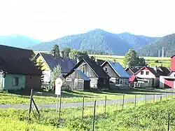
Kráľova Lehota
Kráľova Lehota | |
|---|---|
 | |
 Flag | |
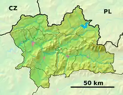 Kráľova Lehota Location of Kráľova Lehota in the Žilina Region  Kráľova Lehota Location of Kráľova Lehota in Slovakia | |
| Coordinates: 49°01′N 19°47′E / 49.02°N 19.79°E | |
| Country | |
| Region | |
| District | Liptovský Mikuláš District |
| First mentioned | 1361 |
| Area | |
• Total | 19.61 km2 (7.57 sq mi) |
| Elevation | 674 m (2,211 ft) |
| Population (2021)[3] | |
• Total | 600 |
| Time zone | UTC+1 (CET) |
| • Summer (DST) | UTC+2 (CEST) |
| Postal code | 323 3[2] |
| Area code | +421 44[2] |
| Car plate | LM |
| Website | www |
Kráľova Lehota (Hungarian: Királylehota) is a village and municipality in Liptovský Mikuláš District in the Žilina Region of northern Slovakia.
History
In historical records the village was first mentioned in 1361. Before the establishment of independent Czechoslovakia in 1918, it was part of Liptó County within the Kingdom of Hungary. From 1939 to 1945, it was part of the Slovak Republic.
Geography
The municipality lies at an altitude of 677 metres and covers an area of 19.609 km2. It has a population of about 634 people.
Genealogical resources
The records for genealogical research are available at the state archive "Statny Archiv in Bytca, Slovakia"
- Roman Catholic church records (births/marriages/deaths): 1675-1923 (parish B)
- Lutheran church records (births/marriages/deaths): 1784-1897 (parish A)
See also
References
- ^ "Hustota obyvateľstva - obce [om7014rr_ukaz: Rozloha (Štvorcový meter)]". www.statistics.sk (in Slovak). Statistical Office of the Slovak Republic. 2022-03-31. Retrieved 2022-03-31.
- ^ a b c "Základná charakteristika". www.statistics.sk (in Slovak). Statistical Office of the Slovak Republic. 2015-04-17. Retrieved 2022-03-31.
- ^ "Počet obyvateľov podľa pohlavia - obce (ročne)". www.statistics.sk (in Slovak). Statistical Office of the Slovak Republic. 2022-03-31. Retrieved 2022-03-31.
External links
- http://www.kralovalehota.sk (added by Andrej Hyben)
- Surnames of living people in Kralova Lehota