Koundian, Mali
Koundian | |
|---|---|
Commune and town | |
 | |
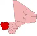
 Koundian Location in Mali | |
| Coordinates: 13°09′35″N 10°40′50″W / 13.15972°N 10.68056°W | |
| Country | |
| Region | Kayes Region |
| Cercle | Bafoulabé Cercle |
| Population (2009 census)[1] | |
• Total | 14,075 |
| Time zone | UTC+0 (GMT) |
Koundian is a small town and commune in the Cercle of Bafoulabé in the Kayes Region of south-western Mali. In the 2009 census the commune had a population of 14,075.
The Toucouleur leader El Hadj Umar Tall built a tata near the village in 1857.[2] The design and construction, which took 5 months, was supervised by the engineer Samba Ndiaye. Along with the tatas of Koniakary, Saboucire, and Mourgala, it protected the heart of the Toucouleur Empire from French encroachment. The fort was captured by French troops led by Louis Archinard on February 18th, 1889, and dismantled.[3]
References
- ^ Resultats Provisoires RGPH 2009 (Région de Kayes) (PDF) (in French), République de Mali: Institut National de la Statistique, archived from the original (PDF) on July 27, 2012
{{citation}}: CS1 maint: publisher location (link). - ^ Meillassoux 1966, p. 42.
- ^ Therno Mouctar Bah. “SAMBA NDIAYE, INGENIEUR DES ARMEES TOUCOULEUR D’EL HADJ OMAR.” Journal of the Historical Society of Nigeria, vol. 8, no. 4, 1977, pp. 161–68. JSTOR, http://www.jstor.org/stable/44734378. Accessed 17 Aug. 2025.
Sources
- Meillassoux, C. (1966), "Plans d'anciennes fortifications (Tata) en pays Malinké", Journal de la Société des Africanistes (in French), 36 (1): 29–44, doi:10.3406/jafr.1966.1403. Page 42 contains a plan of the village showing the fort.
External links
- Plan de Sécurité Alimentaire Commune rurale de Koundian 2007-2009 (PDF) (in French), Commissariat à la Sécurité Alimentaire, République du Mali, USAID-Mali, 2006, archived from the original (PDF) on 2012-06-11, retrieved 2012-03-17.