Koniakary Tata
| Koniakary Tata | |
|---|---|
| Koniakary in Mali | |
 | |
| Site information | |
| Type | Tata (fortification) |
| Location | |
| Coordinates | 14°34′51″N 10°53′57″W / 14.58083°N 10.89917°W |
| Site history | |
| Built | 1855 |
| In use | Toucouleur Empire |
The tata of Koniakary is a tata built in the commune of Koniakary, 70 km (43 mi) from Kayes in Mali. It was constructed beginning in 1854 by Buna Ndiaye, an engineer serving under El Hadj Oumar Tall.[1] Inaugurated in January 1857, its goal was to defend the province of Jambukhu against colonial troops and their allies.[2]
Presentation
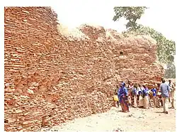
The tata had a rectangular form 115 metres (377 ft) long by 107 metres (351 ft) wide. It measured 6 metres (20 ft) high with a thickness at the base of 2 metres (6 ft 7 in).[3]
The tata, with its eight towers, was built in flat stone, which was quarried 2.5 km (1.6 mi) from the site.
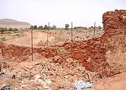
The French expedition to take Nioro du Sahel left after the destruction of the Koniakary tata by colonel Louis Archinard, June 15, 1890.
November 14, 2011 the Council of Ministers of Mali adopted a decree to classify the Koniakary tata as part of the national cultural patrimony of Mali.[4]
The remains of the defensive wall are still visible today.
See also
References
- ^ Therno Mouctar Bah. “SAMBA NDIAYE, INGENIEUR DES ARMEES TOUCOULEUR D’EL HADJ OMAR.” Journal of the Historical Society of Nigeria, vol. 8, no. 4, 1977, pp. 161–68. JSTOR, http://www.jstor.org/stable/44734378. Accessed 17 Aug. 2025.
- ^ Ly-Tall, Madina (1989). "Massina and the Torodbe (Tukuloor) empire until 1878". In Ajayi, Jacob F. Ade (ed.). Africa in the Nineteenth Century Until the 1880s. University of California Press. p. 626. ISBN 9780520039179.
- ^ "Journées touristiques et culturelles de Kayes-Médine : La Commune urbaine de Koniakary dévoile ses merveilles". Malikounda.com. 23 February 2006. Retrieved 26 February 2013.
- ^ Gouvernement (23 November 2011). "Conseil des Ministres du 23 novembre 2011". Journaldumali.com. Archived from the original on 8 March 2012.