Khalifeh Hesar
Khalifeh Hesar
Persian: خليفه حصار | |
|---|---|
Village | |
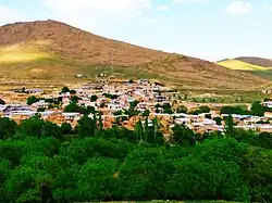 The village of Khalifeh Hesar | |
 Khalifeh Hesar | |
| Coordinates: 36°01′05″N 49°12′35″E / 36.01806°N 49.20972°E[1] | |
| Country | Iran |
| Province | Zanjan |
| County | Abhar |
| District | Central |
| Rural District | Darsajin |
| Established | Before Islam[a] |
| Population (2016)[2] | |
• Total | 77 |
| Time zone | UTC+3:30 (IRST) |
Khalifeh Hesar (Persian: خليفه حصار)[b] is a village in Darsajin Rural District[4] of the Central District in Abhar County, Zanjan province, Iran.
Demographics
Population
At the time of the 2006 National Census, the village's population was 192 in 51 households.[5] The following census in 2011 counted 130 people in 46 households.[6] The 2016 census measured the population of the village as 77 people in 37 households.[2]
Antiquities
The ancient cemetery of this village called White Hill, which belongs to the Seljuk era, has been registered in the list of national monuments of Iran.[7]
Weather
| Khalifeh Hesar | ||||||||||||||||||||||||||||||||||||||||||||||||||||||||||||
|---|---|---|---|---|---|---|---|---|---|---|---|---|---|---|---|---|---|---|---|---|---|---|---|---|---|---|---|---|---|---|---|---|---|---|---|---|---|---|---|---|---|---|---|---|---|---|---|---|---|---|---|---|---|---|---|---|---|---|---|---|
| Climate chart (explanation) | ||||||||||||||||||||||||||||||||||||||||||||||||||||||||||||
| ||||||||||||||||||||||||||||||||||||||||||||||||||||||||||||
| ||||||||||||||||||||||||||||||||||||||||||||||||||||||||||||
Gallery
-
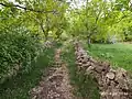 Khalifeh Hesar Alley
 -
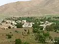 On top of the surrounding mountains
 -
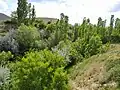 Natural landscape of trees
See also
Notes
References
- ^ OpenStreetMap contributors (28 April 2025). "Khalifa Hesar and Milan, Darsajin RD, Abhar Central District, Abhar County, Zanjan Province, Iran" (Map). OpenStreetMap (in Persian). Retrieved 28 April 2025.
- ^ a b سرشماري عمومي نفوس و مسكن 1395 : استان زنجان [General Population and Housing Census 2016: Zanjan Province]. مرکز آمار ایران [Statistical Centre of Iran] (in Persian). Archived from the original (Excel) on 27 April 2022. Retrieved 19 December 2022.
- ^ Khalifeh Hesar can be found at GEOnet Names Server, at this link, by opening the Advanced Search box, entering "-3070437" in the "Unique Feature Id" form, and clicking on "Search Database".
- ^ Mousavi, Mir-Hossein (22 April 1987) [تاریخ تصویب (Approval date) 1366/02/02 (Iranian Jalali calendar)]. ایجاد و تشکیل تعداد 9 دهستان شامل روستاها، مزارع و مکانها واقع در شهرستان ابهر تابع استان زنجان [Creation and formation of nine rural districts including villages, farms and places located in Abhar County under Zanjan province]. لام تا کام [Lam ta Kam] (in Persian). وزارت کشور [Ministry of the Interior]. هیات وزیران [Council of Ministers]. شناسه [ID] 10E8D2EA-34D4-4263-9C5A-723F410138CB. شماره دوره [Course number] 66, شماره جلد [Volume number] 2. Archived from the original on 25 June 2025. Retrieved 25 June 2025.
- ^ سرشماري عمومي نفوس و مسكن 1385 : استان زنجان [General Population and Housing Census 2006: Zanjan Province]. مرکز آمار ایران [Statistical Centre of Iran] (in Persian). Archived from the original (Excel) on 20 September 2011. Retrieved 25 September 2022.
- ^ سرشماري عمومي نفوس و مسكن 1390 : استان زنجان [General Population and Housing Census 2011: Zanjan Province]. Iran Data Portal—Syracuse University (in Persian). مرکز آمار ایران [Statistical Centre of Iran]. Archived from the original (Excel) on 21 January 2023. Retrieved 19 December 2022.
- ^ "دانشنامهٔ تاریخ معماری و شهرسازی ایرانشهر". وزارت راه و شهرسازی. Archived from the original on 6 October 2019. Retrieved 10 October 2019.
Zanjan province, Iran | ||||||||||||||||
|---|---|---|---|---|---|---|---|---|---|---|---|---|---|---|---|---|
Capital: Zanjan | ||||||||||||||||
| Counties and cities |
|  | ||||||||||||||
| Sights |
| |||||||||||||||
| populated places | ||||||||||||||||