Strong, Ontario
Strong | |
|---|---|
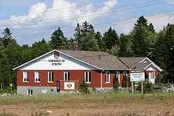
| Township of Strong | |
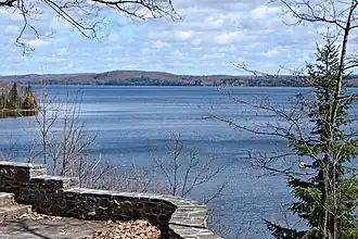 Lake Bernard in Strong Township | |
| Motto: Together for a strong tomorrow | |
 Strong | |
| Coordinates: 45°45′N 79°24′W / 45.750°N 79.400°W | |
| Country | Canada |
| Province | Ontario |
| District | Parry Sound |
| Settled | 1876 |
| Incorporated | 1877 |
| Government | |
| • Type | Township |
| • Mayor | Tim Bryson |
| • Fed. riding | Parry Sound-Muskoka |
| • Prov. riding | Parry Sound—Muskoka |
| Area | |
| • Land | 158.88 km2 (61.34 sq mi) |
| Population (2021)[1] | |
• Total | 1,566 |
| • Density | 9.9/km2 (26/sq mi) |
| Time zone | UTC-5 (EST) |
| • Summer (DST) | UTC-4 (EDT) |
| Postal Code | P0A |
| Area codes | 705, 249 |
| Website | www |
Strong is a township in the Canadian province of Ontario, as well as the name of a community within the township. Located in the Almaguin Highlands region of Parry Sound District, the township surrounds but does not include the village of Sundridge.
The township includes the communities of Hartfell, Kennedys, Lake Bernard, Pevensey, Stirling Falls, and Strong. It is home to Lake Bernard.
Strong Township is accessible via Highway 11 and Highway 124. It is bisected by the CN railway.[2]
History
Settlement of the township began after the The Free Grants and Homestead Act of 1868, with the first settlers arriving in 1876. The Township of Strong was incorporated the following year.[2]
In 1885, the Northern and Pacific Junction Railway (now CN) was built through the township. In 1889, the village of Sundridge split off from the township to form a separate village municipality.[3]
Demographics
In the 2021 Census of Population conducted by Statistics Canada, Strong had a population of 1,566 living in 660 of its 953 total private dwellings, a change of 8.8% from its 2016 population of 1,439. With a land area of 158.88 km2 (61.34 sq mi), it had a population density of 9.9/km2 (25.5/sq mi) in 2021.[1]
|
|
| |||||||||||||||||||||||||||||||||||||||||||||||||||||||||||||||||||||||||||
| Population counts are not adjusted for boundary changes. Source: Statistics Canada[1][4][5][6][7][8] | |||||||||||||||||||||||||||||||||||||||||||||||||||||||||||||||||||||||||||||
Mother tongue (2021):[1]
- English as first language: 95.8%
- French as first language: 0.6%
- English and French as first languages: 0%
- Other as first language: 3.5%
See also
References
- ^ a b c d e "Strong, Ontario (Code 3549046) Census Profile". 2021 census. Government of Canada - Statistics Canada. Retrieved 2025-08-05.
- ^ a b "Community Profile". www.strongtownship.com. Township of Strong. 2025. Retrieved 5 August 2025.
- ^ "History and Heritage". www.sundridge.ca. Village of Sundridge. 2025. Retrieved 5 August 2025.
- ^ 1996, 2001, 2006 census
- ^ Statistics Canada 2011 Census - Strong Census Profile
- ^ "Census Profile, 2016 Census Strong, Township". Statistics Canada. 8 February 2017. Retrieved June 26, 2019.
- ^ Eighth Census of Canada 1941 - Volume II - Population by Local Subdivisions (Report). Dominion Bureau of Statistics. 1944. CS98-1941-2.
- ^ "1971 Census of Canada - Population Census Subdivisions (Historical)". Catalogue 92-702 Vol I, part 1 (Bulletin 1.1-2). Statistics Canada. July 1973.
Further reading
- Patricia Lee, Alice May Robins (ed.), The Lake in the Hills, Strong Township and Sundridge 1875-1925. White Mountain Publications. ISBN 0-88954-327-5
External links
Places adjacent to Strong, Ontario | |
|---|---|
| Towns | 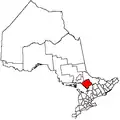 | |
|---|---|---|
| Townships | ||
| Villages | ||
| First Nations | ||
| Indian reserves | ||
| Local services boards | ||
| Unorganized areas | ||
| ||