New Haven and Northampton Canal
| New Haven and Northampton Canal | |
|---|---|
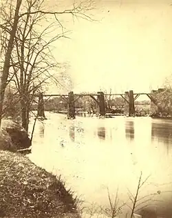
 Canal and railroad near Sleeping Giant in Hamden, Connecticut c. 1900 | |
Route of the New Haven and Northampton Canal with feeder canals | |
| Specifications | |
| Length | 86 miles (138 km) |
| Locks | 60[a] |
| History | |
| Principal engineer | Davis Hurd |
| Other engineer(s) | Henry Farnam |
| Construction began | 1825 |
| Date completed | 1835 |
| Date closed | 1847 |
Farmington Canal-New Haven and Northampton Canal | |
| Location | New Haven, Connecticut to Northampton, Massachusetts |
| Coordinates | 42°00′35″N 72°46′04″W / 42.0098°N 72.7679°W (MA border) 41°19′N 72°55′W / 41.31°N 72.91°W (New Haven outlet) |
| Area | 247.6 acres (100.2 ha) |
| NRHP reference No. | 85002664 |
| Added to NRHP | September 12, 1985 |
The New Haven and Northampton Canal was a major private canal built in the early 19th century to provide water transportation from New Haven into the interior of Connecticut and Massachusetts, ending in the Connecticut River at Northampton. Its Connecticut segment was known as the Farmington Canal and the Massachusetts segment the Hampshire and Hampden Canal.
Built after the Erie Canal, the New Haven and Northampton Canal was a major civil engineering project and at 86 miles (138 km) New England's longest canal. The route improved access to freight for manufacturers and communities in the region. However, as a private venture the canal was a financial failure and only operated along its full extent from 1835 to 1847. With the advent of rail transport, the canal company and right-of-way was quickly converted to a railroad, which was in more recent years converted to a rail trail. Few of the canal's original structures remain but short sections of canal bed and towpath survive as well as several locks.
History
Background
During the early 19th century, the Connecticut River was the most efficient and commercially significant route into the interior of New England. Towns and cities along the river, such as Hartford, Connecticut, benefited from their position and access to water transport. However, Hartford's co-capital at the time, New Haven, relied on difficult overland access to the interior, and a canal had been considered since at least the 1780s.[1] By the time the Erie Canal had begun operations canal enthusiasm was at its height. New Haven businessmen and town representatives met on January 29, 1822 in Farmington to hire the Erie's chief engineer, Benjamin Wright, to survey a route for a canal.[2]
Wright hired Eli Whitney Blake to conduct a preliminary survey, and wrote a positive report: "The terrain is favorably formed for a great work of this kind and a canal may be formed for considerable less expense per mile, than the cost of canals now in the making in the state of New York."[2] That same year, the Connecticut legislature granted a charter to the Farmington Canal Company, and on February 4, 1823, Massachusetts granted its corresponding charter to the Hampshire & Hampden Canal Company. After this second charter was granted, work began.[3]
A vastly more ambitious plan would have extended the canal north through the Connecticut River valley to Barnet, Vermont, crossing the Canadian border at Lake Memphremagog and the St. Francis River, before ending at the major shipping route of the St. Lawrence River.[4] In Connecticut, two side canals were also envisioned; one running from Farmington west through Unionville to New Hartford, the other linking to the Erie Canal via the Hudson River or the proposed (but never built) Boston and Albany Canal.[5]
Construction
Ground-breaking ceremonies took place on July 4, 1825 at the Massachusetts–Connecticut border. However, when Connecticut Governor Oliver Wolcott Jr. employed the ceremonial shovel, it broke.[6] Built before the advent of steam shovels, the canal was graded and dug out with manual labor and the assistance of ox-drawn ploughs and draft horses. The canal prism, or cross-section, was 20 feet (6.1 m) wide at the bottom, 6 feet (1.8 m) deep, and 44 feet (13 m) wide at the top. At a normal operating water level of 4 feet (1.2 m) the canal was 36 feet (11 m) wide. A 10 feet (3.0 m) wide towpath ran along one side.[7]
When completed, the canal was 86 miles (138 km) long, of which 56 miles (90 km) were in Connecticut and 30 miles (48 km) in Massachusetts. There were 28 locks constructed in the Connecticut canal, between New Haven and Granby. A guard lock near the state border partitioned the two sections, where the canal entered the Congamond Lakes in Southwick. Boats traversed open sections of Congamond with the help of a floating towpath. A further 32 locks were constructed in Massachusetts between Southwick and Northampton.[1]
Initially planned as a western branch, a feeder canal was built off a dam on the Farmington River near Unionville. Other feeders were constructed from the Westfield River, Little River, and Salmon Brook. The Westfield River feeder was particularly extensive at over 6 miles (9.7 km) and needed to be fully rebuilt in 1837.[8] Canal operation required vast amounts of water, and a significant amount would filter into the ground, through breeches, or otherwise be wasted.
Farmington Aqueduct

The canal makers reached a problem at the "great level", the stretch of land between locks in Southington and Granby, which was the longest distance of the canal at the same water level. Once the Farmington River was reached, the canal was about 50 feet (15 m) above river level, and the canal and river could not merge, so an aqueduct was built. The aqueduct spanned 280 feet (85 m) with 6 arches, spaced 40 feet (12 m) apart.[7]
The pillars that remained after the canal closed were noted as a state landmark through the 1950s, but the 1955 floods damaged the pillars beyond repair, and they were removed in 1956–58. The aqueduct's remnants are now preserved as part of the Farmington Land Trust.[9]
Whiting's Basin
Whiting's Basin, or Bristol Basin, was located in Plainville, between Whiting Street and West Main Street. Edna Whiting built a general store, and had doors leading directly to the canal for drop offs. Whiting's general store sold a variety of jelly, spices, grains, etc. Other notable items that passed through and were dropped off at Bristol Basin were the original Eli Terry clock weights, for the pillar and scroll clock.[10]
Financial problems
Significantly over-budget and plagued with constant maintenance issues, the canal was not a financial success. Only one year after the completion of the full length of the canal to Northampton, the original stock was a total loss estimated at over $1 million.[11] The "New Haven and Northampton Company" was formed in 1836 to take on the debt of the previous company and invest capital. While generating substantial revenue from tolls, outlays from maintenance and reconstruction efforts continued throughout. Canal banks were most often breached by freshets, and even on occasion by vandalism from disgruntled local land owners. The canal was inoperative in the winter and could also be shut down for extended periods during drought.[7]
The canal's later years saw advancements such as the linking of the Western Railroad in Westfield, Massachusetts and its most profitable year in 1844. However, a succession of storms and droughts shut down the canal through most of 1843 and 1845.[12] Inventor Benjamin Dutton Beecher tested an early screw propeller steamboat on the canal, reaching as far as Hamden.[13]
Railroad and closure
With the development of steam power the canal faced increased competition from steamboats on the Connecticut River. Furthermore, new railroads were much cheaper to maintain and operated year-round. In 1839 the Hartford and New Haven Railroad first linked Hartford and New Haven. Joseph Earl Sheffield was involved in financing the canal company from 1840, becoming at one point its major shareholder. Having chartered the New York and New Haven Railroad in 1844, Sheffield suggested to the canal's chief engineer Henry Farnam that the railroad be built along the canal and the canal abandoned.[14]
In February 1846 the canal's owners decided to convert the project to rail, hiring Alexander Twining to survey a route. The New Haven and Northampton Railroad was built alongside the canal so as not the interfere with its operation, which remained open in 1846 and 1847. The railroad opened to Plainville in January 1848, at which time the canal was officially closed.[15] This railroad merged with the New York, New Haven and Hartford Railroad in 1887. Portions of the railway were in use up until the 1980s. A two-mile section from the Main/Whiting Street intersection in Plainville to Townline Road sees limited use.
Today
Farmington Canal Locks
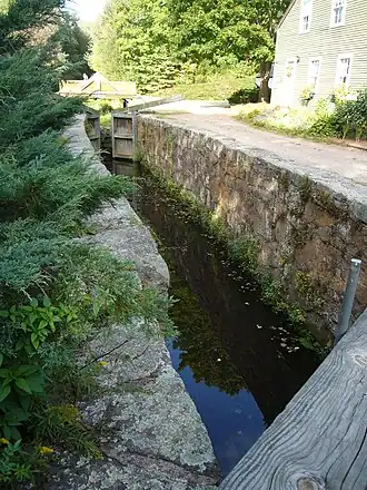
Locks 1-8 have been demolished. Lock 12 is restored and has movable lock gates to simulate function but does not actually function as a lock because there is not enough water flow to fill the lock, and the lock gates do not seal well enough to allow the lock to fill and raise the water level. The lock keeper's house at gate 12 has also been restored. Lock 13 is in the woods and overgrown. The lock keeper's house for lock 13 is no longer standing; the foundation and well remain behind the lock. Lock 14 is still recognizable; however, walls have collapsed, and the inside of lock 14 is dry. The lock keeper's house is still standing, and plans to convert it for municipal services building are planned.[16]
Rails-to-Trails
During the 1990s, the railroad right-of-way was converted to a rail trail for recreational use, currently known in Connecticut as the Farmington Canal Heritage Trail. A longer proposed trail, the New Haven and Northampton Canal Greenway extends the trail through Massachusetts, ending in Northampton and linking to the western terminus of the Mass Central Rail Trail.[17]
National Register of Historic Places
The entire length of the canal right of way in Connecticut (covering 25 segments and a total area of 247.6 acres) from Suffield to New Haven was listed on the National Register of Historic Places (NRHP) in 1985 under the name "Farmington Canal-New Haven and Northampton Canal". The 1984 NRHP nomination document provides a detailed history, and describes 45 separate bridges, aqueducts, weirs and other surviving features.[18]
The Farmington Canal Lock in Cheshire, Connecticut, and the Farmington Canal Lock No. 13 in Hamden, Connecticut were listed separately on the NRHP in 1973 and 1982, respectively. Those are locks 12 and 13 out of 28 original locks on the Farmington Canal.[18]
An initiative has been ongoing since at least 2020 to submit Massachusetts sections of the canal for inclusion in the NRHP.[19][20]
See also
- New Haven and Northampton Railroad
- New Haven and Northampton Canal Greenway
- Farmington Canal State Park Trail
- Lockville Historic District, which has a canal prism and lock remnant
Notes
References
Citations
- ^ a b c Walter 2006.
- ^ a b Harte 1933, p. 24.
- ^ Camposeo 1977, p. 39.
- ^ Camposeo 1977, p. 42.
- ^ Camposeo 1977, p. 46.
- ^ Harte 1933, p. 29.
- ^ a b c Walter 2016.
- ^ Camposeo 1977, p. 48.
- ^ "Canal Aqueduct". Farmington Land Trust. Retrieved October 27, 2023.
- ^ Beals, Carleton (1954). Our Yankee Heritage. pp. 107–109.
- ^ Harte 1933, p. 22.
- ^ Camposeo 1977, p. 49.
- ^ "Benjamin Dutton Beecher had a Penchant for Invention". Connecticut History. May 22, 2022. Retrieved August 17, 2025.
- ^ Farnum 1889, p. 23.
- ^ Camposeo 1977, p. 51.
- ^ personal encounters with the canal locks, and paper work printed at each station among the canal locks
- ^ "History". Farmington Canal Heritage Trail & Farmington River Trail. Archived from the original on October 15, 2021. Retrieved October 15, 2021.
- ^ a b Raber and Clouette 1984.
- ^ "Hampshire and Hampden Canal Documentation Project". Pioneer Valley Planning Commission.
- ^ Nason and Waski 2022.
Sources
- Camposeo, James M. (1977). "The history of the canal system between New Haven and Northampton (1822–1847)" (PDF). Historical Journal of Western Massachusetts.
- Farnum, H. W. (1889). Henry Farnam (PDF). Tuttle, Morehouse & Taylor.
- Harte, Charles Rufus (1938). Connecticut's Canals. OCLC 14768451.
- Harte, Charles Rufus (1933). Some engineering features of the old Northampton Canal (PDF). Connecticut Society of Civil Engineers.
- Raber, Michael S.; Clouette, Bruce (1985). National Register of Historic Places Inventory-Nomination: Farmington Canal (New Haven and Northampton Canal) / Farmington Canal (Report). National Park Service.
- Walter, Carl E. (2016). Farmington Canal Maps (Map).
- Walter, Carl E. (2006). Map of the Hampshire & Hampden Canal (Map).
- Nason, Zachary; Waski, Nadia (December 2022). Archaeological Reconnaissance Survey for the Hampshire and Hampden Canal Documentation Project, Southwick, Westfield, Russell, Southampton, Easthampton, and Northampton, Massachusetts (PDF) (Report). SWCA Environmental Consultants.
External links
- Simsbury Free Library presents: Farmington Canal Talk
- The Ill-Fated Farmington Canal, Connecticut Explored
- New England’s Grand Ambition: The Farmington Canal, Connecticut History
- Map exhibiting the Farmington & Hampshire & Hampden canals together with the line of their proposed continuation through the Valley of the Connecticut River to Canada
| Topics | |
|---|---|
| Lists by state |
|
| Lists by insular areas | |
| Lists by associated state | |
| Other areas | |
| Lists of specific structure types | |
| Related | |