Finley, North Dakota
Finley, North Dakota | |
|---|---|
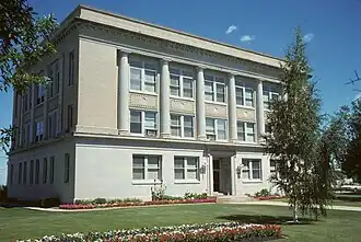 The Steele County Courthouse in Finley | |
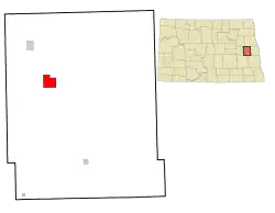 Location of Finley, North Dakota | |
| Coordinates: 47°30′45″N 97°50′14″W / 47.512515°N 97.837267°W | |
| Country | United States |
| State | North Dakota |
| County | Steele |
| Founded | 1897 |
| Area | |
• Total | 3.487 sq mi (9.030 km2) |
| • Land | 3.487 sq mi (9.030 km2) |
| • Water | 0.000 sq mi (0.000 km2) |
| Elevation | 1,457 ft (444 m) |
| Population | |
• Total | 401 |
• Estimate (2024)[4] | 391 |
| • Density | 115.00/sq mi (44.41/km2) |
| Time zone | UTC–6 (Central (CST)) |
| • Summer (DST) | UTC–5 (CDT) |
| ZIP Code | 58230 |
| Area code | 701 |
| FIPS code | 38-26420 |
| GNIS feature ID | 1036033[2] |
| Sales tax | 8.0%[5] |
| Website | finleynd.net |
Finley is a city in Steele County, North Dakota, United States. It is the county seat of Steele County.[6] The population was 401 at the 2020 census,[3] and was estimated to be 391 in 2024.[4] Finley was founded in 1897.
History
Finley was founded in 1897. In 1911, a train wreck in Finley caused by a broken rail killed six and injured 13.[7] In 1919, the county seat was transferred to Finley from Sherbrooke, North Dakota.[8]
Geography
According to the United States Census Bureau, the city has a total area of 3.47 square miles (8.99 km2), all land.[1]
Demographics
| Census | Pop. | Note | %± |
|---|---|---|---|
| 1910 | 516 | — | |
| 1920 | 599 | 16.1% | |
| 1930 | 587 | −2.0% | |
| 1940 | 677 | 15.3% | |
| 1950 | 671 | −0.9% | |
| 1960 | 808 | 20.4% | |
| 1970 | 809 | 0.1% | |
| 1980 | 718 | −11.2% | |
| 1990 | 543 | −24.4% | |
| 2000 | 515 | −5.2% | |
| 2010 | 445 | −13.6% | |
| 2020 | 401 | −9.9% | |
| 2024 (est.) | 391 | [4] | −2.5% |
| U.S. Decennial Census[9] 2020 Census[3] | |||
2020 census
As of the 2020 census, there were 401 people, 188 households, and 108 families residing in the city.[10]
2010 census
As of the 2010 census, there were 445 people in 206 households, including 125 families, in the city. The population density was 128.2 inhabitants per square mile (49.5/km2). There were 245 housing units at an average density of 70.6 per square mile (27.3/km2). The racial makup of the city was 95.7% White, 0.2% African American, 2.2% Native American, 0.7% from other races, and 1.1% from two or more races. Hispanic or Latino of any race were 0.7%.
There were 206 households 25.7% had children under the age of 18 living with them, 49.0% were married couples living together, 5.8% had a female householder with no husband present, 5.8% had a male householder with no wife present, and 39.3% were non-families. 32.5% of households were one person and 19.9% were one person aged 65 or older. The average household size was 2.16 and the average family size was 2.67.
The median age was 45.9 years. 21.1% of residents were under the age of 18; 5.6% were between the ages of 18 and 24; 22.2% were from 25 to 44; 27.1% were from 45 to 64; and 23.8% were 65 or older. The gender makeup of the city was 49.4% male and 50.6% female.
2000 census
As of the 2000 census, there were 515 people in 224 households, including 144 families, in the city. The population density was 147.4 inhabitants per square mile (56.9/km2). There were 256 housing units at an average density of 73.3 per square mile (28.3/km2). The racial makup of the city was 97.28% White, 1.75% Native American, 0.39% from other races, and 0.58% from two or more races. Hispanic or Latino of any race were 0.19% of the population.
Of the 224 households 28.1% had children under the age of 18 living with them, 54.9% were married couples living together, 8.0% had a female householder with no husband present, and 35.7% were non-families. 32.6% of households were one person and 18.3% were one person aged 65 or older. The average household size was 2.30 and the average family size was 2.95.
The age distribution was 26.0% under the age of 18, 6.4% from 18 to 24, 19.2% from 25 to 44, 23.9% from 45 to 64, and 24.5% 65 or older. The median age was 43 years. For every 100 females, there were 95.8 males. For every 100 females age 18 and over, there were 89.6 males.
The median household income was $32,917 and the median family income was $43,417. Males had a median income of $34,844 versus $17,500 for females. The per capita income for the city was $17,989. About 10.1% of families and 10.7% of the population were below the poverty line, including 18.4% of those under age 18 and 3.7% of those age 65 or over.
Notable people
- LaurieBeth Hager, member of the North Dakota House of Representatives
- Harvey B. Knudson (1903–1978), attorney and justice of the North Dakota Supreme Court
- Peter O. Sathre, attorney and 16th North Dakota Attorney General
References
- ^ a b "2024 U.S. Gazetteer Files". United States Census Bureau. Retrieved July 20, 2025.
- ^ a b U.S. Geological Survey Geographic Names Information System: Finley, North Dakota
- ^ a b c "Explore Census Data". United States Census Bureau. Retrieved November 3, 2023.
- ^ a b c "City and Town Population Totals: 2020-2024". United States Census Bureau. Retrieved July 20, 2025.
- ^ "Finley, North Dakota sales tax rate". Avalara. Retrieved July 20, 2025.
- ^ "Find a County". National Association of Counties. Retrieved July 20, 2025.
- ^ Jackson, William (2021). Dakota Mysteries & Oddities, 2022 Edition. Dickinson, ND: Valley Star Publishing. p. 41. ISBN 978-0-9677349-9-6.
- ^ Hellmann, Paul T. (May 13, 2013). Historical Gazetteer of the United States. Routledge. p. 836. ISBN 978-1135948597. Retrieved November 30, 2013.
- ^ "Decennial Census of Population and Housing". www.census.gov. United States Census Bureau. Retrieved June 4, 2015.
- ^ "US Census Bureau, Table P16: Household Type". United States Census Bureau. Retrieved July 20, 2025.
External links
- City of Finley – Official website
- Finley 75th, diamond jubilee, 1897-1972 : from sod to mod from the Digital Horizons website
Municipalities and communities of Steele County, North Dakota, United States | ||
|---|---|---|
| Cities |  | |
| Townships |
| |
| Unincorporated communities | ||