East Cape
East Cape | |
|---|---|
 East Cape on the right hand end of the Raukūmara Range | |
.svg.png) East Cape | |
| Coordinates: 37°41′21″S 178°32′54″E / 37.6892°S 178.5483°E | |
| Location | Gisborne District, New Zealand |
| Offshore water bodies | Pacific Ocean |
East Cape is the easternmost point of the main islands of New Zealand. It is at the northern end of the Gisborne District of the North Island.[1] East Cape was originally named "Cape East" by British explorer James Cook during his 1769–1779 voyage. It is one of four New Zealand cardinal capes he named, along with North Cape, West Cape and South Cape.[2]
The name "East Cape" is also used for the part of the Gisborne District north of the Poverty Bay area, but more often as a metonym for the whole Gisborne District.[3]
Maritime New Zealand operates the East Cape Lighthouse, located at the cape's easternmost point.[4] The small Whangaokeno / East Island, also known as Motu o Kaiawa, is directly offshore.[5][6] The NZ Transport Agency upgraded the Horoera Bridge in 2017,[7] giving campervans and other heavy vehicles full access to the lighthouse.[8] It replaced a temporary Bailey bridge installed in 2015.[9]
-
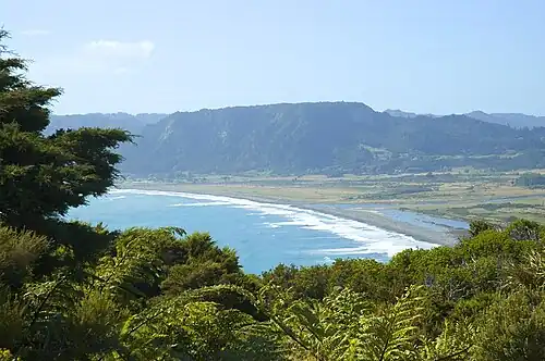 Te Araroa and ranges towards East Cape
 -
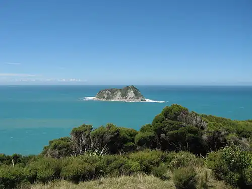 Looking from East Cape towards Whangaokeno / East Island
Demographics
East Cape statistical area, which includes Wharekahika / Hicks Bay, Te Araroa and Tikitiki, covers 991.22 km2 (382.71 sq mi)[10] and had an estimated population of 1,560 as of June 2024,[11] with a population density of 1.6 people per km2.
| Year | Pop. | ±% p.a. |
|---|---|---|
| 2006 | 1,563 | — |
| 2013 | 1,419 | −1.37% |
| 2018 | 1,389 | −0.43% |
| 2023 | 1,509 | +1.67% |
| Source: [12][13] | ||
East Cape had a population of 1,509 in the 2023 New Zealand census, an increase of 120 people (8.6%) since the 2018 census, and an increase of 90 people (6.3%) since the 2013 census. There were 765 males, 741 females, and 3 people of other genders in 492 dwellings.[14] 1.6% of people identified as LGBTIQ+. The median age was 36.9 years (compared with 38.1 years nationally). There were 384 people (25.4%) aged under 15 years, 258 (17.1%) aged 15 to 29, 624 (41.4%) aged 30 to 64, and 240 (15.9%) aged 65 or older.[12]
People could identify as more than one ethnicity. The results were 23.3% European (Pākehā); 91.7% Māori; 2.4% Pasifika; 1.0% Asian; 0.2% Middle Eastern, Latin American and African New Zealanders (MELAA); and 0.4% other, which includes people giving their ethnicity as "New Zealander". English was spoken by 95.0%, Māori by 42.1%, and other languages by 1.4%. No language could be spoken by 2.2% (e.g. too young to talk). New Zealand Sign Language was known by 0.6%. The percentage of people born overseas was 3.0, compared with 28.8% nationally.[12]
Religious affiliations were 33.8% Christian, 4.0% Māori religious beliefs, 0.2% Buddhist, 0.4% New Age, and 0.6% other religions. People who answered that they had no religion were 54.1%, and 7.8% of people did not answer the census question.[12]
Of those at least 15 years old, 120 (10.7%) people had a bachelor's or higher degree, 606 (53.9%) had a post-high school certificate or diploma, and 393 (34.9%) people exclusively held high school qualifications. The median income was $26,700, compared with $41,500 nationally. 33 people (2.9%) earned over $100,000 compared to 12.1% nationally. The employment status of those at least 15 was 378 (33.6%) full-time, 138 (12.3%) part-time, and 75 (6.7%) unemployed.[12]
References
- ^ Hariss, Gavin. "East Cape, Gisborne". topomap.co.nz. NZ Topo Map.
- ^ "Chart of New Zealand – J Cook 1769–70". 1770.
- ^ Soutar, Monty (1 March 2015). "East Coast region – Overview". Te Ara – the Encyclopedia of New Zealand. Ministry for Culture and Heritage. Retrieved 28 August 2023.
- ^ East Cape Lighthouse Archived 14 May 2010 at the Wayback Machine, Maritime New Zealand. Retrieved 1 December 2009.
- ^ Also known as Motu o Kaiawa, see Kate MacIntyre, Te Whanau a Apanui and the East Coast Inquiry District Archived 23 April 2019 at the Wayback Machine, Waitangi Tribunal Scoping Report, Wai 900 #A9, p. 37.
- ^ East Island / Whangaokeno, Rodent Invasion Project, Department of Statistics, University of Auckland. Retrieved 1 December 2009.
- ^ "Dropout delays bridge rebuild". Gisborne Herald. 24 July 2017. Archived from the original on 18 May 2019. Retrieved 18 May 2019.
- ^ "Bridging the gap to East Cape Lighthouse". Gisborne Herald. 17 August 2017. Archived from the original on 18 May 2019. Retrieved 18 May 2019.
- ^ Ashton, Andrew (3 December 2015). "East Coast Lighthouse opens up for freedom campers". Gisborne Herald. Archived from the original on 1 February 2016. Retrieved 18 May 2019.
- ^ "Stats NZ Geographic Data Service". Statistical Area 2 2023 (generalised). Retrieved 28 July 2025.
- ^ "Aotearoa Data Explorer". Statistics New Zealand. Retrieved 26 October 2024.
- ^ a b c d e "Totals by topic for individuals, (RC, TALB, UR, SA3, SA2, Ward, Health), 2013, 2018, and 2023 Censuses". Stats NZ – Tatauranga Aotearoa – Aotearoa Data Explorer. East Cape (204700). Retrieved 3 October 2024.
- ^ "Statistical area 1 dataset for 2018 Census". Statistics New Zealand. March 2020. East Cape (204700). 2018 Census place summary: East Cape
- ^ "Totals by topic for dwellings, (RC, TALB, UR, SA3, SA2, Ward, Health), 2013, 2018, and 2023 Censuses". Stats NZ – Tatauranga Aotearoa – Aotearoa Data Explorer. Retrieved 3 October 2024.