Armour, Ontario
Armour | |
|---|---|
| Township of Armour | |
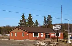 Municipal office, 2011 | |
| Etymology: John Douglas Armour.[1] | |
 Armour Location in Southern Ontario | |
| Coordinates: 45°37′44″N 79°20′38″W / 45.62889°N 79.34389°W[2] | |
| Country | Canada |
| Province | Ontario |
| District | Parry Sound |
| Incorporated | 1881 |
| Government | |
| • Type | Township |
| • Mayor | Rod Ward |
| • MP | Scott Aitchison (CPC) |
| • MPP | Graydon Smith (OPC) |
| Area | |
| • Land | 163.52 km2 (63.14 sq mi) |
| Population (2021)[3] | |
• Total | 1,459 |
| • Density | 8.9/km2 (23/sq mi) |
| Time zone | UTC-5 (EST) |
| • Summer (DST) | UTC-4 (EDT) |
| Postal code span | P0A |
| Area codes | 705, 249 |
| Website | www |
Armour is a township in the Canadian province of Ontario.[2][4][5]
Located in the Almaguin Highlands region of Parry Sound District, the township surrounds but does not include the village of Burk's Falls. It was named in honour of Judge John Douglas Armour.[1]
Communities
The township includes the communities of Berriedale, Carss, Chetwynd, Katrine and Pickerel Lake.
Katrine overlooks Doe Lake, which is located on the west side of the village. Three Mile Lake and Deer Lake are located about 5 km east of the village. There is also a small public beach on Doe Lake, and a community centre located on Ontario Highway 11.[6]
History
Armour Township was established as part of The Free Grants and Homestead Act in 1868, which encouraged settlement of the area. In 1881, it was incorporated, with James Coleman as its first reeve.[7]
In 1885, the Grand Trunk Railway was built through Armour.[7]
In 1890, the Village of Burk's Falls split off from the township to form a separate village municipality.[7]
In 1916, Highway 11 was built through the township.[7]
Demographics
In the 2021 Census of Population conducted by Statistics Canada, Armour had a population of 1,459 living in 667 of its 1,087 total private dwellings, a change of 3.2% from its 2016 population of 1,414. With a land area of 163.52 km2 (63.14 sq mi), it had a population density of 8.9/km2 (23.1/sq mi) in 2021.[3]
|
|
| |||||||||||||||||||||||||||||||||||||||||||||||||||||||||||||||||||||||||||
| Population counts are not adjusted for boundary changes. Source: Statistics Canada[8][9][10][11][12] | |||||||||||||||||||||||||||||||||||||||||||||||||||||||||||||||||||||||||||||
Mother tongue (2021):[3]
- English as first language: 93.5%
- French as first language: 1.7%
- English and French as first languages: 0%
- Other as first language: 4.5%
See also
References
- ^ a b "The Honourable Mr. Justice John Douglas Armour". Township of Armour. Archived from the original on July 6, 2011. Retrieved August 17, 2010.
- ^ a b "Armour". Geographical Names Data Base. Natural Resources Canada. Retrieved January 9, 2021.
- ^ a b c d "Armour, Ontario (Code 3549019) Census Profile". 2021 census. Government of Canada - Statistics Canada. Retrieved July 21, 2025.
- ^ "Ontario Geonames GIS (on-line map and search)". Ontario Ministry of Natural Resources and Forestry. 2014. Retrieved January 9, 2021.
- ^ Restructured municipalities - Ontario map #4 (Map). Restructuring Maps of Ontario. Ontario Ministry of Municipal Affairs and Housing. 2006. Archived from the original on April 10, 2014. Retrieved January 9, 2021.
- ^ "Katrine Ontario". Almaguin Communities. Almaguin Highlands Ontario Inc. Retrieved January 7, 2009.
- ^ a b c d "History". www.armourtownship.ca. Township of Armour. Retrieved July 21, 2025.
- ^ 1996, 2001, 2006
- ^ Statistics Canada 2011 Census - Armour Census Profile
- ^ "Census Profile, 2016 Census: Armour, Township". Statistics Canada. Retrieved June 28, 2019.
- ^ Eighth Census of Canada 1941 - Volume II - Population by Local Subdivisions (Report). Dominion Bureau of Statistics. 1944. CS98-1941-2.
- ^ "1971 Census of Canada - Population Census Subdivisions (Historical)". Catalogue 92-702 Vol I, part 1 (Bulletin 1.1-2). Statistics Canada. July 1973.
External links
| Towns | 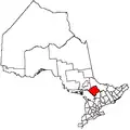 | |
|---|---|---|
| Townships | ||
| Villages | ||
| First Nations | ||
| Indian reserves | ||
| Local services boards | ||
| Unorganized areas | ||
| ||